
-
 1873 Hits
-
 74.92% Score
-
 5 Votes
|
|
Mountain/Rock |
|---|---|
|
|
47.34010°N / 11.53417°E |
|
|
Mountaineering, Scrambling |
|
|
Summer, Fall |
|
|
8432 ft / 2570 m |
|
|
Overview
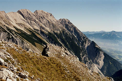
Hohe Fürleg is part of the Gleirsch - Halltal - subrange of Karwendel area. This long stretched subrange to the south of Karwendel hosts many wellknown and frequented Karwendel peaks. Hohe Fürleg and the neighbouring summits, Walderkampspitze and Tratenspitze, are, luckily enough, not among them. The full traverse of these three mountains still is a rather lonely and demanding outing, not far away from the crowded Inntal valley and the town of Innsbruck. It is in parts an easy rock climb and an airy walk on long ridges in a fantastic landscape. Thank God you still find those rather lonely peaks within the crowded Alps.
Standing high above Inntal valley to the south, Vomper Loch to the north, an impressive, lonely and wild Karwendel valley, in close vicinity to some of the most impressive peaks of Karwendel, Hohe Fürleg is a prime lookout and a long, demanding and great hike / climb. It stands in the immediate vicinity to Großer Bettelwurf, one of the highest Karwendel mountains.


Hohe Fürleg is the culmination point of the east - west - running ridge, coming up from Hundskopf, the easternmost and, despite of its denomination, an interesting peak. At Hohe Fürleg, the ridge bends to the north, thus surrounding Fallbachkar cirque, southwest of our summit, and then to the west again, going up to the slightly higher, ragged and difficult Fallbachkartürme and then to 200 m higher Großer Bettelwurf, looming above Hohe Fürleg.
Getting There
Trailheads for Hohe Fürleg are:
- Hinterhornalm at about 1550 m height above Gnadenwald / Inntal valley, accessible via a toll road
- Halltal parking area above the village of Absam
You reach the trailhead at Hinterhornalm
by car:
From Innsbruck, Salzburg or Munich use the highway A 12 (toll road) to the exit "Wattens". Follow the indications to Fritzens and to Gnadenwald. After Gnadenwald take the toll road to the right up to Hinterhornalm. Toll is payed at a machine, have enough coins with you!
by train:
The next railway station is "Fritzens / Wattens". There is, however, as far as I know no bus connection to Gnadenwald and to Hinterhornalm.


You reach the trailhead at Absam
by car:
From Innsbruck, Salzburg or Munich use the highway A 12 (toll road) to the exit "Hall in Tirol". Follow the indications to Absam. Above the village go straight on where the main road turns right in direction to Gnadenwald. The parking area (fee required) is about 500 m further up the road.
by train:
The next railway station is "Hall in Tirol". Busses or taxi bring you up to the trailhead.
Routes Overview
Routes Overview
Hinterhornalm route:
Take the trail from Hinterhornalm to the northeast (signs to "Hundskopf, Erich-Kuen-Klettersteig""). After reaching the main ridge turn left / west until you reach a trail junction. There are two alternatives to go on:
- Traverse Hundskopf summit, ascending via the secured normal route (via ferrata rated A / B) and descending the Erich Kuen Klettersteig (via ferrata rated B / C; short but nice) to the so called "Mandl-und-Weibele-Scharte (man and women col).
- Alternatively turn right at the trail junction and follow the traverse trail on the north side of Hundskopf until it reaches the Mandl-und-Weibele-Scharte.
- A more spectacular ascent to Mandl-und-Weibele-Scharte is a steep and unmarked rock chute, called Leckrinne, rated UIAA grade II+. It is a south side chute west of Hundskopf, it ends directly at Mandl-und-Weibele-Scharte.
From the col follow a narrow and marked trail, first on the south side of the ridge (some easy rock scramble) and then directly on the ridge, called "Die Traten", to the summit block of Tratenspitze. Ascend with some UIAA grade I moves and on steep rocks the summit block of Tratenspitze.


From Tratenspitze follow the rock ridge easily and short to the summit of Walderkampspitze.


From Walderkampspitze descend a short and steep rock step to a near level part of the ridge. Follow the ridge to the west and climb then in some steep and exposed ups and downs (bad rock in some parts!) on its south side to the broad summit of Hohe Fürleg (some UIAA grade I and II - moves required).
Absam route:
From the Halltal parking area follow the (actually still closed) Halltal road for about 1,2 km to the boulder and climbing area of Halltal. Take the trail up to "Alpensöhne Hütte" and to the summit of Hüttenkopf. Descend into Wechselscharte. Ascend on a sort of via ferrata the so called "Nagelwand" to the summit of Kleine Wechselspitze. Traverse into Fallbachkar, ascend steeply this cirque to the beginning of the marked rock part of the route to Hohe Fürleg. There is a series of chutes leading up to the north ridge of Hohe Fürleg. Follow the ridge shortly up to the summit.


Long and demanding ascent!
Traverse route:
Best done from Hinterhornalm. You traverse Hundskopf, Tratenspitze, Walderkampspitze, Hohe Fürleg and Kleiner Wechselkopf.
If you can park two cars at Hinterhornalm and at Halltal parking area, descend from Kleine Wechselspitze to Wechselscharte and boot-ski down the scree chute from Wechselscharte into Halltal.
If you have to return to Hinterhornalm, ascend Hüttenkopf from Wechselscharte and descend to Alpensöhne Hütte. Starting at Alpensöhne Hütte there is a traverse trail which ends at the last switchback of the road to Hinterhornalm. A very long day!
Red Tape & Accomodation
Red Tape:
Hohe Fürleg and the ascent routes are part of Alpenpark Karwendel, an important and strictly protected national park.
There is no entrance fee for the park but many regulations to follow.
Please respect the following National Park Rules:

Accommodation:

Mountain Huts:
Alpensöhne Hütte (no overnight stay)
Hinterhornalm (no overnight stay)
Gear & Mountain Condition
Hohe Fürleg is a summer and autumn mountain, best accessible when there is no or little snow.
You need climbing abilities up to short parts of UIAA grade II in sometimes frail and bad rock and a good stamina, if you do the traverse route. Helmet is recommended. Bring your via ferrata gear when traversing Hundskopf.


Weather:
Maps
Best map is:
Alpenvereinskarte, scale 1 : 25000,
- number 5/2, Karwendelgebirge, Mittleres Blatt, edition 2015 and
- number 5/3, Karwendelgebirge, Östliches Blatt, edition 2015
both with trails and UTM grid