
-
 1335 Hits
-
 75.81% Score
-
 6 Votes
|
|
Mountain/Rock |
|---|---|
|
|
47.34042°N / 11.54142°E |
|
|
Summer, Fall |
|
|
8235 ft / 2510 m |
|
|
Overview

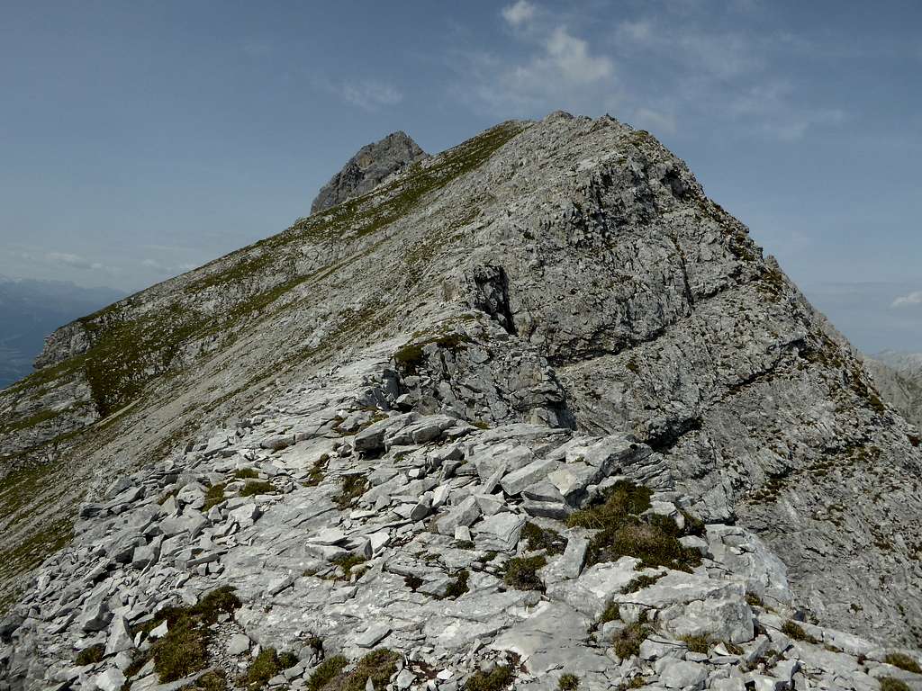
The long and impressive Gleirsch - Halltal - Range of Karwendel mountains has at its eastern end three nearly equally high peaks, wich offer a good traverse option. Tratenspitze is the eastern peak of a triumvirat, Walderkampspitze and Hohe Fürleg are the other two peaks, which can be easily combined together. In some guide books Tratenspitze is called east summit of Walderkampspitze, the latter not being far awy.
A sparsely marked route, mainly running on top of the ridges, connect Tratenspitze to Walderkampspitze and further on to Hohe Fürleg to the west and Manndl und Weibele col, a broad and impressive col between Inntal valley and Vomper Loch to the east. The next summit, positioned to the east of this col is Hundskopf, often inculded in a full traverse of that eastern part of the Gleirsch - Halltal range and hosting a short but nevertheless nice via ferrata (Erich Kuen Klettersteig).


Tratenspitze is not a very frequented summit. People who summit Tratenspitze do the full traverse or go to and fro Hohe Fürleg. The landscape, however, is fantastic with bizarre rock features, marvellous views down Inntal valley and impressive sights of the adjacent Karwendel mountains.
Getting There
Trailheads for Tratenspitze are:
- Hinterhornalm at about 1550 m height above Gnadenwald / Inntal valley, accessible via a toll road
- Halltal parking area above the village of Absam
You reach the trailhead at Hinterhornalm
by car:
From Innsbruck, Salzburg or Munich use the highway A 12 (toll road) to the exit "Wattens". Follow the indications to Fritzens and to Gnadenwald. After Gnadenwald take the toll road to the right up to Hinterhornalm. Toll is payed at a machine, have enough coins with you!
by train:
The next railway station is "Fritzens / Wattens". There is, however, as far as I know no bus connection to Gnadenwald and to Hinterhornalm.


You reach the trailhead at Absam
by car:
From Innsbruck, Salzburg or Munich use the highway A 12 (toll road) to the exit "Hall in Tirol". Follow the indications to Absam. Above the village go straight on where the main road turns right in direction to Gnadenwald. The parking area (fee required) is about 500 m further up the road.
by train:
The next railway station is "Hall in Tirol". Busses or taxi bring you up to the trailhead.
Routes Overview
Routes Overview
Hinterhornalm Trailhead:
Take the trail from Hinterhornalm to the northeast (signposts to Hundskopf) and ascend to the main ridge. Turn left there and continue on that trail until you reach a trail junction:
- Go right on a trail which traverses Hundskopf on its north side to Manndl und Weibele col, west of Hundskopf
- alternatively climb Hundskopf on its normal route (east ridge, via ferrata, graded A/B, easy) and descend Hundskopf using the Erich Kuen Klettersteig (via ferrata, west face of Hundskopf, rated B/C) to Manndl und Weibele col
- There is an alternative route to Manndl und Weibele col, using a rock chute (grade II in parts), the so called Leckrinne. For this go left on a trail starting shortly above Hinterhornalm trailhead until you reach a scree field below the chute. Ascend the scree and then climb up the chute which ends at Manndl und Weibele col.
From Manndl und Weibele col follow the narrow and scarcely marked trail to the west, first on the south side of the ridge, passing through a shallow rock chute and reaching the ridge in some zigzags after. Follow the ridge, which is called Die Traten up to the summit rocks. Tratenspitze is climbed on its right side over some steep rocks (grade I moves).


Absam route:
From the Halltal parking area follow the (actually still closed) Halltal road for about 1,2 km to the boulder and climbing area of Halltal. Take the trail up to "Alpensöhne Hütte" and to the summit of Hüttenkopf. Descend into Wechselscharte. Ascend on a sort of via ferrata the so called "Nagelwand" to the summit of Kleine Wechselspitze. Traverse into Fallbachkar, ascend steeply this cirque to the beginning of the marked rock part of the route to Hohe Fürleg. There is a series of chutes leading up to the north ridge of Hohe Fürleg. Follow the ridge shortly up to the summit. From Hohe Fürleg descend on the south side of the ridge, follow the route in frail rocks in some ups and downs (short parts being grade II) back to the ridge and follow it to Walderkampspitze. Descend the summit block, pass some airy parts of the ridge (grade I) and arrive at Tratenspitze.
Traverse route:
The traverse route is described on the Hohe Fürleg page.
Red Tape & Accommodation
Red Tape:
Tratenspitze and the ascent routes are part of Alpenpark Karwendel, an important and strictly protected National Park.
There is no entrance fee for the park but many regulations to follow.
Please respect the following National Park Rules:


Accommodation:
Mountain Huts:
Alpensöhne Hütte (no overnight stay)
Hinterhornalm (no overnight stay)
Gear & Mountain Condition
Tratenspitze is a summer and autumn mountain, best accessible when there is no or little snow.
Tratenspitze is easily accessible from Hinterhornalm, the only difficult part being the summit rocks which require some short grade I moves. If you do the traverse from or to Hohe Fürleg, you need climbing abilities up to short parts of UIAA grade II in sometimes frail and bad rock and a good stamina.
Helmet is recommended.
Bring your via ferrata gear when traversing Hundskopf.
Weather:
Maps
Best map is:
Alpenvereinskarte, scale 1 : 25000,
- number 5/2, Karwendelgebirge, Mittleres Blatt, edition 2015 and
- number 5/3, Karwendelgebirge, Östliches Blatt, edition 2015
both with trails and UTM grid