
-
 7077 Hits
-
 83.69% Score
-
 17 Votes
|
|
Mountain/Rock |
|---|---|
|
|
47.34682°N / 11.45750°E |
|
|
Spring, Summer, Fall, Winter |
|
|
8645 ft / 2635 m |
|
|
Overview
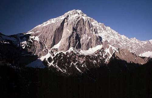 Dominating Kleiner Lafatscher above Halleranger (image of user luidger)
Life often tells us that it is better to deal with the big brother than with the little brother. But sometimes life is wrong as it is the case with the two brothers Großer and Kleiner Lafatscher. Having climbed both of them my favorite is the little brother.
The two Lafatscher brothers are part of the Gleiersch - Halltal range of Karwendel mountains and, as they both exceed 2.600 m, belong to the high Karwendel summits.
The Gleiersch - Halltal range is a dominating ridge with a nearly perpendicular drop of about 1000 m of altitude difference and more on its northern side. The south sides are built of steep slabs, meadows and rock faces, dominating Halltal valley to the east and Gleiersch valley to the west.
Kleiner Lafatscher stands above Lafatscher Joch, the most important col to traverse from the south side to the north side of the range. It is a rather prominent mountain when viewed from the east and from the north. The northern rockface above Halleranger (Anger = meadow) bears some of the finest and most wellknown climber routes of Karwendel.
As the notch between Kleiner and Großer Lafatscher, a huge summit block west of the summit of Kleiner Lafatscher, is not very deeply cut in, our summit does not look very prominent when viewed from its higher brother.
In former times the normal route to the top was a marked and maintained one. Nowadays with the many more or less experienced people hiking from one alpine club hut to the other the route is no longer maintained and signposted. Marks did fade away and the cairns of the lower part of the route are regularly destroyed so to prevent the less experienced from summiting.
Thus Kleiner Lafatscher is leading a calm life now. The summit register has only 10 pages of entries a year and if you are unlucky you will meet two, three or four people at the summit. The whole day.
Kleiner Lafatscher was first summited may, 26th 1881 by A. Zott, H. Zametzer, F. Kilger, H. Schwaiger. The famous northeast dihedral of the huge northern rockface (UIAA grade IV+ to VI-) was first climbed in 1932 by Matthias Auckenthaler.
Getting There
 Kleiner Lafatscher as seen from Thaurer Zunterkopf
There are several trailheads for Kleiner Lafatscher, depending on wether you choose to do a one day hike or summit this peak during a longer Karwendel traverse:
You reach Halltal
Current regulations for Halltal (08 / 2014):
Halltal is closed to public traffic and will be so in the future. This is due to security regulations (landslide areas along the road).
Actually there is a shuttle bus service on weekends with good weather during the summer months (see schedule and prices here ).
This bus starts at Absam / Halltal parking area and ends at the Sankt Magdalena mountain inn. With this bus it is possible to reach all the Halltal trailheads without walking or at least with only a short additional walk.
During the week and in autumn a taxi service is available to the trailheads; prices actually (2014) range from 18 € to 23 € up to 5 persons and 25 € to 30 € up to 8 persons.
Pfeißhütte can be reached from Scharnitz (best by MTB, otherwise a very long hike), from the mountain station of Hafelekar cable car, starting at Innsbruck or from the villages of Rum or Thaur between Innsbruck and Hall.
Halleranger Haus or Halleranger Alm can be reached from Scharnitz (again best by MTB, otherwise a very long hike) or from the villages of Schwanz / Vomp or Terfens, east of Hall.
Route Overview
The normal route to Kleiner Lafatscher starts at Lafatscher Joch (col) and uses the southeast ridge of the mountain.You reach Lafatscher Joch:
 Kleiner Lafatscher as seen from Issanger Kleiner Lafatscher as seen from Issanger |  Issanger and Rosskopf Issanger and Rosskopf |  Lafatscher Joch with normal route Lafatscher Joch with normal route |
Starting some 50 meters below the col on the south side you see a narrow footpath which zigzags up the steep scree and meadow slope of the lower southwest ridge up to a first peak in the ridge (easy rock scramble in the upper parts). There are some cairns and several foottrails guiding you up. At the first peak the ridge gets rocks and more exposed. Best is to follow the ridge crest (UIAA grade I / I+) up to the summit arete which you reach at its southernmost edge. Follow the easy summit ridge to the summit cross.
 Middle part of Lafatscher normal route Middle part of Lafatscher normal route |  Great views from normal route Great views from normal route |  The more difficult part of the normal route The more difficult part of the normal route |
Other more easier routes are:
Kleiner Lafatscher is a classic climbing mountain. There are several famous climbing routes on the north and northeast side of that mountain.
 Easy rock climb on normal route Easy rock climb on normal route |  Summit view to Bettelwurf Summit view to Bettelwurf |  Summit view to Grubenkarspitze, Eiskarlspitze, Hochnisslspitze Summit view to Grubenkarspitze, Eiskarlspitze, Hochnisslspitze |
Red Tape & Accommodation
 A view from Kleiner to Großer Lafatscher
Red Tape
Kleiner Lafatscher is part of the “Alpenpark Karwendel”, an important and strictly protected national park.
There is no entrance fee for the park but many regulations to follow.
There is a National Park Information Center at Hinterriß.
The road to Halltal is a toll road with restricted parking areas which should be respected.
Accommodation
Camping is not allowed within Alpenpark Karwendel.
Food and lodging can be found in
Mountain huts
 180 degree summit panorama
Gear & Mountain Condition
Kleiner Lafatscher is mainly a summer and autumn mountain. However, the south ascents to Lafatscher Joch tend to be free of snow earlier than other Karwendel regions. So you find some ascent entries in the summit register even in december, january, february and in early spring. The southeast ridge / normal route from Lafatscher Joch should be fun with some snow on it. Wildflowers of Kleiner Lafatscher: Gentiana punctata Wildflowers of Kleiner Lafatscher: Gentiana punctata |  Wildflowers of Kleiner Lafatscher: Aconitum napellus Wildflowers of Kleiner Lafatscher: Aconitum napellus |  Wildflowers of Kleiner Lafatscher: Hieracium piosella Wildflowers of Kleiner Lafatscher: Hieracium piosella |
The normal route to Kleiner Lafatscher needs climbing skills up to UIAA grade I+. Unexperienced may be secured with a rope.
Normal hiking gear and good shoes are sufficient. With snow everything is more difficult and complicated. So an ice axe and crampons can serve well during a snow ascent.
Current Weather:
Maps & Guide Book
 Wildflowers of Kleiner Lafatscher: Gentiana asclepiadea
Maps
Alpenvereinskarte, 1 : 25.000, Karwendelgebirge, Mittleres Blatt, number 5/2, 2008
Alpenvereinskarte, 1 : 50.000, Innsbruck und Umgebung
Guide Book
Walter Klier: Karwendel alpin, Alpenvereinsführer, Bergverlag Rother, München, 16th edition, 2011