
-
 6760 Hits
-
 77.48% Score
-
 8 Votes
|
|
Mountain/Rock |
|---|---|
|
|
47.34667°N / 11.42724°E |
|
|
Hiking |
|
|
Summer, Fall |
|
|
8448 ft / 2575 m |
|
|
Overview
Sonntagkarspitze is part of the Karwendel. It belongs to the east - west running Gleiersch-Halltal Chain and stands out above Sämertal and Isstal to the south and Hinterautal to the north. The summit is located about 8 km north of the town of Innsbruck. The neighbouring summits are Kaskarspitze in the west and Hintere Bachofenspitze to the east.A subridge diverges from the summit to the south, separating Kaskar in the west from Sonntagskar. This southridge is the normal ascent route to the summit.
While showing steep rockfaces to the north (see Karwendel panorama on the Karwendel main page) the south face of the mountain is more accessible through valleys, cirques and on different ridges. The connecting ridges between the summits can be climbed too, it is mainly UIAA grade I and easier with some parts of it are UIAA grade II. Those ridges are very exposed and do not have very good rock quality so you have to deal with lots of scree and loose rock.
Getting There
 Overview
There are several trailheads for choice.
From all trailheads you have to reach Pfeishütte, south of Sonntagkarspitze.
Pfeishütte is a very nice and recommendable mountain hut, erected at the very upper end of Sämertal on a meadow, called “In der Pfeis”. You normally will stay one night in Pfeishütte because of the long and / or exhausting trails leading to this remote mountain hut.
Pfeishütte can also be used as a “base camp” for some peak bagging: Praxmarerkarspitze, Kaskarspitze, Sonntagkarspitze, Hintere Bachofenspitze, Roßkopf, Stempeljochspitze, Pfeiser - / Latten - / Wildangerspitze, Rumerspitze with Goetheweg, Gleierschtaler Brandjoch, all those peaks and summits are more or less easily accessible from Pfeishütte or can be linked together to an interesting traverse over the connecting ridges.
Thaur or Rum near Innsbruck
Use the A 12, Inntal valley highway from Salzburg / Munich / Rosenheim / Kufstein or from Bregenz / Arlberg until exit Hall / Tirol. Follow road number 171 until Thaur or Rum is signposted. Look for parking possibilities in the upper parts of the villages near the beginning of the woods on the south slope of Karwendel.
Halltal
A beautiful and impressing valley !
Exit the Inntal valley highway likewise at Hall / Tirol. At Hall, follow Salzbergstraße to Absams and go on to Halltal. Halltal road is a toll road, pay your fee at an automat at the beginning of the road. Follow the road up into the steep Halltal until you reach the very last parking possibility.
Current regulations for Halltal (08 / 2014):
Halltal is closed to public traffic and will be so in the future. This is due to security regulations (landslide areas along the road).
Actually there is a shuttle bus service on weekends with good weather during the summer months (see schedule and prices here ).
This bus starts at Absam / Halltal parking area and ends at the Sankt Magdalena mountain inn. With this bus it is possible to reach all the Halltal trailheads without walking or at least with only a short additional walk.
During the week and in autumn a taxi service is available to the trailheads; prices actually (2014) range from 18 € to 23 € up to 5 persons and 25 € to 30 € up to 8 persons.
Innsbruck / Hafelekar cableway
Exit the Inntal valley highway likewise at Hall / Tirol to avoid the traffic in Innsbruck center. At Hall, follow road number 171 in the direction of Innsbruck. At Innsbruck don´t cross the river Inn, keep going on the north side of the river (Hallstraße) until “Hungerburg” is signposted. Hungerburg is the valley station of the Hafelekar cableway.
Scharnitz
Use the highway A 95 from Munich to Garmisch-Partenkirchen. Proceed on B 2 to Mittenwald and pass the frontier Germany / Austria at Scharnitz. At Scharnitz church use the road to the beginning of the “Karwendeltäler” (signposted). There are parking areas with fees. Use, if possible, the last one.
Scharnitz and Innsbruck can be reached by railroad, too. From Innsbruck there are bus connections to Rum, Thaur and Absams. As far as I know there are no busses going into Halltal.
Routes Overview to Pfeishütte
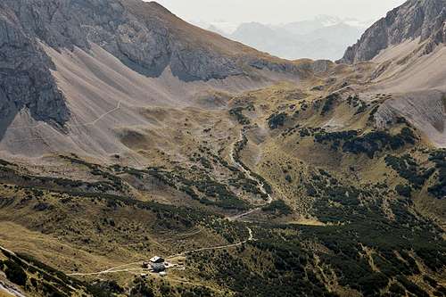 Pfeishütte (10-09-2006)
First of all you have to reach Pfeishütte:
Thaur or Rum
This is a strenuous hike because you use the south slopes of Karwendel and you have to overcome about 1500 meters of altitude difference to reach Pfeishütte.
From both villages follow the signposted and marked trails up to
Thaurer Alm
, a private mountain hut with overnight service. At Thaurer Alm follow trail number 218 to the west; after some 15 minutes there is a trail junction. Leave number 218 and follow the steep trail moving up the south slopes. It climbes up the south slopes of Pfeiser Spitze and reaches Thaurer Joch (2099 m). From Thaurer Joch descend to Pfeishütte.If you stay at Pfeishütte for the night you might summit Rumerspitze or Pfeiser Spitze from Thaurer Joch.
Halltal
Halltal is the nearest trailhead to Pfeishütte. You might do some of the Pfeiser summits from Halltal in one day without staying overnight.
From the last parking area follow Halltal up to Herrenhäuser, the old saltmine. Continue on trail number 221 up to Issjöchl and the north slopes of Lattenspitze / Wildangerspitze. The trail crosses the large scree fields of the upper Halltal and zigzags steeply up to Stempeljoch. From Stempeljoch it´s an easy walk down to Pfeishütte.
Alternatively you can follow the trail in the direction of Lafatscher Joch, beginning at the last Halltal parking area (signposts). You enter the beautiful meadwos of Issanger and proceed trail number 223 up to a trail junction with trail number 222. Follow this one to the west, it is a panoramic trail which traverses the south slopes of Lafatscher and Bachofenspitze and ends at Stempeljoch.
Innsbruck
From Innsbruck use the cableway up to Hafelekarspitze. Take the trail number 219 to the east. It is called “Goetheweg” and it is a beautiful panoramic trail mostly at the ridge crest between Hafelekarspitze and Gleierschtaler Brandjoch. You can summit Hafelekarspitze, Gleierschspitze, Gleierschtaler Bandjoch and, from Arzeler Scharte instead of following the direct descent number 217 to Pfeishütte, traverse Rumerspitze and go down to Pfeishütte via Thaurer Joch. A great thing to do !
If you don´t want to use the cableway, take the trail number 218 from Hungerburg parking area until you reach the trail junction with trail number 217. Follow number 217 by doing neverending zigzags until you reach Arzeler Scharte and the “Goetheweg”. This is about 1300 m of altitude difference. Continue with your descend to the nearby hut or climb Rumerspitze.
Scharnitz
At Scharnitz starts the neverending Hinterautal and Sämertal. Follow the forest road from Scharnitz into Hinterautal until the intersection with the Sämertal road. Use the Sämertal road, it passes Möslalm, which provides food, beverages and overnight services and continue on the road until you reach Pfeishütte. This is a 15 km distance.
Between Scharnitz and Möslalm there is a shortcut possibility which leads through the impressing Gleiersch Klamm, a little canyon in the lower parts of Sämertal - recommended !!
As the forest roads are in good shape (with the exception of the last ascent to Pfeishütte) this route is recommended for mountain bikers.
You can leave your bike at the hut and continue hiking.
The summit can be done as a strenuous day bike and hike combination, too.
Neighbouring Mountain Huts
Halleranger Haus
Bettelwurfhütte:Great traverse from Pfeishütte (or in the opposite direction); trail 221 to Stempeljoch, trail 222 (Wilde Bande Steig) to Lafatscher Joch, staying on the south slopes until Bettelwurfhütte; summit options: Vordere Bachofenspitze (off trail from Wilde Bande Steig), Großer Lafatscher (off trail from Wilde Bande Steig), Kleiner Lafatscher (trail from Lafatscher Joch), Speckkarspitze (trail loop from Lafatscher Joch), Kleiner and / or Großer Bettelwurf from Bettelwurfhütte.
Thaurer Alm
Mösl Alm
Summit route
The normal route onto Sonntagkarspitze uses the south ridge. It is a marked trail or route with a part of moderate rock scrambling (UIAA grade I). Pfeishütte
From Pfeishütte go to the forest road which leads up Sämertal and descend some 200 m on this road in the direction to Möslalm / Scharnitz. Soon there is a trail junction with the typical yellow signposts, indicating to "Sonntagkarspitze" and "Hintere Bachofenspitze".
Follow the trail into Sonntagkar. After a moderate climb there is another trail junction in the middle of the cirque; the left trail leads up to Sonntagkarspitze. It crosses the lower ends of a scree fiels and starts climbing steeply up through rock strawn meadows to the south ridge. There is some moderate UIAA grade I scramble, too.
After this the trail / route follows the south ridge up to a rocky subsummit in the ridge. The route passes this subsummit on the west (left) side and gains the ridge again. Follow the ridge or slightly to the east until you reach the summit.
Great views of the Karwendel ranges and adjacent mountain areas.
Additional Route Suggestions
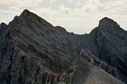
 View from the summit (10-09-2006)
Traverse from Sonntagskarspitze to Kaskarspitze
on the connecting ridge; UIAA grade III (parts) and easier; directly on the ridgecrest or through chutes on the southern side down to the connecting col; on the normal route up to Kaskarspitze; not recommended because of loose rock.
Traverse from Sonntagkarspitze to Hintere Bachofenspitze
on the connecting ridge; UIAA grade II and easier; directly on the ridge until you reach the steep summit block of Hintere Bachofenspitze; traverse up to the summit on the steep south side; loose rock and scree !
You can use scree filled ledges and slabs from east of Sonntagkarspitze summit down inti the upper Sonntagkar to gain the normal route up to Hintere Bachofenspitze; this descent is, too, not recommended for "normal" hikers because of the steepness and the loose rocks.
Red Tape
 Hintere Bachofenspitze and Roßkopf from Sonntagkarspitze summit (10-09-2006)
Sonntagkarspitze is part of a national park, the “Alpenpark Karwendel”.
There is no entrance fee for the park or any permit required. Nevertheless there are some reglementations.
Fires, Camping, noise and litter are prohibited within the park boundaries.
Do not pick up plants or parts of them.
Do not remove or disturb animals. Dogs must be leashed within the park.
Mountain biking is only possible on signposted routes.
Marked trails should not be left (though some interesting routes are off trail - routes; I never had difficulties with authorities within the national park but you should stick at least to the routes described in the Karwendel mountain guides).
Accomodations
In the surrounding valleys there are many accomodations, hotels, bed & breakfasts, camping. The following are only suggestions.Villages and Towns
Scharnitz
Innsbruck
Rum
Thaur
Hall
Mountain Huts
Pfeishütte
Halleranger HausBettelwurfhütte
Thaurer Alm
Möslalm
Maps and Guides
Map
Alpenvereinskarte, 1 : 25.000
Karwendelgebirge
- Nr. 5/1, Westliches Blatt
- Nr. 5/2, Mittleres Blatt
- Nr. 5/3, Östliches Blatt
Guide
Walter Klier
Alpenvereinsführer, Karwendel Alpin
Bergverlag Rudolf Rother
Weather Conditions
ORF Weather
Webcam Hafelekar cableway
Webcam to the south slopes of Karwendel