
-
 7955 Hits
-
 84.82% Score
-
 19 Votes
|
|
Mountain/Rock |
|---|---|
|
|
47.40404°N / 11.14962°E |
|
|
Hiking, Mountaineering, Scrambling |
|
|
Summer, Fall |
|
|
8100 ft / 2469 m |
|
|
Overview
 Öfelekopf as seen from Scharnitzjöchl
What a strange antagonism: Wettersteingebirge is a commonly well-known range, but most of the Wetterstein summits do not see many visitors.
There are highlights like Zugspitze, Alpspitze, Dreitorspitzen, Schachen; but who knows e.g.: Musterstein, Hochwanner, Großer Hundsstallkopf or .....
Öfelekopf ?
Öfelekopf stands high above the beautiful Leutasch valley, which is the southeastern limitation of the Wetterstein range. It is a twin peak with a height of 2469 m (Öfelekopf west) and 2479 m (Öfelekopf east), thus rising about 1400 meters above the valley floor. A huge limestone pyramid when viewed from the east, Öfelekopf is the southern limitation of the huge cirque named Leutascher Platt and the culmination point of the eastern ridge coming down from Leutascher Dreitorspitze.
Öfelekopf is separated from Dreitorspitzen by Söllerpass, a large and high col which allows the traverse from Puittal, south of Öfelekopf and Leutascher Platt / Bergleintal, north of the twin peak.
 Öfelekopf viewed from Leutasch valley
Öfelekopf Ost was first summited by Herrmann von Barth in august, 29th, 1871.
Öfelekopf West had to wait until 1895 (H. Gazert, L. Rieger)for the first summit ascent.
For me Öfelekopf west offers a great hike and a nice climb up to UIAA II+ / III- on the normal route (west ridge to west summit). With an ascent via Puittal and the descent via Leutascher Platt / Bergleintal you can do a more than satisfying loop.
Getting There
 Öfelekopf and west ridge spire as seen from Söllerpass ascent
Trailhead for the normal routes is Leutasch Reindlau, Leutasch Puitbach or Leutasch Lehner. All three villages are close together.
For the Bergleintal / Leutascher Platt route start at Leutasch Reindlau. There is a parking area behind the Hotel Hubertushof (if you pay a fee, which is a consumation bon for the restaurant, too, you can use the hotels parking area; there are still some free parking places alongside the forest road behind the hotel).
For the Puittal trail use the parking area at Leutasch Puitbach east of the road and north of the Puitbach bridge; the area is called "Chinesische Mauer" parking area.
There are no more parking possibilities at Leutasch Lehner, south of Leutasch Puitbach, alongside Lehner street! Nevertheless there is the trailhead ...
You reach Leutasch-Reindlau, Lehner or Puitbach
Route Overview
 Öfelekopf west, normal route overview
Öfelekopf west
Main routes
Normal Route Description
From Leutasch Reindlau / Hotel Hubertushof follow the forest road behind the parking area into the woods. Leave it to follow a trail bearing west and leading up the first steep slope. At a spring bear right on trail number 801 and traverse the lowest west slopes of Öfelekopf, slightly descending, to a level part of Bergleintal at the lower end of the impressive Bergleintal canyon.
Now the trail zigzags steeply up the northeast slopes of Öfelekopf (Stauden, Langegg, Schönegg) and reaches the lowest parts of Leutascher Platt, a huge limestone plateau with many interesting karst features.
Leave the trail 801 to your left where it starts to bear right at a height of about 1900 m. Follow the steep meadows and rock slopes south / southwest bound to the northern scree fields below Öfelekopf. You soon will see foot tracks in the scree fields. Follow them up to a huge outcrop of limestones, pass this outcrop on its left side and go on to the lowest point of the connecting ridge Leutascher Dreitorspitze - Öfelekopf. This is not Söllerpass, Söllerpass is about 80 m higher and west of that lowest point of the ridge (!)
 First slab after west ridge spire (II+) First slab after west ridge spire (II+) | 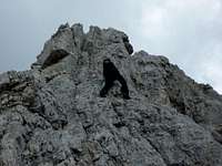 At the buttress (III-) At the buttress (III-) |  Upper chimney after buttress (II) Upper chimney after buttress (II) |
From Leutasch Puitbach or Lehner follow the signposts “Puittal” on forest roads. At the passage of Puitbach creek leave the forest roads and follow trail number 817 up the woods. You soon reach Puitegg and the lower meadows of beautiful Puittal.
After 5 minutes leave trail number 817 to the right at a signpost and follow trail number 818 up steep meadows (watch out for the red-white-red marks), through dense dwarf pines and up steep and rocky slopes to Söllerpass.
At Söllerpass leave the trail and follow the connecting ridge Leutascher Dreitospitze - Öfelekopf in eastern direction, descending to the lowest point of that ridge.
Summit route
The route starts ascending a meadow ridge up to a rock spire west of Öfelekopf. Climb up this tower in easy rock (UIAA grade I) until you nearly reach the top of that tower. Follow the cairns bypassing the tower summit to the left (north) or (more exposed) traverse the tower and descend to the cairn marked route.
East of that tower the route drops down steeply to a notch between the tower and Öfelekopf (UIAA grade I - I+).
 Upper slab (II) Upper slab (II) | 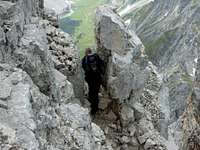 Upper notch / gap Upper notch / gap |  Traverse to buttress Traverse to buttress |
At the notch start climbing the steep rocks and a steep slab (UIAA grade II+ / III-) up to easier rocks and scree filled ledges and slopes. Follow these ledges and slopes in zigzags - there are cairns but the terrain is easy enough to find some alternative routes, too. The cairns are leading up to a rockface with a sort of chimney at its left limitation. Follow that chimney up to a towering rock, bypass that rock by leaving the chimney to the right, circling it and gaining the upper part of the chimney (UIAA grade I / I+).
Use the ledge to your left, follow that ledge (exposed and maybe slippery) to a steep but short rockface (UIAA grade II) which leads you up to a notch.
Don´t descend into the easy looking chute. Use the left, exposed looking buttress defining that chute to continue your climb, it starts at that notch. Climb straight up to a dihedral system. You can use both sides of the dihedral system to continue; the right one is easier (UIAA grade III-, exposed but delightful). At a second notch you can follow the short but steep arete (UIAA grade III). Alternatively traverse to the north side until you reach another chimney. Climb up that chimney (UIAA grade II) back to the arete.
 Upper chimney, descent Upper chimney, descent | 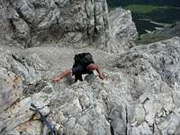 Buttress, descent Buttress, descent |
Follow the arete to a ledge leading into the south side of Öfelekopf. Traverse a little cirque on that ledge and climb up another chimney (UIAA grade I), through a rock gap and up to a third notch. From that notch climb back onto the arete (slab: UIAA grade I+) and follow the ridge / arete to the west summit.
Öfelekopf east
Red Tape & Accomodation
 Summit view from Öfelekopf west
No restrictions as far as I know.
Around Wetterstein range are many villages with accommodation of all kinds. The main villages are:
Leutasch
Seefeld
Telfs
Mösern
Scharnitz
Mittenwald
Garmisch-Partenkirchen
Around Öfelekopf there is only one mountain club hut offering food and lodging; the hut needs a 30 minutes detour from the main normal routes to Öfelekopf
Meilerhütte
Gear & Mountain Condition
 Öfelekopf Söllerpass and Leutascher Dreitorspitze (left)
Öfelekopf is a summer and autumn climb.
You should master rock difficulties up to UIAA II+ / III- in good and firm rock for the Öfelekopf west normal route. The route works without belaying; at the top of the buttress there is a good rock for belaying / rappelling down.
All the climbing routes and the traverse of the two summits (UIAA grade III, very exposed) is exclusively for the good climbers among us.
In autumn (and maybe in early summer) the northern traverse of the first rock tower may be icy and / or full of snow; this part can be very nasty then. If you are not sure about the condition in these times better bring an ice axe and crampons.
The hike up to Söllerpass respectively the Söllerpass traverse is an easy hike, a bit exposed below Söllerpass, though. Combined with a visit of Meillerhütte the Söllerpass traverse can make a satisfying day hike.
Current Weather
Maps & Guide Books
 Ascent to Söllerpass with Öfelekopf
Map
Alpenvereinskarte
1 : 25.000
Number 4/2, Wetterstein und Mieminger Berge, Mittleres Blatt
Deutscher Alpenverein
Guidebook
good route descriptions:
Alpenvereinsführer Wettersteingebirge
4th edition 1996
Bergverlag Rudolf Rother
(seen in the DAV - shop: www.dav-shop.de)