
-
 10244 Hits
-
 83.1% Score
-
 16 Votes
|
|
Mountain/Rock |
|---|---|
|
|
47.40067°N / 11.12430°E |
|
|
Hiking, Mountaineering, Trad Climbing, Mixed, Scrambling, Skiing |
|
|
Spring, Summer, Fall, Winter |
|
|
8799 ft / 2682 m |
|
|
Overview
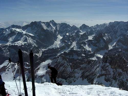
 Leutascher Dreitorspitze above Leutascher Platt (june 2010)
Within the high and rugged mountains of Wetterstein range there are two huge, plateau like karst features, high situated, large-scale cirques, surrounded with rock walls and challenging peaks: Zugspitzplatt, east of Zugspitze and the twin cirque, east of it: Leutascher Platt. Platt means flat and that is (in round terms) what it is: a high and inclined karst plateau within steep mountains lined up around it.
The highest peak of this Leutascher Platt border is Leutascher Dreitorspitze.
Leutascher Dreitorspitze is the southernmost peak of the whole of Dreitorspitzen, a chain of high summits where the Wetterstein main ridge deviates from its normal west - east orientation to a south - north - direction, thus bordering the west side of Leutascher Platt.
Neighbouring summits are Partenkirchener Dreitorspitze west summit to the north and Schüsselkarspitze to the west. The east ridge of Leutascher Dreitorspitze drops down to the Söllerpass col and culimates further east at Öfelekopf, thus building the southern limitation of Leutascher Platt.
To the south and the west Leutascher Dreitorspitze shows huge, steep and rugged rockfaces, the aspect from Leutascher Platt is more gentle with a steep summit block and two horn - like peaks. With dark clouds above the summit, Leutascher Dreitorspitze can look a bit like Barad-Dur, the fortress of bad Sauron in “Lord of the Rings”.
 Leutascher Dreitorspitze as seen from Alpspitze (april 2009)
Leutascher Dreitorspitze is not visited very often despite of its rank as highest peak of Leutascher Platt. Neighbouring Partenkirchener Dreitorspitze e.g. has a nice via ferrata, Hermann-von-Barth-Weg, a reminiscence to one of the most important opener of the Northern Limestone Alps to alpinism. The traverse of the four summits of Partenkirchener Dreitorspitzen (Signalkopf, northeast, middle and west summit) is a classic for good alpinists (parts UIAA grade III, the rest I to II) and is therefore done more frequently. Bayerländerturm, a bold spire near Dreitorspitzen is a classic climbing paradise. Our summit, however, has bad, loose and crumbly rock and - as normal route - a steep and unpleasant scree chute.
During spring times Leutascher Dreitorspitze sees a bit more visitors due to the excellent skiing conditions on Leutascher Platt. The scree chute then is a snow chute and after winter times with abundant snow you can start your ski descent some meters below the summit. But for your own safety you have to wait until all avalanche snow has come down from Öfelekopf north face; only then the ski route is really safe. This is nearly never earlier than april, which means: you carry your skies on your back for about 1 to 1,5 hours and for about 400 to 500 meters, starting from the valley. This little torture discourages many people. Therefore you will be (nearly) alone on this excellent lookout e.g. on a sunny day in may and you will easily find your private slope without any ski tracks from previous ski alpinists.
It is said that Ph. Rauth and H. Neuner from Leutasch valley summited first Leutascher Dreitorspitze 1857 while doing landsurvey. Yet this is not secured. The first touristic ascent was made by Hermann von Barth, 1871. He did a nice sketch of the mountain as seen from Leutascher Platt (see below).
 Sketch of Leutascher Dreitorspitze by H. von Barth (source Wikipedia; no copyright)
Getting There
 Leutascher Dreitorspitze as seen from Hohe Munde ascent (october 2009)
Trailheads for the normal routes are
Leutasch Reindlau,
For the Bergleintal / Leutascher Platt route start at Leutasch Reindlau. There is a parking area behind the Hotel Hubertushof (actually (2014) the hotel wants a parking fee which is a consumation bon if you choose to eat and drink something there; there are still some free parking places alongside the forest road behind the hotel!).
Leutasch Puitbach or Leutasch Lehner
For the Puittal trail use the parking area at Leutasch Puitbach east of the road and north of the Puitbach bridge, called "Chinesische Mauer".
At Leutasch - Lehner there are no more parking possibilities (2014). Nevertheless there still is the trailhead!
Garmisch - Partenkirchen, Elmau,
There is a parking area behind Hotel Elmau at the end of the Elmau road.
You reach Leutasch-Reindlau, Lehner or Puitbach
You reach Garmisch-Partenkirchen / Elmau
All trailheads can be reached with railway and busses, too, but this is quite difficult, takes a lot of time and depends on seasonally schedules. Please refer to the internet for this case to get the up-to-date - schedules and links.
Routes Overview
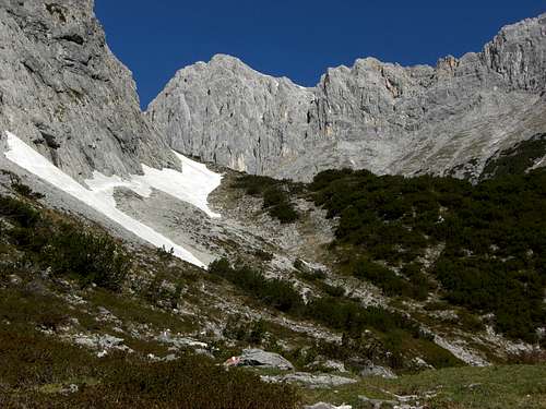 Bergleintal trail with Musterstein (may 2011)
Bergleintal trail:
Start at Hotel Hubertushof. Follow the forest road and then (signposts Meillerhütte) a trail in northwestern direction. Turn right at the trail junction with trail number 801 coming from Leutasch Puitbach (use that trail when parking at Puitbach and ascending via Bergleintal trail).
Follow that trail to Stauden, Langegg, Schönegg until you reach the lower end of Leutascher Platt. Trail number 801 traverses to the north rim of the Platt and ascends below the southern rockfaces of Musterstein and Törlspitzen (passing by an alm hut) to the scree field leading up to Meillerhütte.
At the trail junction with trail number 818 to Söllerpass col turn left and follow that trail to the middle part of Leutascher Platt. Leave the trail there and aim off trail in the direction of the summit of Leutascher Dreitorspitze until you reach a huge karst sinkhole below the summit block of Leutascher Dreitorspitze. Fight yourself up the scree field and the scree chute to the col between summit and northern subsummit and follow the exposed north ridge to the summit.
Ski route:
The ski route is the same like Bergleintal trail until you reach the lower end of Leutascher Platt. Don´t traverse the Platt there, go straight on to gain the sinkhole and the summit chute. Downhill is the same route. The chute has about 35 - 40 degrees of inclination and some narrow parts.
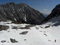 Upper Leutascher Platt ski area (may 2011) Upper Leutascher Platt ski area (may 2011) |  Ascending Leutascher Platt to the summit (may 2011) Ascending Leutascher Platt to the summit (may 2011) |  Downhill below the summit chute (may 2011) Downhill below the summit chute (may 2011) |
Puittal trail:
From Leutasch Puitbach or Lehner follow the signposts “Puittal” on forest roads. At the passage of Puitbach creek leave the forest roads and follow trail number 817 up the woods. You soon reach Puitegg and the lower meadows of lovely Puittal.
After 5 minutes leave trail number 817 to the right at a signpost and follow trail number 818 up steep meadows (watch out for the red-white-red marks), through dense dwarf pines and up steep and rocky slopes to Söllerpass.
At Söllerpass take the upper - left - trail in the direction of Partenkirchner Dreitorspitze. Where this trail gets a more northwest direction, leave it to gain the huge sinkhole in western direction and ascend the summit chute to the col and the summit.
 Leutascher Dreitorspitze (left) and Söllerpass (june 2010) Leutascher Dreitorspitze (left) and Söllerpass (june 2010) |  On the way to Söllerpass (june 2010) On the way to Söllerpass (june 2010) | 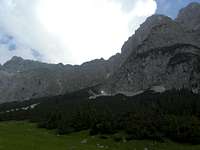 On the way to Söllerpass (june 2010) On the way to Söllerpass (june 2010) |
Schachen - Meillerhütte trail:
From the parking area at Elmau follow the forest roads to Schachenhaus with the Schachenschloß of Bavarian King Ludwig II. Trail number 801 leads you up to Meillerhütte.
Alternatively follow the trail passing Wettersteinalm to Schachentor and Schachenhaus.
From Meillerhütte follow the trail to Partenkirchener Dreitorspitze / Herrmann-von-Barth-Weg in southern direction, first descending, then traversing the Bayerländerturm. Where the marked trail ascends steeply to the beginning of the via ferrata leave it and go on off trail in southern direction until you reach the sinkhole and the summit chute for the summit ascent.
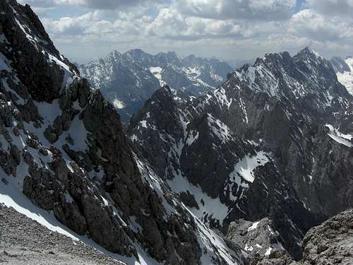
 Öfelekopf and Leutascher Platt as seen from the summit (may 2011)
Angerlloch - Meillerhütte trail:
Follow the Schachen - Meillerhütte trail until you reach a clearing in the woods with Wetterstein Alm. Leave the forest roads there, pass by Wettersteinalm and follow the trail ascending in the direction of Schachentor. At a trail junction with some red signs on a huge block follow the left narrow trail up to Angerlloch. This is a spectacular ascent below the threatening northern rock faces of Musterstein, Hirschbichlkopf and Törlspitzen. The route needs some rock scramble up to UIAA grade I, more difficult parts are secured with steel ropes, but pay attention: avalanches, thunderstorms and falling rocks can have damaged these ropes easily so you might get tested with UIAA grade II to II+ !!
At Angerlloch, an impressive sinkhole below Musterstein, turn right and ascend on the trail up to Frauenalpl below Meillerhütte, where you reach trail number 801 coming up from Schachen. Go on as described for the Schachen - Meillerhütte trail.
Climbers routes and ridge routes:
Despite of the famous neighbouring Schüsselkarspitze with its many classic climber routes Leutascher Dreitorspitze does not have wellknown climbing routes. The Wetterstein alpine club guide book names:
Red Tape & Accomodation
 Musterstein (left) and Leutascher Dreitorspitze as seen from Estergebirge (april 2011)
No restrictions as far as I know.
Around Wetterstein range are many villages with accommodation of all kinds.
The main villages are:
Leutasch
Seefeld
Telfs
Mösern
Scharnitz
Mittenwald
Garmisch-Partenkirchen
Near Leutascher Dreitorspitze Meilerhütte offers food and lodging.
Climbers on the arete between Schüsselkarspitzen and Dreitorspitzen can use the Schüsselkarspitze bivouak (6 places, open all year).
Gear & Mountain Condition
 Near the summit - gorgeous views to Wetterstein and Mieming range (may 2011)
Leutascher Dreitorspitze is - nearly - an all seasons summit.
In summer and autumn it is a long and difficult hiking tour with off-trail parts and a steep scree chute. The summit block needs some easy rock scramble on an exposed ridge. Good hiking gear, enough water (karst !) and some mountain experience can do no harm.
In winter Leutascher Dreitorspitze normally is too dangerous as a ski tour. The avalanche danger in Bergleintal is very high. You should be very aware of the avalanche situation when planning a winter ascent.
The situation ameliorates in spring when the avalanche snow of the Öfelekopf north slopes is down in Bergleintal and can consequently be used for ascending and skiing down.
In winter and early spring you need full avalanche gear; full ski tour equipment is obligatory. I recommend avalanche gear in late spring too; depending on the situation you might not use it.
Leutascher Dreitorspitze is a long but not a difficult ski tour. The summit chute can be skied down but be aware of the steepness (about 40 degrees) and the narrow parts of the chute.
Check the Tirol avalanche bulletin here.
Current Weather:
Map & Guide Book
MapAlpenvereinskarte
1 : 25.000, UMT - grid
Number 4/2, Wetterstein und Mieminger Berge, Mittleres Blatt
Deutscher Alpenverein, edition 2007
 Ski ascent at the summit block (may 2011) Ski ascent at the summit block (may 2011) |  Leutascher Dreitorspitze (left) as seen from Kuhflucht trail to Hoher Fricken (april 2011) Leutascher Dreitorspitze (left) as seen from Kuhflucht trail to Hoher Fricken (april 2011) |
Guidebook
Alpenvereinsführer Wettersteingebirge
4th edition 1996
Bergverlag Rudolf Rother
(seen in the DAV - shop: www.dav-shop.de)