
|
|
Mountain/Rock |
|---|---|
|
|
47.44496°N / 11.04859°E |
|
|
Hiking |
|
|
5968 ft / 1819 m |
|
|
Overview
The Schwarzenkopf is a little known mountain in the Northern part of the Wettersteingebirge in the Bavarian Alps, Germany. Little known but one well worth hiking up from near the town of Garmisch-Partenkirchen which is to it’s North East. Mention of Garmisch-Partenkirchen is a clue as to why such a worthwhile hiking mountain as the Schwarzenkopf should be little known! It sits, literally, in the shade of the Alpspitze, the Jubiläumsgrat and Germany’s highest mountain, the Zugspitze, whose hiking and climbing potential is very well known to hikers, mountaineers and climbers from a lot further away than Germany.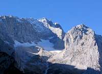 Zugspitze and Glacier
The Schwarzenkopf is purely a hiking mountain. With one particularly interesting route from Hammersbach that embraces the lovely Höllentalklamm, (a deep gorge), and great views of the Zugspitze and it’s Northern glacier. It is in an area well commercialised as it is not far from the North facing slopes that have become world famous as Garmisch-Partenkirchen’s ski slopes. With all the ski lifts, cable cars and huttes that activity embraces. Thankfully the best hiking route up meets none of that!
Getting There
Hammersbach, which is little more than a very small halting point, (not even big enough to be called a station!), for the Zugspitze narrow gauge railway that runs from Garmisch-Partenkirchen up to the Zugspitze is the best starting point, although there are routes from directly South of Garmisch-Partenkirchen. Hammersbach is just a few kms West South West of the main town center. Garmisch-Partenkirchen itself is just 88kms South of München, (Munich), by road on the A95 Autobahn, leaving that at Eschenlohe. From there it is the B2 then B23 main roads into town. From there follow B23 through to the Western edge of the town and after passing the turn off to the Kreuzeck and Osterfelderkopf cable car stations take the next road on the left which soon crosses the main German Rail railway line to Austria. A right turn follows quickly and then soon turn left and a hikers car park is on the right, just before the road crosses the Zugspitze narrow gauge railway. A nice mountain hiking track
From München Airport catch the S1 or S8 mass transit system trains into the main station, and that takes about forty minutes. From there an hourly service on the main German rail system runs to Garmisch-Partenkirchen from early until late. With a half hourly service in the peak hours. Journey time around ninety minutes.
From Garmisch-Partenkirchen railway station to Hammersbach either take the Zugspitze narrow gauge railway, (West side of the station), or catch the mainly hourly service of the Weisse Blaue, (White Blue), Eibsee bus service from near the station. For this leave the railway station to the East, turn North for a few paces and then cross the road. The bus stop is just a few more paces along the road to the North. Buses to the Alpspitze and Kreuzeck cable cars also leave from the same bus stop. Don’t go into the bus station almost opposite the East side of the station. That is for the Regional Buses, (RVO), which don’t serve either Hammersbach or the cable car stations. But they are excellent buses for getting to mountains further away from the locality of Garmisch-Partenkirchen.
Red Tape
There is no real "red tape" for the routes to the Schwarzenkopf.But like all Alpine areas it is always best to leave as little sign that you have been there as possible. Disturb nothing, leave nothing behind and take only photos. That maybe describes what virtually all of us who walk in such places do as a normal routine.
Camping
The general rule for the area so far as camping away from any organised facility is, "Bivouacking tolerated, camping discouraged". But due to the nature of the best route, (from Hammersbach), there are few locations where discrete camping is possible due to long sections on a narrow ledge!When to Climb
 Autumn can be the best time
June to October, maybe into November depending on when the snows arrive, if using the best route which is from Hammersbach and through the Höllentalklamm. Not a route to use in the winter snows because of avalanche risk. The direct route through the Höllentalklamm can shut from mid October until late Spring, but there is an alternative track that climbs above the Klamm.
It may well be possible to get to the Schwarzenkopf in winter using the route directly South from Garmisch-Partenkirchen.
See under Routes for more information.
Where to Stay
Garmisch-Partenkirchen has a very wide range of places to stay. From the simplest of bed and breakfast accommodation in Gasthofs up to large, (and expensive) hotels! The tourist Information service has an online system for you to find accommodation in your price range, (see links).If you prefer staying in a village local to the town, many of those also have a good range of accommodation: usually cheaper than in the town! A GOOGLE search under the village name will show those that have their own village websites. And many of these sites will also an accommodation list.
Maps
 Nice view to the North
DAV, (German Alpine Club), 1:25000 map series, No. 4/2 Wetterstein- und Mieminger Gebirge
Bayerisches Landesvermessungsamt München Topographische Karte 1.25000 series. No. 8532/8632 Garmisch-Partenkirchen.
Kompass WK 5 Wettersteingebirge-Zugspitzgebiet 1:50.000 ISBN: 3-85491-007-X
Kompass No.790, Garmisch-Partenkirchen Mittenwald 1:30.000. ISBN 3-85491-581-0
Useful LInks
Garmisch-Partenkirchen's tourist information siteEnglish version.
Where to Stay
The town's own on line system that helps you to find overnight accommodation.
Local Town Bus Timetables:
All on down loadable PDF files
RVO Bus Timetables
This link should get you to the Garmisch-Partenkirchen page. In the center click on the box in the center, (under the box with "Garmisch-Partenkirchen" in it. This has the words, "Bitte Fahrplan auswählen" in it. That then gives you a choice of the routes to click on. Following which a down loadable pdf file gives the timetable for the route.
Weiss Blaue Bus Timetable
A pdf file giving the times of the Weiss Blaue buses from Garmisch-Partenkirchen out to Hammersbach and Eibsee.
Train Times
Use this to get timetable information for your journey by German Railways, (DB). This link takes you to an English language page.
Weather forecast
I've found this to be quite a reliable weather forecasting service
Webcam
And to see the actual weather have a look at the Jubiläumsgrat and other mountains immediately South of Garmisch-Partenkirchen. The Schwarzenkopf is down from the skyline and about one third of the way in from the right.
Weather data
Read the actual weather data for Garmisch-Partenkirchen.
Local maps
This Garmisch-Partenkirchen shop, (only ten minutes walk from the main railway station), keeps a good stock of guide books and general tourist type maps, plus the DAV, (German Alpine Club), maps and just a few of the elusive Topographische Karte 1.25000 maps that cover areas not included in the DAV series.
Avalanches
Details of avalanche levels is displayed by this site in the winter months.
Zugspitzbahn
Timetables for the narrow gauge, (cog wheel), train to Hammersbach and the Zugspitze, and also for the main cable car operations.
Höllentalklamm
Covers the scenic Höllentalklamm, (gorge), including some information on when it is open/closed during the year, (in German).
Arthur Digbee - Aug 4, 2008 2:05 pm - Voted 10/10
thanks!Great page, Bryan, and your directions are spot-on. I should also note that if you're staying at the end of Garmisch nearest the mountains, as I was, it's a 30-minute walk up to the Hammersbach Halt. Depending on schedules, you might get there faster than the train (I did).