Introduction
Given that I spend about 70 hours every week behind a desk, my definitions for words like “epic” are, by necessity, relative. Otherwise I would never have epics of my own because—let’s be honest—there’s only so much adventure to be found staring at a 16-inch monitor all day.
In other words, my epic might not be your epic. It is with this qualification that I tell the story of my last epic, the Four Pass Loop.
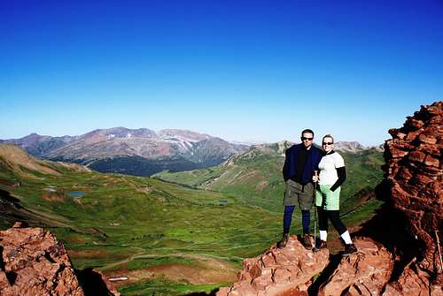
The Four Pass Loop is wonderful little hike outside of the wonderful little town of Aspen, Colorado. Not to be confused with Hollywood, Aspen is actually a ski town with several fine mountains, namely Ajax and Aspen Highlands. Down the road a bit is a quaint roundabout designed to make Aspen look even less like Hollywood and more like a European ski village. Radiating southwest from said roundabout is a road of ten miles or so which leads to the perpetually crowded but strikingly beautiful Maroon Lake which reflects “the most photographed mountains in [insert one: the lower 48, North America, the Western Hemisphere, the Universe], the Maroon Bells. To be sure, the “Bells” are beautiful and although I had seen them plastered on many a postcard and fourteener calendar, I couldn’t help but feel the wonder of seeing them up close in three dimensions.
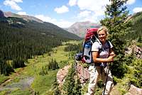
The name “Four Pass Loop” gives much information about the route. First, it crosses four mountain passes, in this case each above 12,400 feet, which suggests that the views are stunning. Second, it is a loop, which many would say is the most aesthetic type of hike, requiring both no car shuttle and no backtracking. (As a side note, an actual hike of the loop would later confirm what the name suggests: the loop is aesthetically stunning). Our party--my girlfriend Megan, good friend Eric (Summitpost member ericb), his girlfriend Liz and myself--began the Four Pass Loop at Maroon Lake. However, one can also access the loop from Snowmass Creek on the north side of the Elk Range and from Lead King Basin or Schofield Pass on the south side of the range, although the hike from Maroon Lake makes for the shortest Loop (24-29 miles, depending on who you ask and which variations you take).
![Four Pass Loop]() Our Route. Blue boxes are mileage markers.
Our Route. Blue boxes are mileage markers.
Total Distance: ~25.4 miles
Cumulative Elevation Gain / Loss: ~7,400 feet
Day 1: Maroon Lake to Upper West Maroon Basin
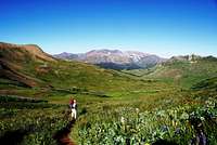
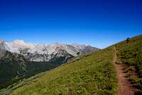
From Maroon Lake, we hiked south along West Maroon Creek to Crater Lake at the very foot of the Bells. Light gray clouds blanketed the valley just high enough to reveal the guiding handrails of the Pyramid Peak massif on our left and the Maroon Massif on our right.
![West Maroon Valley: Green and Moist]() West Maroon Valley: Green and Moist
West Maroon Valley: Green and MoistWisps of fog hung lazily lower in some spots; subtle accents on God’s canvas. We had hoped for a sunny day, but we all agreed that the clouds added new texture and character to mountains that already had plenty of both.
Rain came three hours into our trip. We happened to be hiking through an island of trees in the slightly-above-treeline zone, so we took cover for conversation and a good cigar. “There is no place I’d rather be,” I thought. When the rain left, so did the clouds, and we foolishly celebrated as if success were assured.
![Texture on the Pyramid Massif]() Texture on the Pyramid Massif
Texture on the Pyramid Massif![The King of the Upper West Maroon Basin]() The King of the West Maroon Basin
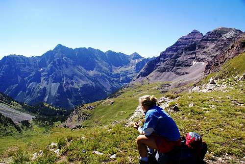
The King of the West Maroon Basin(Success, in this context, meant coming directly from sea level and hiking over two of the passes on our first day. This would involve roughly 11 miles of hiking and 3,500 feet of climbing on four hours of sleep. Two nights prior, Megan and I had taken a red eye from Maui to Denver; Eric and Liz are parents of three who reside in the suburbs of Boston--elevation, ~10 feet). So we didn’t make it to our planned destination, two passes away in Fravert Basin. In fact, we didn’t make it over the first pass, West Maroon. We called it a day early, high in the West Maroon Basin, with the pass an arm’s length (~1 mile) away. The new plan was to sleep long and deeply and be transformed into well-rested machines for the 13 mile, 4,000 vertical foot hike to Snowmass Lake on Day 2. I should probably mention that this loop is best done in 4+ days, but for a number of reasons, we had only three.
After a hearty meal of re-hydrated chili, we retired at 8 PM meaning that a 5 AM wake-up would afford us 9 hours of sleep. While Liz and Eric had smartly pitched their tent in a brush clearing, Megan and I made home on a wide, flat patch of grass which happened to be the preferred dining establishment for the Upper Maroon Valley’s resident 8-point buck. In consistent five minute intervals between 8 PM and 1 AM, this very large animal made feeding visits to our tent, occasionally sticking its nose in the vestibule to inhale fumes from the finely-ground coffee I had forgotten to remove from my backpack. We barely slept.
Day 2: Upper West Maroon Basin to Snowmass Lake
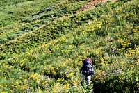
![West Maroon Colors]() West Maroon Colors
West Maroon Colors![West Maroon Basin]() Upper West Maroon Basin
Upper West Maroon Basin![West Maroon Basin Wildflowers]() More Colors
More Colors
Instead of waking re-invigorated for the long Day 2, Megan and I stumbled from our tent into the pre-dawn darkness, groggy and grumpy. Eric and Liz had already decided to head down the valley back to the trailhead. Joining them sounded like a great idea. It’s amazing what happens to one’s morale, though, when the sun rises over the easterly ridges on a cloudless day and flushes the valley with warmth. Inevitably, one gains fortitude and the belief that he can continue. And so it was for Megan and me, and we elected to go through with the plan. Following oatmeal and coffee, off we went. Eric and Liz were to join us for the initial climb to West Maroon Pass and would then turn back. In what would become a theme for the day, my physical exhaustion was tempered just enough by the inspiring beauty of the Elk Mountains.
![Eric and Liz On West Maroon Pass]() Eric and Liz on West Maroon Pass
Eric and Liz on West Maroon Pass![West Maroon Valley]() West Maroon Valley from West Maroon Pass
West Maroon Valley from West Maroon PassExpansive views of the East Fork Basin
![East Fork Basin]() East Fork Basin
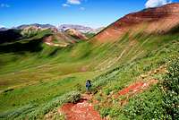
East Fork Basin and West Elk Mountains greeted us at West Maroon Pass. After snapping a few photos and saying goodbye to Eric and Liz, Megan and I continued south over the pass. Walking through the East Fork Basin was surreal: an unusually wet summer had produced a carpet of lush green vegetation punctuated by the intense reds, yellows and purples of summer wildflowers. Yet on that particular day, the frequent summer rain was nowhere to be found.
![West Maroon Pass to Frigid Air Pass]() En Route from West Maroon to Frigid Air
En Route from West Maroon to Frigid Air
At the first trail junction below the pass, we took the right fork and contoured northwest for ~1.5 miles to a second trail junction, the left fork of which leads to Hasley Basin.
![Frigid Air Pass]() Ascending Frigid Air Pass
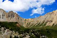
Ascending Frigid Air PassWe continued right and began the steep climb to Frigid Air Pass. Maroon Peak, which had been invisible from the East Fork Basin, reappeared at the summit of Frigid Air Pass.
![Maroon Peak From Frigid Air Pass]() Maroon Peak from Frigid Air Pass
Maroon Peak from Frigid Air PassStopping only for a picture, we quickly descended into Fravert Basin,
![Fravert Basin]() Fravert Basin
Fravert Basinan amazing place which nicely typifies the diversity of terrain encountered in Colorado’s mountains. The hike down the valley felt long, and fatigue began to worsen. At the first established campsite, we stopped for lunch: peanut butter and banana chip sandwiches. While incredibly tasty, peanut butter is not the best food for a long hike on a dry, hot day. I think I burned as many calories trying to dislodge the stuff from the roof of my mouth as I gained digesting the sandwich.
A five-minute hike from our lunch spot led us to the top of an impressive cascade.
![North Fork Basin]() North Fork Basin
North Fork BasinHere, the Crystal River’s north fork decides that it’s had enough of its lazy, slow course and plunges 300 feet to the valley below.
![North Fork Cascade]() North Fork Cascade
North Fork CascadeThe steep hike to the base of the waterfall follows five or so switchbacks through dense pines. The trail emerges from the trees then passes near a mineral-saturated tarn and re-enters the woods. And then it starts uphill. “We’re not supposed to be going uphill until we cross the river,” I thought. Normally I don’t mind undulating trails, especially in such a beautiful setting, but I was exhausted and began complaining to Megan who, quite tired herself, was more than happy to reciprocate.
We exited the trees and, thankfully, resumed our downhill trend. After a few minutes, we rejoined the trail from Hasley Basin and a quarter mile later reached the banks of the North Fork, which would be our only shoes-off water crossing of the entire trip. Needless to say, the water was freakishly cold, but at least it woke us up. Now on the river’s north side, we continued mostly west for about ¾ mile to the turnoff for Trail Rider Pass. This was the climb we had been mentally preparing for all day.
![Treasure Mountain]() Treasure Mountain and Lead King Basin
Treasure Mountain and Lead King BasinAs we started up, I remembered the jubilance we all felt upon waking to a clear sky earlier that morning and contrasted it with the not-so-jubilant experience of hiking up a steep, shadeless, south facing slope under a clear sky in the middle of the afternoon.
![Megan Forces a Smile]() Megan Forces a Smile
Megan Forces a SmileIt was brutally hot, but occasionally a few leaves from an Aspen would block 1% of the sun’s light, making it only 99% brutally hot. (Another side note, to save myself from the embarrassment of sounding like a wimp: I was still loving every minute of this, and most to whom this account will appeal can probably identify with that strange feeling of being—-not in excruciating pain-—but at least uncomfortable and tired but yet loving it and wanting to be nowhere else).
After an hour of hiking, we reached another trail junction. The left fork traverses the hillside west to Geneva Lake (if only we had more time...), but this being a clockwise loop, we took the right fork which bends around to the East. At a stream crossing five minutes ahead, we encountered a man who looked like he knew the area well. “Where are you headed,” he asked. “Snowmass Lake,” I answered in fatigued monotone. “Jeez; well, it’s 3 o’clock. That’s not exactly inhuman, but it’s a long haul from here,” he said. My blank stare didn’t change as I mumbled, “thanks, have a good hike.” As it would turn out, we weren’t really as far from the lake as this gentleman made it sound, but his weren’t the most inspiring words one could hope to hear.
Twenty minutes up the path, Trail Rider Pass came into view. A party of
![Trail Rider Pass]() Trail Rider Pass
Trail Rider Pass![Below Trail Rider Pass]() Surveying the Landscape Below Trail Rider Pass
Surveying the Landscape Below Trail Rider Pass10 was descending the pass and upon seeing the relatively large profiles of its members, Megan remarked, “it doesn’t look that far.” Good news. Upon closer inspection, each member of the party was dressed in brown. Upon even closer inspection, each member of the party was actually a horse and the pass wasn’t as close as we had initially thought.
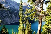
The trail descended 200 feet or so from this point and passed a lake and some fir stands which would be the last decent campsites before Snowmass Lake. We passed said horses (or they passed us) and we began the climb to our third and final pass of the day. It was slow going, and I had ample time to contemplate such topics as “how does a horse make it down a 35 degree slope without falling?” In any event, after putting one foot in front of the other for a while, there we were at the pass with large views everywhere, including the amazing emerald, Snowmass Lake.
![Snowmass Lake From Trail Rider Pass]() Snowmass Lake from Trail Rider Pass
Snowmass Lake from Trail Rider Pass
We should have learned from looking at the horses that judging distance based on the perceived size of an object can be misleading. From Trail Rider Pass, Snowmass Lake looked close. It turned out not to be so close
![Between the Trees: Snowmass Lake]() Through the Trees: Snowmass Lake
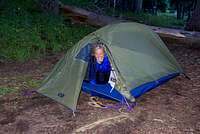
Through the Trees: Snowmass Lake![1.5 Person Tent]() Our 1.5 Person Tent
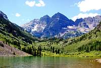
Our 1.5 Person Tentand 90 minutes later, we struggled into camp after eleven hours of hiking, tired and hungry. Notwithstanding the crowds, Snowmass Lake is an outstanding campsite. Perched just below treeline, the camp provides excellent views of the Snowmass Mountain massif, the creek and waterfall which eventually join Snowmass Creek and of course, the lake itself. Our camp was constructed next to the stream that drains the lake and the serene beauty of the place quickly restored us (or maybe it was dinner). We retired early, hoping for a deer-free night’s sleep.
Day 3: Snowmass Lake to Maroon Lake
Day 3 began much as the previous day had: crisp and cloudless. I awoke just in time to witness the sun’s rays striking the tops of Snowmass and
![Snowmass Mountain]() Snowmass Mountain
Snowmass Mountain![Snowmass Lake]() Snowmass Lake Reflection
Snowmass Lake ReflectionHagerman and attempt what can only be described as the perfect reflection shot. Unfortunately my sub-amateur photography skills produced nothing like what I actually saw, but such is life.
We began hiking after a leisurely breakfast. A quarter mile from the lake, the trail reached a junction with the Snowmass Creek trail. We continued east and then southeast for about a mile until we reached the broad valley of Snowmass Creek proper where the work of the beaver is readily apparent. We crossed Snowmass Creek on a pair of unstable logs and after following the creek for a few more minutes, began the climb to
![Snowmass Creek Valley]() Snowmass Creek Valley
Snowmass Creek Valley![Elk Range Magic]() Elk Range Magic
Elk Range MagicBuckskin Pass. The trail initially climbs gradually through the woods then reaches a clearing and climbs more steeply. Views to the West here of the ridge dividing the North Fork valley from the Snowmass Creek valley are impressive. At ~11,600 feet, we reached timberline in the basin directly below Buckskin Pass. The trail initially heads directly east toward the pass but then veers south as the basin steepens and then becomes switchbacks. At ~12,200, the trail graciously relents and traverses far to the North, then turns south one final time. The last leg leading to the pass is long and gradual.
![A Well-Deserved Snack]() A Well-Deserved Snack at Buckskin Pass
A Well-Deserved Snack at Buckskin Pass
Buckskin Pass brought the mixed emotions of accomplishment on the one hand and, on the other, disappointment that our epic was nearing its end. It also brought spectacular views of the Pyramid Peak massif, North Maroon, Snowmass and Capitol peaks. We stayed on the pass for a while, soaking in the moment. I took note of the fact that I hadn’t seen a threatening cloud since Day 1; we were very lucky.
Shortly after beginning our descent into Minnehaha Gulch, we were passed by two runners coming up the trail, serving us lowly hikers a healthy dose of ego deflation. At the Willow Pass Trail junction, we again took the right fork. At this point the desire to continue hiking through the awesome Maroon Bells-Snowmass Wilderness became overshadowed by the desire to get to the car. Soon, the overused trail deteriorated into a rubble gully. An hour after the Willow Pass junction, we reached Crater Lake. The ~1.75 miles from Crater Lake to Maroon Lake were spent walking silently staring at the ground, offering “hellos” to countless passing hikers only when prompted.
The tourism circus aside, Maroon Lake was a welcome sight as were our dear friends Eric and Liz, who had experienced their own epic hiking out from
![Requisite Bells Shot]() Requisite Bells Shot
Requisite Bells Shotthe West Maroon basin. We asked an older couple if they wouldn’t mind taking a picture of the four of us with the lake and Bells in the background. They grudgingly agreed. “Just press the button halfway down to----,” Eric said to the man. “Oh, he knows,” snapped the man’s wife. Well, he may have known how to focus the camera, but this guy evidently decided that the Maroon Bells and Lake were optional items in the photo so we were left with a shot that I could’ve taken in my backyard. Moron.
In Closing
At the Denver airport the next day, Megan and I bid farewell to Eric and Liz. They were on a redeye to Boston (Eric had to work the following morning); we were on a flight to Vermont for a two-day wedding trip, then back to San Francisco—back to the rat race.
Every so often I question my desire to go walk around in the mountains; I consider the effort required in planning and organizing. And those are the things I
can control. Throw in the weather, various carnivores, microbials and other indiscriminate risk factors and a trip to the woods can rapidly turn sour. This trip didn’t work exactly as planned, but everything worked out, reminding me why I go to the wilderness to begin with: to escape structured normalcy and be surprised by places that are much, much larger than me.
Related Pages
Four Pass Loop Album
External Links
Maroon Bells - Snowmass Wilderness
Elk Range Trail and Road Conditions from the Forest Conservancy
GORP Trail Description


Comments
Post a Comment