Preface
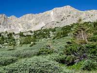
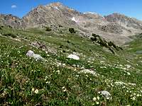
![Tabor Peak]() Tellurium from Larson
Tellurium from Larson
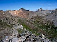
Unnamed Peak 13300 ft (Tellurium Peak) sits at the southwestern end of Tabor Creek Valley in the Collegiate Peaks Wilderness of Central Colorado near the town of Aspen. I had first seen this peak in August of 2009 from the summit of the nearby
Larson Peak. From that angle, it seemed like Tellurium Peak could be climbed without any significant difficulties. Ormes’ “Guide to the Colorado Mountains” said that a trail went from Lincoln Creek Road to a (12460 ft) saddle at the southern end of Tabor Creek Valley. From there, the book said “you can go west up a ridge to the crest, then scramble 300 ft northwest to grab Peak 13300 ft”.
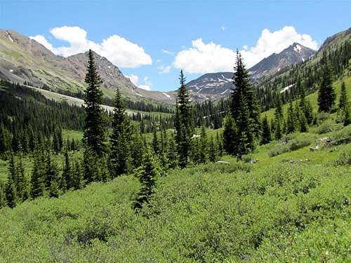
![Tellurium & Tabor Creek Valley]() Tellurium (2nd from right) & Tabor Creek Valley
Tellurium (2nd from right) & Tabor Creek ValleyStatistics
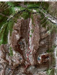
![Map]() Map
Map 10250 ft
Goal: UN 13300 ft (Tellurium Peak)
Maximum Elevation Reached: 13110 ft
Roundtrip Hiking Distance: 8.71 miles
Tuesday July 6, 2010
My cousin Chris and I left Snowmass Village at 5:30 a.m. We took Route 82 east, went through Aspen and continued east until we reached the junction of Lincoln Creek (dirt) Road. The 4.1 mile drive to the Tabor Creek Trailhead on that pothole ridden road took us 40 minutes. I hate that road.
The sun was still behind the mountains and the vehicle’s thermometer read 30 deg F. We knew that our first task would be to cross Lincoln Creek. The thought of getting wet in that cold weather made it much harder to get out of the vehicle.
We started to hike at 7:00 a.m. (elevation 10250 ft). We did not see a single person all day long. There were a couple of logs over Lincoln Creek to help us cross. The water level was low anyway and we were able to cross without any difficulties. It seemed like much of the creek’s flow was diverted into the aqueduct at Grizzly Reservoir upstream.
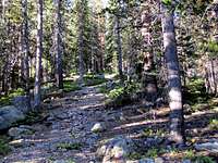
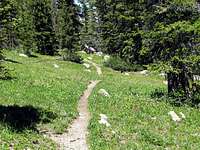
The trail went into a pine forest and went uphill steeply. After 0.4 miles ,we reached the aqueduct road (10580 ft). The trail crossed to the other side of the road and continued uphill thru the forest parallel to Tabor Creek.
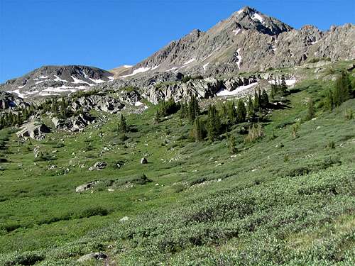
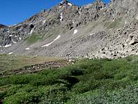
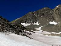
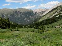
As we went higher, it became less steep and the Tabor Creek Valley began to appear in front of us to the south. It was a long, broad and U-Shaped valley. I have not read anything about the geology of the area but I could imagine how in the distant past, the valley might have housed a giant glacier. Tellurium Peak came to view at the southwestern end of the valley. It had nasty slopes that were covered by cliffs and steep scree but I did not care because I wanted to climb it via its southeastern ridge-top which could not be seen from that angle.
![Tellurium Peak]() Tellirium Peak
Tellirium Peak![Avalanche Remains]() Avalanche remains
Avalanche remains![Avalance Remains]() Avalanche remains
Avalanche remains
The trail then crossed to the west side of the creek (we just hopped over the rocks) and continued south on the west side of the valley. We were now at around 10800 ft elevation. The forest had ended. The slopes above us did not have any trees at all. I could see giant avalanche remains at the bottom of the valley over the creek. I was thinking that these slopes were probably bare due to repeated winter avalanches. We then reached one large patch of snow that covered the trail and was quite steep. The snow was still in the shade and was very hard. Fortunately, there were foot prints in the snow that allowed us to traverse it safely.
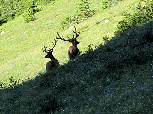
Chris lives in the San Jose area and has done much hiking in the coastal mountains of California. He kept talking about incidents of mountain lion attacks in California. In a few places, he saw what he identified as mountain lion paw prints. At the trailhead, we had seen signs about bears but nothing about mountain lions. As we were talking about the lions, we suddenly saw a few large animals in the distance. They turned out to be just a couple of Elk (or whatever they were).They stood there staring at us. Once we began to move, they ran away.
![On Tabor Creek Trail]()
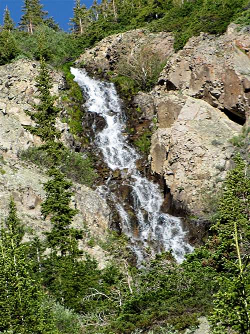
As we kept going, pine trees appeared around us again. After 2.1 miles (11400 ft) we reached a creek that came down the western wall of the valley and made a beautiful waterfall on the slopes above us. I knew that must have been the creek that drains Tabor Lake which sits up the slopes at an elevation of 12300 ft at the base of the Unnamed 13282 ft (Tabor Peak). I had read that a faint side trail went up to that lake but I did not find any sign of that trail anywhere.
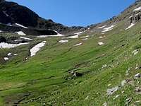
We then reached a place where the trail went straight up steep slopes at the bottom of the valley. My maps indicated that after a 2.8 mile hike, we were supposed to reach a lake. I was certain that the lake was at the top of the steep slope.
![Steep slopes before the lakes]() Steep before the lakes
Steep before the lakes
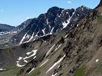
Once we reached the top of the steep slope (11800 ft), we saw no sign of a lake (we actually found the lake on our way back later in the day). The trail faded away too. A big grassy valley sat in front of us to the south. We were now much closer to tellurium Peak which sat at the southwestern end of the valley. Across from Tellurium, there was a rocky peak at the southeastern end of the valley. That must have been the 13140 ft West Truro Peak. The 12460 ft grassy saddle could be seen between Tellurium and West Truro.
![Tellurium Peak]() Tellurium Peak
Tellurium Peak
I could also look to the west and northwest to see the impressive 13282 ft Tabor Peak and Point 13026 ft to the north of it. A very jagged ridgeline connected Tabor Peak to Tellurium Peak.
![Point 13026 ft]() Point 13026 ft Point 13026 ft | ![Tabor Peak 13282 ft]() Tabor Peak Tabor Peak |
![Point 13026 ft]() Point 13026 ft Point 13026 ft |
![Part of the ridgeline between Tellurium & Tabor Peaks]() Ridgeline Ridgeline |
![Tellurium Peak]() Tellurium
Tellurium![Tellurium Peak]() Tellurium
Tellurium
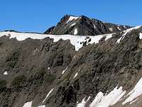
We then began to walk over the grassy valley floor toward the 12460 ft saddle. The east face of Tellurium Peak was well visible. I could see that there were 2 high points to the southeast of the main summit. It seemed like the ridge-top that I wanted to follow would take me up and down those high points.
At 9:20 a.m., after a 3.15 mile hike, we sat to rest for 15 minutes. Chris knew that I was very eager to reach the summit. He told me to go ahead and he would come behind me at his own pace. I gave him a walkie-talkie so that we could keep in touch.
![12460 ft Saddle]() 12460 ft Saddle
12460 ft Saddle![Steep grassy slopes]() Steep grassy slopes
Steep grassy slopes
Rather than going to the 12460 ft saddle, I decided to go up a steep grassy slope that seemed to allow me to reach the base of the southeastern ridgeline of Tellurium Peak. As I went higher, the slopes became steeper. At times, it felt like my backpack might tilt me backward causing me to tumble down the slope. At least it was all grass (with some deadly rocks here and there).
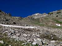
At 12400 ft, the slopes eased up. The grass was replaced by huge fields of small rocks. Hiking on the unstable rock could have been difficult but the snow banks that still covered some of the slopes made my hike much easier.
The nasty eastern slopes of Tellurium rose right above me.
![East Face of Tellurium]() Eastern slopes Eastern slopes | ![East Face of Tellurium]() Eastern slopes Eastern slopes |
![East Face of Tellurium]() Eastern slopes Eastern slopes |
At 12940 ft, I finally reached the base of the southeastern ridgeline of Tellurium. I could not see the summit itself but the first high point that I had seen earlier was right above me. It seemed like the way to the summit would be straight forward. The slopes around me had become yellow/reddish in color.
![Point 13110 ft]() First high point First high point | ![Point 13110 ft]() First high point First high point |
![Southern face of Tellurium Peak]() 20 ft down
20 ft down
I followed the ridge-top up until I reached the summit of the first high point. My progress suddenly came to the proverbial screeching halt. The south face of Tellurium Peak appeared in front of me. Its slopes were absolutely horrible: cliffs, scree and big drop-offs everywhere. To continue, I had to go 20 ft down a nearly vertical gully that was full of loose rock. If I were to slip, I would be sure to fall off the edge of the ridge-top. I stood there wondering what to do. Continuing up on those slopes all alone did not sound like a very smart thing to do. As much as I hated to do so, I admitted defeat and just sat there. It was 11:00 a.m. My GPS said 13110 ft elevation and a 4.25 mile hike.
![South Face of Tellurium]() South face of Tellurium
South face of Tellurium
I called Chris on the walkie-talkie. I guess I did not choose the right words when I talked to him. I meant to tell him that I did not want to walk back down the snow fields and the steep grassy slopes but I ended up telling him something along the lines that the route that I had taken had not been good and now I had reached a bad spot where I could not continue any more. I told him I would sit there for a few minutes to rest but would then walk back to him via a different route. He did not say anything at that time but later he told me that he had become concerned thinking that I was in trouble.
![Upper Tabor Creek Valley]() Upper Tabor Creek Valley
Upper Tabor Creek Valley
After a short rest, I quickly walked down the ridge-top to the base of it at the 12940 ft spot. Instead of going down the way I came up, I decided to go down to the 12460 ft saddle. I called Chris and told him that.
From where I was standing, I had great views of many of the local peaks including Anderson, Larson and Petroleum Peaks. Tellurium itself was in good view. I could see the two high points, including the one that I had climbed, sitting to the southeast of its summit.
![Larson Peak & Peak 13447 ft]() Larson Peak Larson Peak | ![Anderson Peak]() Anderson Peak Anderson Peak |
![Petroleum Peak]() Petroleum Peak Petroleum Peak |
![Tellurium & its 2 high points]() Tellurium and the 2 high points
Tellurium and the 2 high points
I then began to descend toward the 12460 ft saddle. As I went lower, the slopes became mostly rocky. I was afraid that after descending for a long time, I might run into a wall forcing me to go all the way back up to where I had come from again. The going was not easy but at least no major obstacles came my way. I did not reach the saddle itself but got to a grassy area below it. I was back on easy ground again.
I then began to walk fast down toward where I had separated from Chris. I saw him from far away. He was sitting with his back to me. I saw he turned around once and I thought he saw me so I did not call him on the walkie-talkie. He was startled by my approach when I was only 3 feet away from him. He suddenly jumped up and turned around thinking that he was being ambushed by a wild animal. I told him I did not mean to scare him. I thought he saw me coming. He said he was looking at the steep grassy slope expecting me to come down from there. He also said he wanted to call me but he was picturing me walking on a narrow ledge and he did not want me to lose my balance by the sudden ring of the walkie-talkie.
I then sat there to rest. The grassy slopes, the valley below us and the spectacular peaks around us were just gorgeous.
![Tabor Peak]() Tabor Peak Tabor Peak | ![Upper Tabor Creek Valley]() Tabor Creek Valley Tabor Creek Valley |
![Lake, Tabor Creek Valley]() Lake
Lake![Lake, Tabor Creek Valley]() Lake
Lake
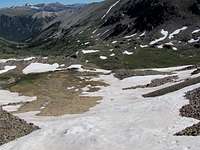
We then began to walk back. We did at times see the remnants of a faint trail. In the morning, we had been walking up on the west side of the valley. Now we were on the east side of it. As we went lower, we actually saw the lake that we had missed in the morning. There was actually more than one lake in the area. We went by the big lake (11820 ft) and sat there to enjoy the fantastic views. Chris was saying instead of toiling up the ugly scree slopes on the summits, we should come to a lake like this and set up camp. I though he had a valid point.
![Tellurium Peak & Lake]() Tellurium & Lake
Tellurium & Lake
The rest of the hike down the valley was very pleasant. Everything was so pretty. I could see the southern slopes of the 12791 ft Green Mountain that I hoped to climb a couple of days later.
| |
![Southern Slopes]() Green Mountain Green Mountain |
|
![Tellurium Peak & Tabor Creek Valley]() A look back at Tellurium (R) & Tabor Creek Valley
A look back at Tellurium (R) & Tabor Creek Valley
We were back at the trailhead by 2:50 p.m. My GPS showed an 8.71 mile roundtrip hike. Driving back on that nasty Lincoln Creek Road was a drag.


Comments
Post a Comment