
-
 19626 Hits
-
 90.07% Score
-
 31 Votes
|
|
Area/Range |
|---|---|
|
|
40.26180°N / 5.1814°W |
|
|
7680 ft / 2341 m |
|
|
Overview
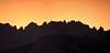
This is a climbing spot included in Sierra de Gredos, Macizo Central. With 40 granite peaks, it has aproximately 250 rock-climbing routes graded between III and 7b+ (max. 300 m). Some people say that there is no other area in Europe with so many peaks in less surface. The range offers one of the finest rock-climbing in Spain, it can be a perfect training area for bigger objetives. There is no many people outside weekends and holidays.Note: 2.341m is the elevation of La Mira, the highest mountain in Los Galayos. In some sources La Mira and its neighbours are not included in Los Galayos, then the highest peak would be Gran Galayo (2.216 m / 7,270 ft). The coordinates up are those of La Mira.
 |  |  |  |  |
Getting There
Los Galayos base could be Plataforma del Nogal del Barranco, wich is parking with tables and a drinking fountain.PRIVATE VEHICLE
From Madrid (175 Km)
Take A-5 to Talavera de la Reina and then the C-502 to Avila, after Ramacastañas turn right on C-501 to Arenas de San Pedro (the biggest town in the region), finally drive 11 Km to Plataforma del Nogal del Barranco after the nice village of Guisando.
From Avila
C-502 passing Puerto de Menga, Puerto del Pico, Cuevas del Valle and Mobeltrán you'll arrive to Ramacastañas. Then as I said.
Get informed of winter road conditions in pages 601 and 611 of "Teletexto" TVE.
BUS
Madrid-Arenas de San Pedro or Avila-Arenas de San Pedro, then take a taxi, hitch-hike (better on weekends) or walk (2 h 30 min).
 |
Red Tape
No one yet. |  |  |  | 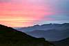 |
When To Climb
The weather is almost perfect, but be careful because the area is over 2.000 m. When it rains the rock slips a lot due to the green lichens. The best season for rock-climbing is from May to October.INM weather forecast for Sierra de Gredos.
 |  |  |  |  |
Camping
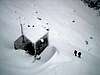
Guisando campingsRefugio Antonio Victory (1.950 m)
In front of Torreón de los Galayos. Guarded, 16 places, water, bar and radio. Take your sleeping bag with you. Opens all the year but in Winter only on weekends.
There is no covered bivouacs and a tent can be difficultly pitched, there is no comfortable places.
El refugio Victory incomunicado.
 |  |  |  |  |
Foremost peaks
Aguja NegraAguja Paco Pérez
Cabeza del Covacho
El Capuchino
El Cervunal
El Monaguillo
El Mono
El Pollo
El Pollo Negro
El Risquín
El Tridente
Espaldar de los Galayos
Falso Galayo
Gran Galayo
La Mira
La Vela
Las Berroqueras (Norte, Central y Sur)
Peña del Aguila
Peña del Chocarrón
Peña Gallina
Pequeño Galayo
Punta Acuña
Punta Arenas
Punta Conchita
Punta de los Lirios
Punta del Jardín de la Pilar
Punta del Pilar
Punta Desconocida
Punta Díaz-Rubio
Punta Don Servando
Punta Fina
Punta Innominada
Punta Maliciosa
Punta Margarita
Punta María Luisa
Punta Mónica
Punta Olvidada
Punta Peñalara
Punta Tonino Re
Puntas Gemelas
Risco Angel
Risco de las Palomas
Risco del Jardín del Puente
Risco del Puente
Risco Enebro
Risco Jugaero
Risco Moreno
Risco de la Trocha Palomo
Torre Amezúa
Torre de la Seta
Torre de Pachi
Torre del Conejo
Torre del Conglo (o Congio)
Torre Gregoria
Torre Marian
Torre Rosblanc
Torreón de los Galayos
 |  |  |  |  |
Foremost approaches to the peaks
Canal (gully) de la Aguja NegraCanal de las Berroqueras
Canal del Capuchino
Canal del Gran Galayo or Canal de Trocha Palomo
Canal del Torreón
Canalón Oeste del Risco del Puente
Espaldar de los Galayos
Jardín de la Punta del Pilar
Jardín del Risco del Puente
 |  |  |
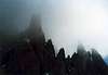
Torreón de los Galayos
This impressive granite peak (about 2.100 m) is the most atractive Galayos' pinnacle. It is vertical on all sides and rises 50 m over zócalo (rock base) plus 100 m from zócalo to La Apretura. Its outline form a part of the Spanish Mountaineering Federation official emblem.Simplifying Torreón is formed by 2 sides:
-N and W faces
-S and E faces
The historical name of the peak was El Pilón or La Torre. They named Torreón after the S face first ascent.
First Climb
N summit (Cara-Chimenea Oeste, Normal): Teógenes Díaz and Ricardo Rubio on May 16th 1933. Primera ascensión al Torreón: 75 años después.
S summit (Cara SE, Sur Directa): Florencio Fuertes, José González Folliot and Antonio Rojas on July 19th 1947.
First winter ascent: Antonio Moreno and Ramón Somoza on January 1st 1948.
Curiosities
Theoretic weight : 750 million Kg / 1,650 million Pounds.
Esteban Vicente solo-climbed all the existing routes (9) in 12 hours.
In some storm days it's posible to hear the " bees buzzing" on the summit.
The summit is 90 cm / 36 in wide.
 |  |  |  |  |
External Links
- Grupo Gredos de montaña
Interesting web to practice activities in Sierra de Gredos, rock climbing, routes and diferents expeditions
- Sierra de Gredos
Restaurants, Hotels, campings....and routes, rock climbing, activities and zones in the sierra de Gredos
- Rock Climbing in Galayos
To rock climbers
- Ayuntamiento de Arenas
Mountaneering section in this Arenas de San Pedro's council web. Includes a Galayos' map and information a little weak. In Spanish.
- Guía Tietar
This web wants to be the reference in all about Los Galayos. It's very complete: good images and a lot of information. In Spanish.
- Escuelas de Escalada
This web submitted by Desnivel, a Spanish publishing company of mountain books, includes Galayos' rock climbing information. In English.
- Junta de Castilla y León
Hotels, Campings and interesting telephones of Gredos
- Desnivel Magazine #203 Climbing Info
Complete climbing info of Peña del Aguila & Berroqueras. Very interesting. Only in Spanish.
- Mountain and Climbing Guiding/Instruction
Rock and Ice climbing school. Mountain Guiding. English speaked.
OBIJUANKENOBI71 - Jun 14, 2002 12:10 am - Voted 10/10
Untitled CommentRESCUE: Grupo de montaña de la Guardia Civil de Arenas de San Pedro. (920) 37 00 31
BUS: Madrid-Arenas de San Pedro. Empresa Doaldi (salida Estación Sur de Autobuses) Informacion: (91) 468 45 11
NATIONAL METEOROLOGICAL INFORMATION: 906 365 365
MAPS AND GUIDES: Libreria Desnivel. C/Amor de Dios 11. Madrid. (91) 369 37 40 14
BAR EL GALAYAR (Macario): Libro de Piadas. (920) 37 40 14 (Guisando)
CAMPING LOS GALAYOS: (920) 37 09 21. Ctra. Linarejo, s/n. Guisando (Avila)
GRUPO DE MONTAÑA ARENAS. Plaza Federico Fernandez, 5. Arenas de San Pedro (Avila).
OBIJUANKENOBI71 - Jun 14, 2002 12:14 am - Voted 10/10
Untitled CommentAll the itineraries described during 3 stations a year bring near us to the walls to begin with anyone of the multiple possible escalades. However in winter they acquire own personality changing the rock for abundant snow, it doesn't exempt of certain difficulty.
Due to their orientation it is advisable to get up early, as well as the use of the helmet since is frequent the falls so much of stones as of pieces of ice.
Next simply we mention them, indicating their difficulty under these conditions:
Canal de Las Berroqueras, 300 m, AD, it A
Jardin de la Punta del Pilar, 250 m, Dsup, it B
Jardin del Risco del Puente, 200 m, Dsup, it C
Canal del Capuchino, 250 m, D, it D
Canalon Oeste del risco del Puente, 250 m, Dsup, it E (Recomendable)
Canal de la Aguja Negra, 300 m, AD a D, it F (recomendable)
Canal del Torreón (hasta la Pta Don Servando), 250 m, AD a D, it G
Canal del Gran Galayo, 200 m, PD, it H
Other escalades in snow or ice:
Punta Don Servando, canal NO, via Tutti-Frutti, 150 m, MD, (recomendable)
Punta Don Servando, canal SE, via del Cursillo, 80 m, ADsup.
Canal NO de la brecha Gran Galayo-Aguja Paco Perez, 100 m, D.
Canal Norte del Gran Galayo, 250 m, Dsup.
(Todos los itinerarios descritos durante 3 estaciones al año nos acercan a las paredes para empreder cualquiera de las multiples escaladas posibles. Sin embargo en invierno adquieren personalidad propia cambiando la roca por abundante nieve, no exenta de cierta dificultad.
Debido a su orientacion es recomendable madrugar, asi como el uso del casco ya que son frecuentes las caidas tanto de piedras como de trozos de hielo.
A continuacion simplemente los mencionamos, indicando su dificultad en estas condiciones.....)
Diego Sahagún - Jun 29, 2002 9:31 am - Voted 10/10
Untitled CommentAntonio Victory Rojas (1890-1972) was the first climber on Gran Galayo, El Pájaro (La Pedriza) and Ameal de Pablo (Gredos). Thus between 1914 and 1916. On October 1914 he is member of Peñalara society and president between 1921 and 1952. He was the promoter of La Pedriza, Peñalara and Pinar de la Acebeda protection areas. Also he was the builder of fuente (drinking fountain) de los Geólogos (Sierra de Guadarrama) and some Spanish mountain refuges as Refugio Antonio Victory (1949). There is a trail at Sierra de Guadarrama called Senda (trail) Victory.
OBIJUANKENOBI71 - Jul 1, 2002 11:42 pm - Voted 10/10
Untitled CommentThe best place where to spend the night after an intense escalade day is the Refugio Victory. It is located 1950 meters high, I joust in front of the Torreón. This almost kept the whole year (every day of summer and weekends in winter). it Has 16 squares (although stretches out in an incredible way if a good storm is mounted or it whips the snowfall). ThisHas water and tavern service. It has first-aid kit and radio for accidents and emergencies.
All this owes it to their current refugieros: Carlos Arroyo (Coli) and José María Alonso (Majara) since they are the main authors of their reconstruction and their maintenance, from 1986 up to now.
CONTACT: Carlos Arroyo (91) 739 96 58
ACCESS: To arrive to him we take the marked road that leaves from the parking of the Walnut of the Ravine, something to the right of the source. During the road we will see other two more sources, in those that we can stuff our canteens before it finishes it and harder ascent. This final tract of the road is more beautiful and surer for the " zetas " (crossing the river to the left) that for the channel of the Apretura. We will take approximately 2 hours in saving these 750 meters of difference.
(El mejor sitio donde pasar la noche tras una intensa jornada de escalada es el Refugio Victory. Está situado a 1950 metros de altura, justo enfrente del Torreón. Esta guardado casi todo el año (todos los dias de verano y fines de semana en invierno). Cuenta con 16 plazas (aunque se estira de forma increible si se monta una buena tormenta o azota la nevada). Tiene agua y servicio de cantina. Cuenta con botiquin y radio para accidentes y emergencias.
Todo esto se lo debemos a sus actuales refugieros: Carlos Arroyo "Coli" y José María Alonso, "Majara" ya que ellos son los principales artífices de su reconstrucción y su mantenimiento, desde 1986 hasta ahora.
CONTACTO: Carlos Arroyo (91) 739 96 58
ACCESO: Para llegar a él tomamos el marcado camino que sale desde el aparcamiento del Nogal del Barranco, algo a la derecha de la fuente. Durante el camino veremos otras dos fuentes más, en las que podemos rellenar nuestras cantimploras antes de la ultima y más dura subida. Este tramo final del camino es más bonito y seguro por las "zetas" (cruzando el rio a la izquierda) que por la canal de la Apretura. Tardaremos aproximadamente 2 horas en salvar estos 750 metros de desnivel. )
OBIJUANKENOBI71 - Oct 8, 2002 10:13 am - Voted 10/10
Untitled Comment"Los Galayos" (Cat. 2)
Km.7 of the road to Arenas de San Pedro
05417 - Guisando
Tel: 920374021
Open: from 1/1 up to 31/12
Located in the near town of Guisando, at 4Km of the Nogal del Barranco, point where we begin our ascension to Galayos, their characteristics are:
.- Parceled camping site
.- It accepts caravans, Locations: 30
.- Showers of hot water: 4
.- Washbasins of cold water: 4
.- Washbasins of hot water: 2
.- Laundry of cold water: 12
.- Sink of cold water: 12
.- Mature night: 2,10 european €
.- Boy night: 1,65 european €
.- Car night: 2,10 european €
.- Motorcycles night: 1,65 european €
.- Caravan night: 2,70 european €
.- Spread night: 2,70 european €
.- Autocaravan night: 2,70 european €
.- Electricity night: 1,95 european €
Diego Sahagún - Jan 18, 2008 8:47 pm - Voted 10/10
Robo en el Victoryhttp://www.desnivel.com/object.php?o=16533
Diego Sahagún - Sep 9, 2008 7:02 am - Voted 10/10
Desequipamiento en Galayos: "Talibanes de la roca"http://www.desnivel.com/newsletter/desnivelaldia/object.php?o=17516
Diego Sahagún - Mar 10, 2009 8:25 am - Voted 10/10
Galayos: propuesta de normas de equipamiento y escaladahttp://www.desnivel.com/deportes/escalada_en_roca/object.php?o=18222