
|
|
Mountain/Rock |
|---|---|
|
|
47.36610°N / 14.54860°E |
|
|
Hiking, Trad Climbing, Skiing |
|
|
Spring, Summer, Fall |
|
|
7828 ft / 2386 m |
|
|
Overview
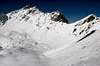
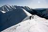
Geographical Classification: Eastern Alps - Niedere Tauern - Triebener TauernGamskogel differs slightly from its grassy neighbours, as it has quite an impressive rocky appearance from north. It offers the most spectacular ridge climb in Niedere Tauern (3 UIAA). It comes as a surprise that Gamskogel is a popular ski tour, either from north, using one of the north-western couloirs, from south-east or as a round (see later). Sometimes, only the western side-peak, Hochleitenspitze, is climbed. The ridge between them is at most 1 UIAA and takes some 10 minutes to climb in either direction.
Located in the main ridge of Niedere Tauern, Gamskogel thrones over nice cirques, Mödringkessel, Hühnersteige, Bärentritt and Ochsenboden. Three ridges meet here each other: the northern one with Geierkogel, the Seckauer ridge in the east and the Glaneck ridge in the south. The main valleys are Triebental (north), Gaalgraben (south) and Bärntal in the west.
You might also enjoy the other popular summits in this area (Triebental), e.g. Großer Griesstein and Kerschkern with their siblings. Plenty to fill up a longer week-end, using one of the accomodation possibilities.
 |  |  |  |
Getting There
From north through the Triebental, exit the A9 highway in Trieben and head to Hohentauern, leaving left to Triebental at Gasthof Brodjäger. Drive to the end of the road.For the southern approach over Bärntal, continue to Hohentauern and turn to left (east) at Gasthof Bruckenhauser 8km after this town.
From south through the Gaalgraben, leave the S36 in Knittelfeld, drive to Gaal, until the end of the road.
Routes overview
- From north:
- From Bergerhube in Triebental, over Mödringalm to the north-west couloir. Marked, easy. 3h
- The Gamskögel ridge. From Mödringalm to the couloir west of Mödringkogel, up to the saddle and partly south of the ridge to the top. Not marked, 3+ UIAA. 4-5h.
- The round (with ski). From Bergerhube over Mödringalm, traversing "the Paradise" - north-east slopes of Mödringkogel - to Krugtörl and Krugkoppe 2042m west of it. Ski down to Hühnersteige to approx. 1800m. Traverse to Bärentritt and ascend the broad south flank. Not marked, easy. 4-5h
- From Bergerhube in Triebental, over Mödringalm to the north-west couloir. Marked, easy. 3h
- From south (quite lonesome):
- From Lamer in Gaalgraben on a forest road, leaving the marks at 1600m go to west and on footsteps to Gaaler Törl and over Hochleitenspitze (in summer) or directly up the south flank. Easy. 3.5h
- From west through Bärntal to Bärntalalm, then head south-east to Gaaler Törl, then on the south ridge of Hochleitenspitze (ski depot) and over the ridge to Gamskogel. Marked, 1 UIAA on the ridge to Gamskogel (can be avoided through the south flank). 3.5-4.5h
- From Lamer in Gaalgraben on a forest road, leaving the marks at 1600m go to west and on footsteps to Gaaler Törl and over Hochleitenspitze (in summer) or directly up the south flank. Easy. 3.5h
 |  |  |  |
Red Tape
No official limitations, no parking fees on the parking places.When to climb
The ridge is best done in summer, it dries quickly after rain. The couloirs and the south flank need stable snow conditions, as well as the round tour. The downhill from Krugkoppe is up to 45° steep, avoid it, if the conditions are less than perfectly stable.Mountain Conditions
- For avalanche conditions, see Lawinenwarndienst Steiermark.
- wetter.orf.at and
- ZAMG contain weather forecasts.
 |  |  |  |
Accomodation
- Triebentalhütte of Alpenverein, self-catering
- www.hohentauern.at contains an online list of accomodation for this area. Note, that Bergerhube in Triebental has a climber's "lager".
- Gaal and Seckau have a good overview of hotels and private rooms online (for southern approach).
- Camping sites in Steiermark
Literature & Maps
Guides- Kurt Schall: Schitourenatlas Österreich Ost, 2005. A selection of popular ski tours.
- Gernot & Gisbert Rabeder: Skiführer Triebener Tauern, 1988. A complete ski touring guide to Triebener and Seckauer Tauern. Out of print, but the only complete source.
Maps
- ÖK 130 Trieben 1:50000
- F&B WK 212 Seetaler Alpen - Seckauer Tauern 1:50000
- Online map at www.austrianmap.at