
-
 3345 Hits
-
 80.49% Score
-
 12 Votes
|
|
Mountain/Rock |
|---|---|
|
|
47.26551°N / 13.58065°E |
|
|
Hiking, Skiing |
|
|
Spring, Summer, Fall, Winter |
|
|
7346 ft / 2239 m |
|
|
Overview
Hundskogel is one of many less important summits above the Obertauern plateau. Also below its summit cable cars reach. If we use them, the ascent can be really a short one. Otherwise from Seekarhaus we also don't need more than one good hour to reach the top. Because it is rising in the main ridge of Niedere Tauern, also Hundskogel is offering quite a nice panorama on all sides. Some more meters of altitude would benefit the view though.
 Seekarspitze |
 Sonntagskarhoehe and Dachstein |
 Towards Hochgolling |
 Gamskarlspitze |
The ascent directly from the upper station of Seekarhaus cable car is short, but a steep one. That ridge is less appropriate for skiing, but still possible. The southeast slope however is less steep and grassy in summer and autumn. In winter and spring it is appropriate also for a bit less experienced tour skiers. Also the recommended summer route does not go directly from the cable car station on top, but detours it by the northern side and then goes up by the south-eastern slope (not marked).
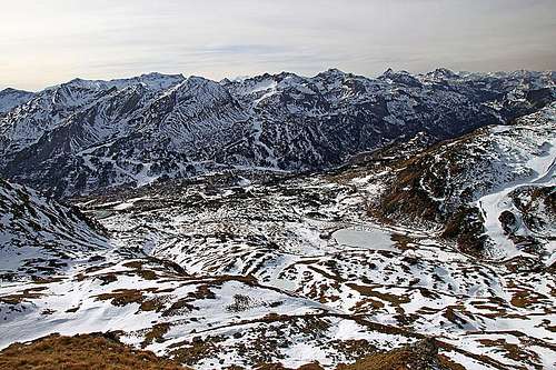 Obertauern plateau from Hundskogel
Getting There
Even if it is also possible to reach the summit of Hundskogel from the trailheads on the north and east, by far most popular trailheads are on the Obertauern plateau. The Pass, 1738 m, lies south-southwest of Hundskogel and is crossed by the main road, connecting Lungau and the valley of Enns. From the Obertauern Pass we can even drive a bit further up. Until all parking places are not occupied, we can drive from the pass to Seekarhaus, 1797 m. Otherwise in winter ski bus is continuously driving till there (free of charge). From the main road you have some 2 km to Seekarhaus. The trailhead can of course be even much higher, even on 2100 m, provided that you buy a ski ticket.
Summit Ascent

The NW ridge of Hundskogel
From Seekarhaus we go by a marked path towards the north-east, at first towards the distinct, important pass of Seekarscharte, 2022 m. Over this pass the marked path continues into the next valley and further across the saddle towards the north-east to Giglachsee. But even before reaching Seekarscharte we turn right, going by the ski track towards the east, all the way to the upper station of the right cable car. When operating, it's also a restaurant there. From there the summit of Hundskogel and the route on it are clearly seen. We go directly by the ridge, on some places we can even follow a tiny path. The last meters are more steep and require a safe step. If you find this ascent route too steep and demanding, you can go by the marked path left around the hill (by the northern side), or right (by the southern side), until you reach below the south-eastern slope. That one is much less steep and the ascent over it is fairly easy. By the Swiss Hiking Scale the difficulty of the north-west ridge would be T3, and of the south-western slope T2.
Mountain Huts

Seekarhaus
> Seekarhaus, 1797 m. Reachable by car (bus).
> Oberhuette, 1869 m. By the lake of the same name, north-east of the summit.
When To Ascend?
On Hundskogel we can ascend any time of a season. In winter conditions the ascent over the north-west ridge can be more demanding and requires a proper equipment (ice pick and crampons). For skiing, Hundskogel offers a nice south-eastern slope, and then the ski descent goes further down by the regular ski slopes.