
-
 5932 Hits
-
 82.48% Score
-
 15 Votes
|
|
Mountain/Rock |
|---|---|
|
|
47.24713°N / 14.15138°E |
|
|
Hiking, Mountaineering, Skiing |
|
|
Spring, Summer, Fall, Winter |
|
|
8117 ft / 2474 m |
|
|
Overview
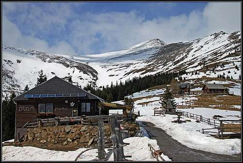
Greim from Greimhuette
dedo - Greim from the north
What Preber is in the respect of tour skiing for Schladminger Tauern, that is Greim for Woelzer (Rotenmannen) Tauern. Very nice, easy and so very popular. One of the Eastern Alps great summits for tour skiing! That perhaps holds true more from the perspective of southerners - both summits rise just above Mur valley, but the northern ski tours have a bit different character.
The distinguishing feature of Greim is its southern ravine - Greimrinne in which the Woelzer Bach has its source. It cuts the whole southern slope, a bit V-shaped and not very deep, but enough that in spring snow stays there far after the surrounding slopes are already quite barren. That's why despite the southern orientation and not so high altitude, Greim is so perfect for skiing.
In summer, Greim is just a typical Niedere Tauern summit. Mostly grassy, on higher altitudes also rocky, but not much sharp and with no big walls. Very fine for hikers, but not interesting at all for climbers. By its ridges well marked paths go, connecting its summit with trailheads above the Mur valley and with other summits of the main chain.
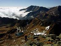
The view from Greim is very broad, at least on the southern side and along the main chain in the E-W direction. The neighbouring summits are lower and only on the north one can see a few higher ones. The sea of mointains is waving all around.
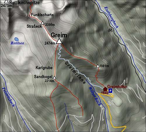
The big Greimrinne is bordered by two distinct ridges. From the summit one ridge goes in a S-SW direction and then on Sandkogel, 2214 m, branches. The S branch ends on Zirbeneck, 1628 m, the SE branch on Schoeneben, 1705 m. The second ridge goes from the summit of Greim in the SE direction, reaching the point 1981 m and then lowering considerably on the broader area around Greimhuette (hut). This SE ridge has on the other side of the summit its continuation towards the NW. It soon reaches the unimportant summit of Strasseck, 2390 m, and then lowers on Funklscharte (around 2250 m), where the narrow area of Greim ends and Rettlkirchspitze, 2475 m, begins. The steepest side of Greim is its NE face, the least steep is the S ravine, while the W slope is a bit steeper, just enough that up there no useful path ascends.
 Click to run this one online Click to run this one online |
Getting There

Rettlkirchspitze from Greim

Greim Summit

Summit wind shot
See the main page of Niedere Tauern to find information how to get into the valley of Mur. From the west, you come there from St. Michael (exit from Salzburg-Villach highway), from the east you drive from Leoben (exit from Pyhrn highway). Mur valley can also be reached from the south over several passes, crossing Gurktal Alps. From the north you best reach the starting point for Greim tour over Soelk Pass in Niedere Tauern.
Once being in Mur valley, you deter into the side valley, reaching by one of two roads St. Peter am Kammersberg. From there drive by the road (towards N-NE), which connects it with Oberwoelz. The other option is to deter from Mur valley in Niederwoelz, drive towards the NW to the town of Oberwoelz and then further on towards the west. From the road Oberwoelz - St. Peter you deter north on the mountain road in Pollau am Greim. The inscription is clear, saying: "Greim, 7 km" and other inscriptions direct you also towards the Greimhuette (hut), 1649 m. The road is usually well maintained, only in winter it is steep enough to require in worst occasions winter equipment for driving. Due to popularity of Greim ski tour the road is soon cleaned and in the hut you can get food and beverage.
The other trailhead for summer ascents (from the north) is Neunkirchner Huette, 1535 m, at the end of Eselsbergbach valley. The road into the valley is however not opened for public traffic (2 h walk to the hut).
Routes Overview
Summer marked paths
1. From Greimhuette, 1649 m, you go NW towards Greimrinne, but on the altitude of some 1770 m the marked path turns up (towards the N) and ascends the point 1981 m on the SE ridge of Greim. Then by the ridge on top. Marked, 2 h 15 min from the hut.
2. Also the paths by both ridges which descend from Sandkogel are marked. I have no information till where you can drive up by car, but marked paths ascend up all the way from Poellau and Feistritzbach. In Arlingbach they join but then you must choose cart roads to go by either of the two ridges. Altogether this variant has the biggest altitude difference.
3. From Neunkirchner Huette, 1535 m, you continue a bit towards the west (towards the valley end), but on 1674 m deter south and start ascending on Funklboden. From there continue to Funklscharte and by the main ridge over the summit of Strasseck on top. Marked, 3 h 30 min from the hut.

Crossing into Greimrinne

On Greim ski tour

Skiing from Greim
Ski tour
You start at Greimhuette, 1649 m. The ski track goes first by the marked path towards the NW, but later continues in the same direction, crossing the slopes and finally on some 1850 m reaching the bottom of Greimrinne, the big S channel. Crossing of the slopes before the channel is easy, only when snow is very hard there is some danger of sliding. When in the big ravine, the ski ascent track goes in slight turns or even directly up, because the ravine is just appropriately steep. The direction is towards the NW, above you see the SW ridge, the summit cross is on the right. Actually, you can also choose freely the ascent route, choosing best snow conditions. The upper slope (below the SW ridge) is a bit more steep, but you can ascend without any additional equipment (ski crampons), unless in really hard snow. Keeping slightly right - below the SW ridge or by it - you continue on top. 2 h 30 min for a ski ascent.
In occasions where the Greimrinne is still filled with snow, but the neighbouring ridges are more barren, Greim is a great goal also for boarders. They can comfortably walk up by a grassy and rocky terrain and then do a boarding descent by Greimrinne.
In the upper part you ski down by the ascent route. Below, however, you can continue skiing down by Greimrinne. It is nice and only when it narrows completely, you exit it left, catching a cart road which comes there from the hut. Then just follow the cart road in a slight descent - you will reach with skis the interior of your car trunk, if you wish.
You can see a detailed map on: http://www.austrianmap.at/.
That's in German, but as of classical maps, you can refer to:
Alpenvereinskarte Bl. 45/3. Freytag & Berndt u. Artaria KG Publishing and Distribution Bl. WK 203 Kompass K 222.
Red Tape
No Limitations.
Mountain Huts
- Greimhuette, 1649 m. Stands on a broad terrace of Greim's SE ridge. It is a private hut, opened most of a season. Tel.: 0800 / 801 803 - 0096 (free info hot line). Sleeping is not possible in the hut.
- Neunkirchner Huette, 1535 m. Stands at the end of Eselsbergbach valley. It is a self-service type hut, reachable from Eselsberg or Hinter Poellau in 2 hours of walk. It has 10+13 beds and two winter rooms. Phone numbers: Hut: +43/2635/61188, in valley: +43/2635/65017, hut master: +43/2635/65017. The hut is a nice destination also for biking.
When to Ascend?

Greim in September
Greim can be ascended any time of a season. That holds true for the southern ascent, provided that in winter when there's a lot of snow, you have equipment for tour skiing. Only in harders winter conditions the ascent would require crampons and ice pick, otherwise poles and eventually ski crampons are enough. The northern ascent is long and very rarely done in winter (not a ski tour).
Your Help Needed
You are welcome to add more information, especially:
- Summer routes descriptions (especially the northern ascent).
- Other outdoor activities on Greim.
- Panorama pictures.
- Other interesting features in the neighbourhood.