
|
|
Mountain/Rock |
|---|---|
|
|
47.36360°N / 14.68190°E |
|
|
7926 ft / 2416 m |
|
|
Overview
Geographical Classification: Eastern Alps - Niedere Tauern - Seckauer Tauern
Hochreichart is the second highest peak in the Seckauer Tauern group, which in turn is located in the east part of the Niedere Tauern range. Having long grassy slopes with only some rocks here and there, it is an easy destination in summer and a nice ski tour in winter and spring. Especially with skis there are many possibilities of different steepness. On the other hand, the Hirschkarlgrat offers some scrambling. You can as well "take" some surrounding peaks on the same day. Hochreichart is not the only worthy mountain in Seckauer Tauern, there are also Seckauer Zinken, Pletzen, Geierhaupt, Kerschkern, Gamskogel and more. You will probably not be alone here, but the area is not crowded either.
 |  |  |
Getting There
Coming from south, take the S36 highway, exit at Knittelfeld. Before Gaal, in Ingering, turn to the North into Ingeringgraben, until the end of the road at Ingeringsee (summer) or Wh. Ingering (winter).For the northern approach, take the A9 highway, exiting at Kalwang or Mautern in Steiermark. See the routes for possible destination towns.
Routes overview
You can choose from an easy walk to some conditionally or technically demanding route, or even join any two of them to a nice round or cross, possible to do in a day, or stay over night in the Hochreichart hut (see later).- From Ingeringgraben (south approaches), approx. 1200 hm:
- Through Brandstättergraben, Brandstättertörl and the south-east ridge. With skis directly at the brook, except in the late spring - with less snow in the lower part, the summer ascent is better. Marked, easy. 3-4h.
- Schmähhausrücken (South ridge): is followed directly, on footsteps, not marked, easy. 3-4h
- Hirschkarlgrat (West and North-west ridge) and Hölltal: From Ingeringsee into Hölltal and to Hölltalsattel (footsteps), from here on the ridge. Not marked, climbing I-II. 4-5h.
- The ridge over to Geierhaupt is easy, after overcoming Hirschkarlgrat. Partially marked, 2-3h.
The ski descent is some 35° steep, the gullies even more. Brandstätter Kogel offers a wonderful option, the western gully (30°).
- Through Brandstättergraben, Brandstättertörl and the south-east ridge. With skis directly at the brook, except in the late spring - with less snow in the lower part, the summer ascent is better. Marked, easy. 3-4h.
- From north, all marked and easy, but much longer, approx. 1600 hm and more:
- From Unterwald (at Schoberpass) through Ripplgraben, Schönebentörl and north-ridge.
- From Pisching through Pischinggraben, over Feistererhorn, and Kleinreichart to the north-ridge. Very long, some 1900 hm.
- From Kalwang - Obere Liesingau through Hagenbachtal, Hochreichart-Schutzhaus (see later), Brandstätterkar, Brandstättertörl and south-east ridge. Also with skis. 5h
- 3 - downhill variant (only by stable snow conditions): From the top to north-west down to a saddle, then north to Schönebentörl over a steep narrow slope. Less steep to east to Hochreichart-Schutzhaus.
All the northern routes are very lonesome and, despite of being marked, sometimes harder to find. - From Unterwald (at Schoberpass) through Ripplgraben, Schönebentörl and north-ridge.
 |  |
Red Tape
No official limitations. Besides the marked paths, you are free to choose any way you like. Ingeringgraben is a hunting ground, so wild camping in the woods is probably not a good idea. There are no parking fees in Ingeringgraben and no toll roads. But the roads are not cleaned from snow.When To Climb
All year. The eastern slopes are quite steep, so beware of avalanche danger (a situation analysis and forecast is at Lawine Steiermark). The orientation on those many ridges can be quite complicated in the fog.Summit panorama
PletzenHochalmspitzePreberHochgollingHochwildstelleGamskogelDachsteinGeierhauptGr. BösensteinHochhaideTotes Gebirge
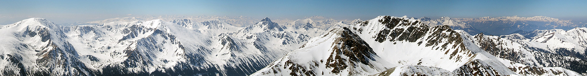 |
The summit panorama from Pletzen over Geierhaupt to Totes Gebirge. Quite a lot can be seen from Hochreichart: Seetaler Alpen in the south, Hochalmspitze, Schladminger, Wölzer, Rottenmanner Tauern in the west, Dachstein and Totes Gebirge in the north-west, Eisenerzer and Ennstaler Alpen in the north and east.
Accomodation
There are no alpine huts of Alpenverein in Seckauer Tauern, but most ascends can be done in one day. The Ingering area is reachable in 2h from Vienna and in half that time from Graz, so you can save yourself much time staying in some of the towns overnight, and it doesn't cost much. There are far too many alpinistic opportunities to stay just one day.- Hochreichart Schutzhaus (a Touristenklub hut), open in May-October on week-ends
- Camping sites in Steiermark
- Seckau and Gaal have a good overview of hotels and private rooms online.
Mountain Conditions
For avalanche conditions and ski trip reports, see Lawine Steiermark in winter. Weather forecasts are at wetter.orf.at and ZAMG.Guides & Maps
Guides- Kurt Schall: Schitourenatlas Österreich Ost, 2005. A selection of popular ski tours.
- Gernot & Gisbert Rabeder: Skiführer Triebener Tauern, 1988. A complete ski touring guide to Triebener and Seckauer Tauern. Out of print, but the only complete source.
Maps
- ÖK 131 Kalwang 1:50000
- F&B WK 212 Seetaler Alpen - Seckauer Tauern 1:50000
- Online map at www.austrianmap.at