
-
 4106 Hits
-
 79.78% Score
-
 11 Votes
|
|
Mountain/Rock |
|---|---|
|
|
47.27259°N / 13.54408°E |
|
|
Hiking, Scrambling, Via Ferrata, Skiing |
|
|
Spring, Summer, Fall, Winter |
|
|
7710 ft / 2350 m |
|
|
Intro
As this is one of those rare summits, where we despite not such a hard access have not reached the highest point, I am just drafting this page, and am more than happy to give it to anyone who would have more first hand experience with Seekarspitze. On the other hand, it's a nice and popular mountain, so why not giving it a start page.Overview
Seekarspitze from the east, from Hundskogel

On the east ridge
Steinkarspitze is a summit in the main ridge of Schladming Tauern, which is running there in the west-east direction. As from the summit another short, rocky south ridge descends, the mountain really looks like a sharp peak (Spitze). From the fore-summit in the east ridge towards the north another long ridge deters, culminating first on on Steinkarlspitze, then continuing further towards the valley of Enns.
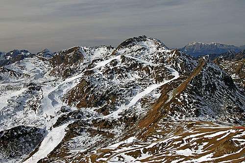
As we can see on the embedded photos, all southern slopes of Steinkarspitze are arranged into regular ski terrains. Cable cars bring skiers as high as on 2200 meters of altitude. In summer it is also possible to do a round tour by marked paths, crossing the summit. As said, a ski (or snowboard) descent is somehow more difficult, but due to nearness of cable cars very popular. The ascent over the upper part of the summit ridge is a bit exposed.
The Views
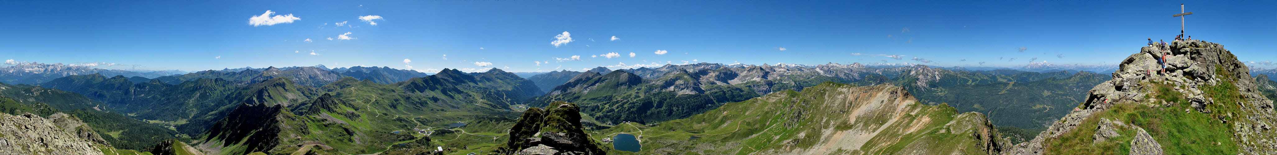 Click to run this one online |
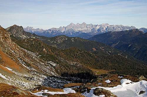
The view on Dachstein
Getting There
Even if it is also possible to reach the summit of Steinkarspitze from the trailheads on the north, by far most popular trailheads are on the Obertauern plateau. The Pass, 1738 m, lies south of Seekarspitze, and is crossed by the main road, connecting Lungau and the valley of Enns. From the Obertauern Pass we can even drive a bit further. Until all parking places are not occupied, we can drive from the pass to Seekarhaus, 1797 m. Otherwise in winter ski bus is continuously driving till there (free of charge). From the main road you have some 2 km to Seekarhaus. The trailhead can of course be even much higher, even on 2200 m, provided that you buy a ski ticket.Summit Ascents

Starting the tour by Seekarhaus

The summit slope (SE)
1. East Ridge.
This is the most popular ascent route on Seekarspitze. From Seekarhaus we go towards the north-west to a small chapel, and then right along the ski slope (looking upward). We aim a distinct saddle on the east ridge. The summer path crosses the ski track soon, ascends a bit more steep slope and higher reaches the ski track again. In winter it is much better if we simply ascend along the edge of the ski piste (using tour skis). A bit below the highest point of ski tracks the marked path brings us on the edge of a small basin below the south-eastern summit slope of Seekarspitze. The path turns up towards the east ridge, but before reaching it, continues some more time across the slope. Then it climbs the summit ridge and goes by it on top. The last part is a bit exposed and may in winter conditions require appropriate equipment (ice pick and crampons). We were on the east ridge on November 17th, and in light summer shoes and without crampons and ice pick we did not dare to ascend over the icy slope and the ridge. From the hut the ascent requires good 1 h 30 min.2. West Approach.
From Seekarhaus another marked path goes also towards the west, to Gruenwaldsee. This lake can be reached by marked paths also directly from the Obertauern Pass, going northwards. From the lake the marked path continues further towards the north on Seekarschneid (ridge), 2288 m, and there turns towards the east. We climb Seekarspitze over the summit rocks by a marked, partially protected path. This route, combined with #1, can make a nice round tour which would require only half of a day.Mountain Huts

Seekarhaus
> Many hotels and huts on Obertauern Pass.