
-
 4731 Hits
-
 82.48% Score
-
 15 Votes
|
|
Area/Range |
|---|---|
|
|
43.59855°N / 110.35686°W |
|
|
Hiking, Scrambling |
|
|
Spring, Summer, Fall |
|
|
8410 ft / 2563 m |
|
|
Overview
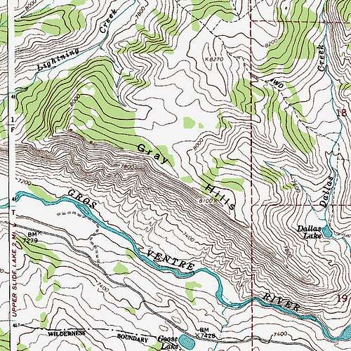
East of the Red Hills, the Mount Leidy Highlands open up into a wide valley to accommodate the drainage of Slate Creek, and from there, the Gray Hills run for almost five miles all the way to Upper Slide Lake.
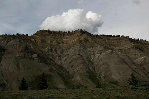
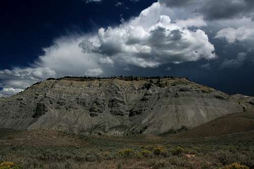
The Gray Hills present an imposing south face, rising steeply in cliffs nearly a thousand feet above the Gros Ventre River. At their base, the river cuts an impressive canyon, sometimes running through gorges with what looks like at least Class 3 whitewater. Atop the crest at about 8100’ (though the highpoint appears to be 8410’), the land stays high for several miles as it slowly rises to meet Mount Leidy and other mountains. The Gray Hills, then, are the ridges immediately north of the river, not the continued highlands north of the crests of the ridges.
Not some climber’s paradise since they are not alpine in nature and their cliffs do not look too appealing (safe) for technical rock climbing, the Gray Hills are nevertheless not something to miss if you enjoy rambling, scrambling, and solitude. As far as I can tell, no maintained trails penetrate to the crest of the cliffs (there is a 4wd road on the northeast side, but it still stays well away from the crest). Access requires a wide ford that is potentially both deep and swift (unless you use a boat to cross, which is possible in many places along the river) or a cross-country hike from the bridge crossing the inlet of Upper Slide Lake. Together, those factors are going to keep almost everyone away.
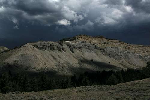
Approaching Storm
The best place to access the crest is probably at the Slate Creek Trailhead, which is about 14 miles in on the Gros Ventre Road (see Getting There). The intersection is signed. Follow this short high-clearance road to a large parking area above the river on its south side. Check river conditions, and if you can make the ford, then cross and hike east/southeast, crossing Slate Creek and maybe Haystack Fork as well (depends on your exact route), to gain the long ridge leading to the highpoint of the Gray Hills.
Between the Slate Creek turnoff and Upper Slide Lake, there are some unimproved roads (some require high clearance, and 4wd is a good idea as well) that lead to the river or to ledges directly above it. Fording at any of these locations and tackling the south face of the Gray Hills directly would be the shortest way to get up but also the hardest and most dangerous, as the terrain is extremely steep, with loose rock and many cliff bands.
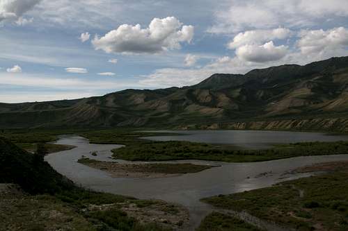
If the river is too high to ford or you just don’t like stream crossings, then the best way to go is to turn left at the upper end of Upper Slide Lake, cross a bridge, and then hike cross-country about two miles to gain a ridge that will take you up to the crest. Beyond the bridge, the road quickly turns into a rugged 4wd affair. To the right of that road, some hills very much like the Gray Hills, though lower, are close by.
Traversing the entire crest would be complicated by the fact that Lightning Creek splits the range about halfway along, but one can detour north to where the drainage is not so deep, cross, and then return south to the crest.
Getting There
From the North: Turn left (east) from U.S. 26/89/187 through Grand Teton National Park onto a paved road (Antelope Flats Road) that is just past the Blacktail Ponds Overlook. If you reach Moose Junction, you have gone too far. Drive about 5 miles to an intersection with another narrow paved road and turn right. At the intersection, there should be a sign indicating that one turns right to reach Kelly. After 2-3 miles of driving south, turn left onto the Gros Ventre Road. If you reach the small community of Kelly or the Gros Ventre Campground even further, you have gone too far and have to turn around.
From the south: From Jackson, take U.S. 26/89/187 through Grand Teton National Park north to Gros Ventre Junction, where you turn right onto a paved road leading to Kelly. At the turnoff to Kelly, the road turns sharply left (north) and reaches the Gros Ventre Road in about 2 miles. Turn right onto that road.
Gros Ventre Road: Some maps mark this as an unpaved road, but it is paved, though not very well, for a few miles. Signs will indicate it is 10 miles to the Red Hills, but it is closer to 11, at least to reach the heart of the area. Along the way, you pass the Gros Ventre Slide (where a section of a mountain collapsed) and Lower Slide Lake (created by natural damming resulting from the slide). The road is easily passable for most cars to the Red Hills area but does have a good deal of washboarding that will mess with traction for vehicles that have light rears or which are going too fast. After the Red Hills, the road makes a bridged crossing of Crystal Creek and starts getting rougher as it heads into sprawling, open Wyoming country that is like something out of a Western. The Gray Hills now come into view and are visible the rest of the way to Slide Lake, 22 miles in.
Approaching Storm
Red Tape, Camping
There are no fees or permits required. Obey posted signs for private property. This is bear country (both black and grizzly), so know and follow the protocol for visiting bear country.
Along the Gros Ventre Road, you can stay at Atherton Creek, Red Hills, or Crystal Creek Campground. These sites charge $10 a night (that is as of July 2009), they have running water and pit toilets, and they have first-come, first-served sites only.
Dispersed camping is widely available unless expressly prohibited in a specific location. Follow regulations about fires and food storage.
Backcountry camping is free, and no permits are necessary.