
-
 18771 Hits
-
 85.65% Score
-
 21 Votes
|
|
Route |
|---|---|
|
|
37.72694°N / 119.54444°W |
|
|
Hiking |
|
|
Summer |
|
|
Most of a day |
|
|
Trail |
|
|
Overview
The Mist Trail from Happy Isles to the top of Nevada Falls is a very popular day-hike in the Yosemite Valley. It follows and crosses the Merced River, passes Vernal Falls and Emerald Pool, and eventually climbs up to the top of Nevada Falls at the base of Liberty Cap. Happy Isles is also the start of the John Muir Trail on its way to Mount Whitney over 200 miles further south. During peak season there are masses walking to Vernal Falls, but the crowd considerably thins out once you continue to the Nevada Falls.Route Description
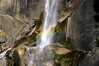
From the trailhead at the Happy Isles (4,040’) the hike gently ascends first south through an oak and pine forest on the north bank of Merced River. The trail bends to the east around Grizzly Peak (6,219’) with Illilouette Gorge and Fall to the right. After about 0.8 miles you will cross the river over the Vernal Fall Bridge and have a first glimpse at the 317-foot Vernal Falls upstream. There are restrooms and a water fountain nearby. Shortly after you crossed the bridge, the Mist Trail leaves the John Muir Trail to the left. Following the Mist Trail the path climbs steeply south of the Merced River to the top of the Vernal Falls. Depending on the amount of water, you can get soaking wet by the thick mist from the thundering Vernal Falls. Be cautious of the slippery rocks when you climb up.

After about 1.2 miles from the Happy Isles you will reach the top of the Vernal Falls (5,040’). Before the Merced River plunges down Vernal Falls it gathers in the deceptively quiet Emerald Pool. A seemingly inviting rocky slope down into the pool called the Silver Apron may be tempting. Do not attempt it! Once inside the Emerald Pool you will be washed over the cliff in seconds. Several people have been killed this way. After 1.5 miles you cross the Silver Apron Bridge to the north side of the Merced River again. The hike now considerably steepens on the south slopes of Mt. Broderick (6,706’) and Liberty Cap (7,076’) and after several switchbacks you reach the top of the 595-foot Nevada Falls at 2.5 miles, where the path meets again with the John Muir trail (5,960’). From there you can follow the John Muir Trail into Little Yosemite Valley and eventually Half Dome or further into the backcountry, or turn south/southwest to take the John Muir Trail back to Happy Isles.
After crossing the bridge on top of the Nevada Falls you will reach a junction with the Panorama Trail (2.7 miles) that leads to Illilouette Fall and Glacier Point. Take the John Muir Trail to the right and continue descending until you reach the Vernal Fall Bridge after about 5 miles. Another 0.8 miles brings you back to the Happy Isles. Overall the loop is 5.8 miles with an elevation gain of 1,950’.
Getting There
There are several accomodations in Yosemite Valley. A shuttle bus brings you from from several locations within Yosemite Valley to the Happy Isles Nature Center (Stop 16). Curry Village is the nearest campsite.Current Weather
Essential Gear
No specific gear is necessary on that hike. Lug-soled boots are always recommended.External Links
Yosemite ValleyYosemite Valley Accommodations