
-
 8798 Hits
-
 84.82% Score
-
 19 Votes
|
|
Mountain/Rock |
|---|---|
|
|
46.69761°N / 12.10719°E |
|
|
Hiking, Scrambling |
|
|
8028 ft / 2447 m |
|
|
Overview
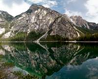
 Herrenstein / Sasso del Signore seen from Seekofel / Croda del Becco / Sas dla Porta Herrenstein / Sasso del Signore seen from Seekofel / Croda del Becco / Sas dla Porta |
Herrenstein / Sasso di Signore is one of the few mountains of the Rosskopf Group of the Prags / Braies Dolomites, which can be hiked or climbed. Or - for that matter - the summit of which deserves to be climbed. It is the north-westernmost mountain of the group and towers 1000m above Pragser Wildsee / Lago di Braies. In contrast to its direct neighbours - Gametzalpenkopf / Sella dei Camosci and Großer Roßkopf / Campo Cavallo it consists of far more solid rock though this doesn't place it in the top grades still. Like in all of the Prags / Braies Dolomites you find huge scree fields around the mountain, bearing witness of the soft composition of the underlying limestone rock.
 |  |  |  |
Herrenstein / Sasso di Signore consists of two summits - Herrenstein proper and the neighbouring Herrensteinturm, a small and narrow tower. Both can be reached from Pragser Wildsee / Lago di Braies by a 1000m 3h scramble to Weißlahnsattel / Sella di Lavinia Blanca, a saddle about 150m beneath the summit to the south.From there a steep scree scramble takes you to the saddle which separates the two summits from each other, from where a short exposed but protected section leads to the top. Due to the relatively high difficulty most hikers pass the mountain and rather head to the higher Großer Roßkopf / Campo Cavallo to the south-west.
 |  |  |  |
Herrenstein / Sasso di Signore - usually such a name would signify some local overlord, being commemorated by the mountain. Here, however you can be sure that the translation would be something like "Mountain of the Lord". Accompanied by lower summits to its western side, the 12 Apostles, Herrenstein / Sasso di Signore is the highest mountain of its particular sub-sub group - the Lord and his Disciples.
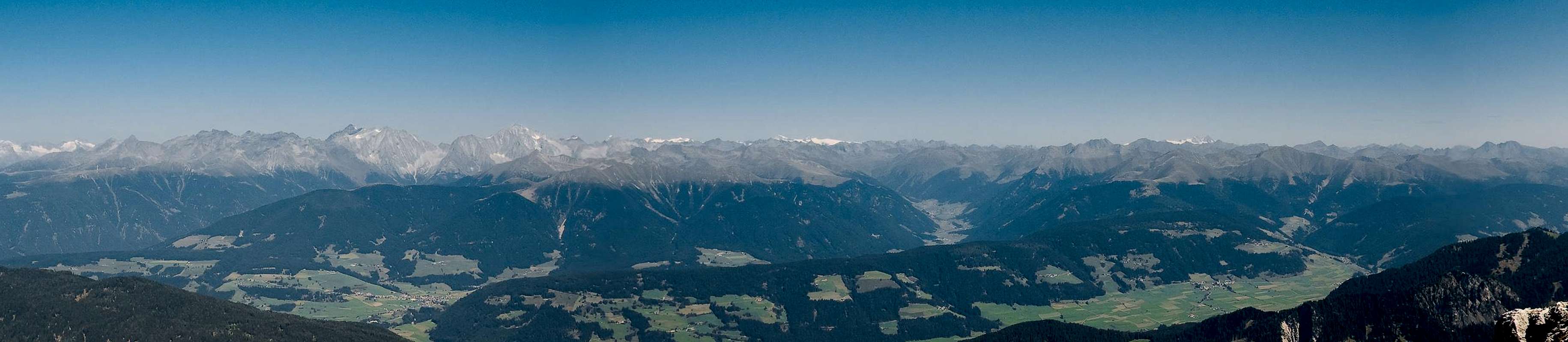
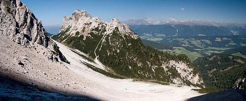
Panoramic view
  |
Getting There
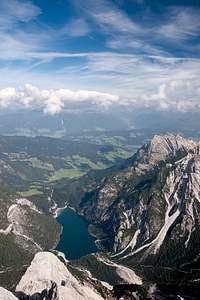
 Herrenstein / Sasso del Signore see during the traverse from Großer Roßkopf / Campo Cavallo
The best trailhead for Herrenstein / Sasso di Signore is at Pragser Wildsee / Lago di Braies in the west of the mountain.
From The North
- Take A22 Brenner Motorway to exit Brixen / Bressanone
- Turn off onto SS49 east to Bruneck / Brunico or Toblach / Dobbiaco
From Austria (East)
- Take A12 Inntalautobahn to exit Kufstein.
- Turn onto B178, later B161 south in direction Kitzbühel.
- At Mittersill B161 turns into B108 which heads through Felbertauern Tunnel.
- Take B108 until Lienz were you turn right (west) onto E66 which on the border crossing turns into SS49 to Toblach / Dobbiaco and Bruneck / Brunico.
From Udine
- Take A23 north to exit Carnia.
- Turn off onto SS52 which leads through several detours to Innichen / San Candido
- Turn east on SS49 to Toblach / Dobbiaco and Bruneck / Brunico.
From Venezia
- Take motorway S27 north towards its end near Belluno.
- Turn onto SS51 towards Cortina d’Ampezzo and on to Toblach / Dobbiaco.
Red Tape
In 1980 an area of 25680ha has been set aside for the Natural Park Fanes Sennes - Prags. You are required to treat the Natural Park with care: leave animals and plants in their place, use trails (especially when mountain biking), and take the official open roads with your car.For more information you can look at the parks official website
Be prepared to pay a small fee (3€) for the parking lot at the trailhead at Pragser Wildsee / Lago di Braies.
Accommodation
For hotels and apartments have a look at the websites of the towns and cities of the area:Weather Conditions
Maps & Books
Books
The Prags Dolomites / Dolomiti de Braies are not as well covered in terms of Guidebooks. The list below offers the German books I know of dealing with the area but there certainly are more, especially Italian ones.
- Dolomiten 5 - Sexten - Toblach - Prags
F. Hauleitner
Rother Verlag
ISBN: 3 7633 4199 4
- Dolomiten
P. Fleischmann
Kompass Verlag
ISBN: 3 8705 1409 4
Sextener Dolomiten extrem - Alpenvereinsführer
R. Goedeke
Rother Verlag
ISBN: 3 7633 1255 2
Maps
The most commonly used maps are the ones by Kompass and by Tabacco. The Kompass one is good as an overview map while the Tabacco one offers more details.
- Bruneck - Toblach / Brunico Dobbiaco
Kompass Map WK 57
ISBN: 3 85491 064 9
Scale: 1:50000
- Dolomiti di Braies / Pragser Dolomiten / Marebbe / Enneberg / Plan de Corones / Kronplatz
Tabacco Map 031
Scale: 1:25000