
-
 6335 Hits
-
 82.48% Score
-
 15 Votes
|
|
Mountain/Rock |
|---|---|
|
|
46.71264°N / 12.03442°E |
|
|
Hiking, Skiing |
|
|
Summer, Fall, Winter |
|
|
8422 ft / 2567 m |
|
|
Overview
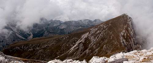 South slope and north face - the typical form of Maurerkopf / Monte Muro South slope and north face - the typical form of Maurerkopf / Monte Muro |
To the north the Prags / Braies Dolomites are bounded by the wide Pustertal Valley / Val Pusteria. While the north-eastern part of the mountain group is remarkably insignificant, the north-western part forms a solid barrier towards the valley. Here six characteristic mountains rise in a single line: the Olanger Köpfe. Named after the village of Olang / Valdaora ath their northern bases, the six mountains all show impressive, if somewhat crumbling, north faces. Named from west to east they are Piz de la Perez / Pizzo delle Pietre (2507m), Dreifingerspitze / Punta Tre Dita (2479m), Flatschkofel / Col Vallaccia (2416m), Maurerkopf / Monte Muro (2567m), Hochalpenkopf / Cima dei Colli Alti (2542m) and Kaserkopf / Punta Casera (2414m).
Among these Maurerkopf / Monte Muro takes a special place. Not only is it the highest of the five mountains, it also is the central one and since it is twin-peaked Maurerkopf / Monte Muro also is the most impressive one. Still, it sees less ascents than its direct neighbours, Hochalpenkopf and Flatschkofel, mainly because the regular hiking trail across Olanger Köpfe leaves it out. In order to get to the summit you either need to go the long way through Lapaduresjoch, a saddle to the far west of the summit or you have to climb Hochalpenkopf first, and then traverse a brittle but very steep ridge. The final ascent to the mountain is easy from either side, since it traverses the grass-covered south slopes of the mountain. Both routes can be combined in a large loop trail, which covers 1500m in elevation when started from Pragser Wildsee / Lago di Braies.
 |  |
These slopes are most likely the main attraction for climbing Olanger Köpfe in the summer. Here a big variety of halfway domesticated animals graze freely, making the area, Hochalpe / Colli Alti one of the largest mountain pastures in the Alps. It is famous for the many horses, which live there in summer and which can be anything between trusting, curious and outright intrusive. In spring and early summer the pasture turns into a giant bed of wildflowers, another reason for its popularity.
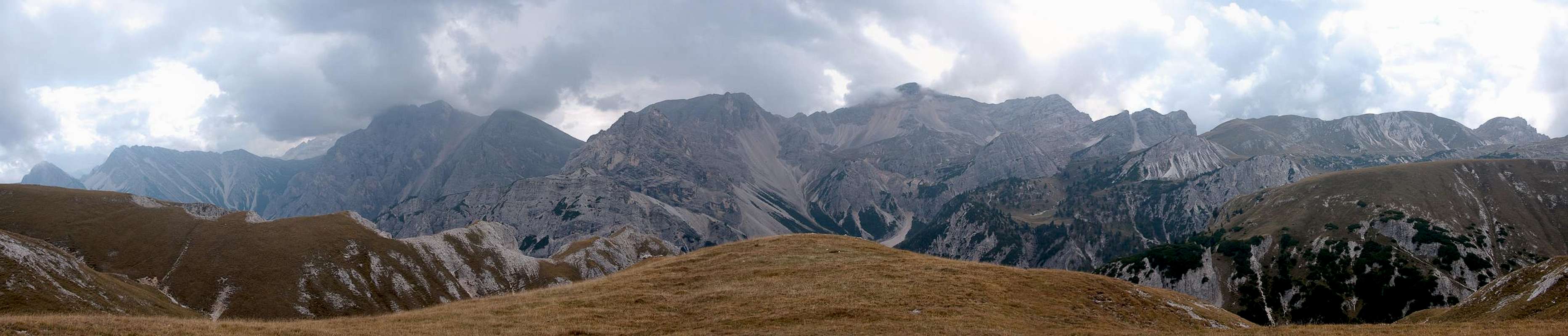
Maurerkopf / Monte Muro, as well as his neighbours, commands good views across Pustertal / Val Pusteria towards the glaciated mountains of Hohe Tauern, especially the nearby Rieserferner Group / Vedrette di Ries. To the south, right across the Grünwaldtal are the impressive north faces of the Monte Sella di Sennes - Seekofel Group, lined up on an east-west ridge.
Panorama Prags / Braies Dolomites
  |
Getting There
 |
The best trailhead for Maurerkopf / Monte Muro is at Pragser Wildsee / Lago di Braies in the east of the mountain. It can be easily reached from Toblach / Dobbiaco.
From The North
- Take A22 Brenner Motorway to exit Brixen / Bressanone
- Turn off onto SS49 east to Bruneck / Brunico or Toblach / Dobbiaco
From Austria (East)
- Take A12 Inntalautobahn to exit Kufstein.
- Turn onto B178, later B161 south in direction Kitzbühel.
- At Mittersill B161 turns into B108 which heads through Felbertauern Tunnel.
- Take B108 until Lienz were you turn right (west) onto E66 which on the border crossing turns into SS49 to Toblach / Dobbiaco and Bruneck / Brunico.
From Udine
- Take A23 north to exit Carnia.
- Turn off onto SS52 which leads through several detours to Innichen / San Candido
- Turn east on SS49 to Toblach / Dobbiaco and Bruneck / Brunico.
From Venezia
- Take motorway S27 north towards its end near Belluno.
- Turn onto SS51 towards Cortina d’Ampezzo and on to Toblach / Dobbiaco.
Red Tape
 Maurerkopf / Monte Muro west slopes as seen from Flatschkofelscharte
In 1980 an area of 25680ha has been set aside for the natural Park Fanes Sennes - Prags. You are required to treat the Natural Park with care: leave animals and plants in their place, use trails (especially when mountain biking), and take the official open roads with your car.
For more information you can look at the parks official website
Be prepared to pay small fees (3€) for the parking lot at the trailhead.
Accommodation
For hotels and apartments have a look at the websites of the towns and cities of the area:Weather Conditions
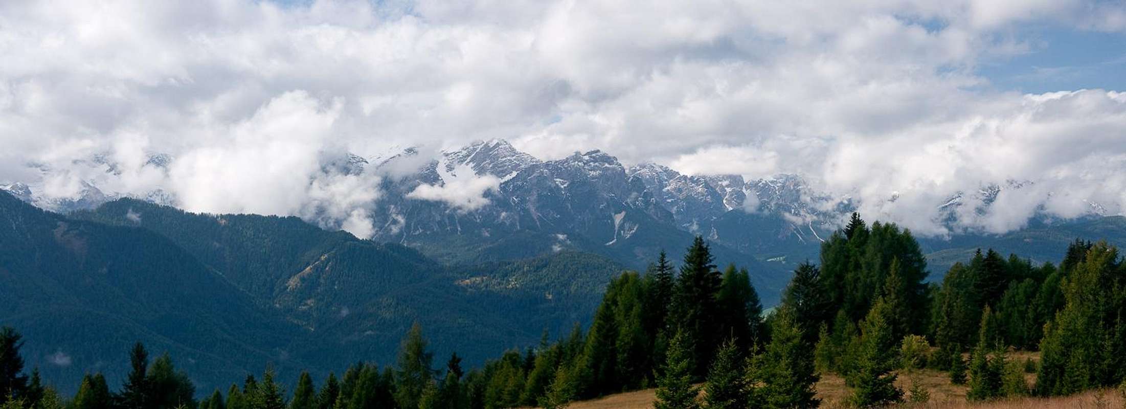
 Kaserkopf, Hochalpenkopf and Maurerkopf
 Maps & Books
Books
The Prags Dolomites / Dolomiti de Braies are not as well covered in terms of Guidebooks. The list below offers the German books I know of dealing with the area but there certainly are more, especially Italian ones.
- Dolomiten 5 - Sexten - Toblach - Prags
F. Hauleitner
Rother Verlag
ISBN: 3 7633 4199 4
- Dolomiten
P. Fleischmann
Kompass Verlag
ISBN: 3 8705 1409 4
Sextener Dolomiten extrem - Alpenvereinsführer
R. Goedeke
Rother Verlag
ISBN: 3 7633 1255 2
Maps
The most commonly used maps are the ones by Kompass and by Tabacco. The Kompass one is good as an overview map while the Tabacco one offers more details.
- Bruneck - Toblach / Brunico Dobbiaco
Kompass Map WK 57
ISBN: 3 85491 064 9
Scale: 1:50000
- Dolomiti di Braies / Pragser Dolomiten / Marebbe / Enneberg / Plan de Corones / Kronplatz
Tabacco Map 031
Scale: 1:25000