
-
 5744 Hits
-
 83.1% Score
-
 16 Votes
|
|
Mountain/Rock |
|---|---|
|
|
46.68633°N / 12.11843°E |
|
|
Hiking, Scrambling |
|
|
Spring, Summer, Fall, Winter |
|
|
8396 ft / 2559 m |
|
|
Overview
 Grosser Rosskopf / Campo Cavallo as seen from the south-west Grosser Rosskopf / Campo Cavallo as seen from the south-west |
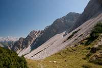
Though not the highest summit, Grosser Rosskopf / Campo Cavallo (sometimes also Großer Rosskofel) is the central mountain of the Rosskopf Group of the Prags / Braies Dolomites. It is a typical example for the mountains of this greater range as it has a shallow south face and a labyrinthine north face of severall 100m height, consisting of an endless nomer of towers and pinnacles. There is no such thing as "rock quality" - the mountain consists of sand, rubble and choss.
 |  |  |
Still Grosser Rosskopf / Campo Cavallo is a rather popular mountain, thanks to its central location. You can expect wonderful views on a fine day but also large crowds on the summit plateau. There are numerous routes, which lead to the mountain, all long and with a lot of elevation gain but certainly easy. The two most reasonable trailheads, Pragser Wildsee / Lago di Braies and Brückele / Ponticello are popular destinations themselves and can be easily reached by car. For both you will have to pay small parking fees (3€).
 |  | 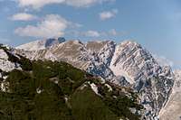 |
Grosser Rosskopf / Campo Cavallo overlooks the northern valleys of the Prags / Braies Dolomites, which open up into the wide Pustertal Valley / Val Pusteria Thus it commands good faraway views of the Hohe Tauern Group, sometimes as far as Großglockner. Nearby you have the Sexten / Sesto Dolomites and of course the Prags / Braies Dolomites with the wide karst plateaus of Fosses, Fanes and Sennes. The most picturesque route runs across the northern parts of these plateaus from Pragser Wildsee / Lago di Braies climbing the mountain from the south.
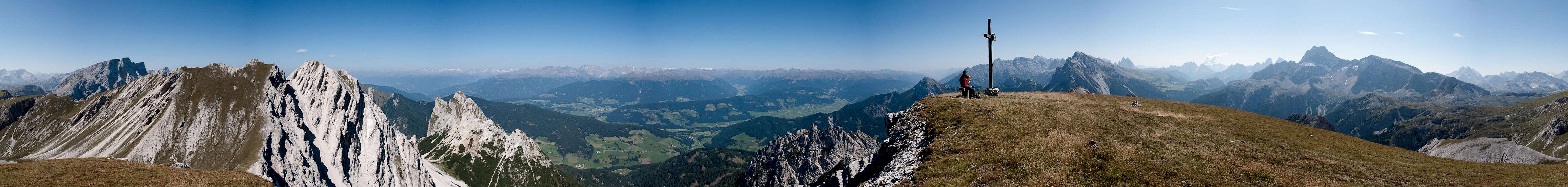
360° Summit Panorama
  |
Getting There
 |
The best trailheads for Großer Rosskopf / Campo Cavallo are at Pragser Wildsee / Lago di Braies in the north-west and Brückele / Ponticello in the south east. They can be easily reached from Toblach / Dobbiaco.
 |  |  |
From The North
- Take A22 Brenner Motorway to exit Brixen / Bressanone
- Turn off onto SS49 east to Bruneck / Brunico or Toblach / Dobbiaco
From Austria (East)
- Take A12 Inntalautobahn to exit Kufstein.
- Turn onto B178, later B161 south in direction Kitzbühel.
- At Mittersill B161 turns into B108 which heads through Felbertauern Tunnel.
- Take B108 until Lienz were you turn right (west) onto E66 which on the border crossing turns into SS49 to Toblach / Dobbiaco and Bruneck / Brunico.
From Udine
- Take A23 north to exit Carnia.
- Turn off onto SS52 which leads through several detours to Innichen / San Candido
- Turn east on SS49 to Toblach / Dobbiaco and Bruneck / Brunico.
From Venezia
- Take motorway S27 north towards its end near Belluno.
- Turn onto SS51 towards Cortina d’Ampezzo and on to Toblach / Dobbiaco.
Red Tape
In 1980 an area of 25680ha has been set aside for the natural Park Fanes Sennes - Prags. You are required to treat the Natural Park with care: leave animals and plants in their place, use trails (especially when mountain biking), and take the official open roads with your car.For more information you can look at the parks official website
Be prepared to pay small fees (3€) for the parking lots at the two trailheads.
Accommodation
For hotels and apartments have a look at the websites of the towns and cities of the area:Weather Conditions
Maps & Books
Books
The Prags Dolomites / Dolomiti de Braies are not as well covered in terms of Guidebooks. The list below offers the German books I know of dealing with the area but there certainly are more, especially Italian ones.
- Dolomiten 5 - Sexten - Toblach - Prags
F. Hauleitner
Rother Verlag
ISBN: 3 7633 4199 4
- Dolomiten
P. Fleischmann
Kompass Verlag
ISBN: 3 8705 1409 4
Sextener Dolomiten extrem - Alpenvereinsführer
R. Goedeke
Rother Verlag
ISBN: 3 7633 1255 2
Maps
The most commonly used maps are the ones by Kompass and by Tabacco. The Kompass one is good as an overview map while the Tabacco one offers more details.
- Bruneck - Toblach / Brunico Dobbiaco
Kompass Map WK 57
ISBN: 3 85491 064 9
Scale: 1:50000
- Dolomiti di Braies / Pragser Dolomiten / Marebbe / Enneberg / Plan de Corones / Kronplatz
Tabacco Map 031
Scale: 1:25000