
-
 4309 Hits
-
 78.68% Score
-
 10 Votes
|
|
Mountain/Rock |
|---|---|
|
|
49.19626°N / 7.75481°E |
|
|
Sport Climbing, Toprope |
|
|
Spring, Summer, Fall |
|
|
787 ft / 240 m |
|
|
Overview
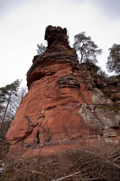 Rappenfels western tower Rappenfels western tower |
For most people, who drive by the village of Hinterweidenthal, it is little more than a traffic light intersection on a big highway, B10 which runs from Landau to Pirmasens. In the absence of motorways this highway has been extended to three or four lanes and a traffic light naturally tickles the patience of any driver. A little to the west of the village you might wonder about a sandstone formation, which is visible for a brief period, but Kaltenbacher Teufelstisch vanishes as quickly as it comes into view. Only if you turn off B10 onto L427 will you realize what this village stands for - a climbing hotspot, with several wonderful sandstone towers, which pop up all around the village centre.
Right in its middle, high above L427, there is a formation, which is almost hidden from view. Rappenfels it is called, and since this name is rather common in the greater Südpfalz Area, the name of the village usually goes in front. Like most of the Hinterweidenthal crags, Rappenfels is a standalone tower, leaning out of the neighbouring mountain above the village. It has two features, a smaller eastern tower behind the higher western one, with a chimney separating both. Together they look like a horse with its rider, a possible explanation for the name (Rappe = black horse).
 | 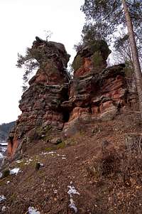 |  |  |
The formation is easy to get to and actually very popular among hikers. There are two trails which pass it, one to its base and one climbing towards the gap between the eastern tower and the mountain in its back. Moreover, the village authorities see to it that the formation remains visible from the village centre, cleaning away all the undergrowth (mainly blackberry bushes) at irregular intervals. Currently most of the formation is open, which also makes it much more easily accessible than usual.
As for climbing routes, there are but a few, all of which are not exactly difficult. The normal route doesn't exceed UIAA II, while one of its variations reaches a solid IV+. For scramblers, the chimney route towards the lesser eastern tower id of interest, as well as the balancing act around the whole formation, which makes use of a ring-like ledge all around. Both routes are graded I.
Climbing Routes on Rappenfels
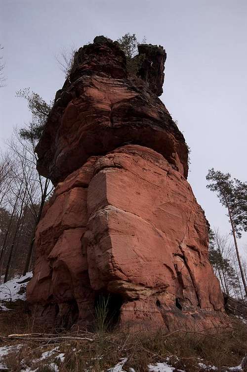 Rappenfels westernmost edge
The following table has a link to the tour database of the PK, where you can find the grades for the free routes plus additional information. Here is the link to the complete route database.
| Feature | Routes link | Summary |
| Rappenfels | Hinterweidenthaler Rappenfels | 4 routes with variations ranging from 1 - 4+ |
Getting There
Hinterweidenthaler Rappenfels is located directly above the village of Hinterweidenthal. The best starting point is in Hinterweidenthal, either near the little train station or on the village square. You'll have to hike for about 5 - 10 minutes (just head for the village centre, turn into Schulstrasse, then head up the stairs to the left and return via Waldstrasse. At the end of the road a dirt road takes you to the base of the crag, while a hiking path to the right takes you to its top).Hinterweidenthal is pretty deep inside the Pfälzerwald area so itineraries from the nearest airports Frankfurt and Stuttgart tend to be lengthy:
From Frankfurt
There are two possible routes which both take equally long- Via Ludwigshafen
- From Frankfurt take motorway A5 southward to Darmstadt.
- There change to A67 south.
- At Viernheimer Dreieck turn onto A6 west.
- Leave it at Frankenthaler Kreuz for A61 south.
- At Mutterstädter Kreuz take A65 south until you reach Landau.
- At Landau turn on B10 west.
- At Hinterweidental turn onto B427 south and immediately follow the signs to Teufelstisch (right).
- Don't cross the railway line but search for a parking space near the crossing. The next one is to the right near the station, the village square is 200m further onwards to the left.
- Via Kaiserslautern
- From Frankfurt take motorway A3 west
- At Mönchhofdreieck turn onto A67 south
- At Rüsselsheimer Dreieck take A60 west
- At Kreuz Mainz Süd take A63 south
- At Kreuz Kaiserslautern turn onto A6 west
- At Kreuz Landstuhl turn onto A62 south
- At Pirmasens turn onto B10 east
- At Hinterweidental take B427, then follow the instructions above
From Stuttgart
- Take motorway A8 to Karlsruhe
- At Karlsruher Dreieck turn north onto A5
- Take the next exit to head for A65
- At Kandel you can leave onto B427 which will lead you directly to Dahn. However the detour to Landau and B10 will take less time as the roads are better (three or four lanes).
- At Hinterweidental take B427, then follow the instructions above
Red Tape
Yes, there is red tape and lots of it. The sandstone of Südpfalz forms lots of caves and overhangs. Though this makes it most interesting for climbers, two species of birds of prey compete for this habitat: the peregrine falcons and the eagle owls. Both are endangered and wherever there is a eagle owl pair found nesting in the sandstone the crag will immediately be closed. Generally this closure lasts from the beginning of each year through Aug. 1st. If breeding is not successful the closures will be cancelled even before that date. For a list of closures see the Closure List of PK. The Schillerfelsen are so close to the nearest houses of Dahn, that usually birds don't nest there. However, please adhere to "stop signs" if there are any. |  | 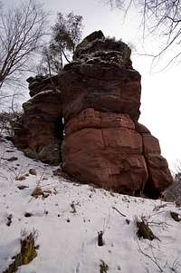 |
The use of magnesia is not allowed in the whole Südpfalz region. This is rather a directive or an arrangement than an outright law. Thus you probably will get away with using it but do so only when absolutely necessary. Magnesia closes the pores which you find in the sandstone and together they form a smooth surface which will get very slippery in wet conditions. The rule of thumb is to use magnesia in the highest difficulty sections and only extremely sparingly.
A list of guidelines can be found here (in German).
Accommodation
Hinterweidenthal has only a few inns and one hotel. The latter is to the east of the village on B10 and certainly is pretty noisy. A few kilometres to the south, at Dahn you can find everything that you need. See the following link:Dahn tourist information site
Dahn has a youth hostel and several campgrounds. The closest one is between Hinterweidenthal and Dahn at Neudahner Weiher.
Weather Conditions
Maps & Books
Maps
As for maps there is a good overview map (1:50000) by Kompass Verlag but the best ones are the official topographic maps by the state government of Rheinland Pfalz, scaled 1:50000, 1:25000 and 1:5000. All official maps can be found on the web page of Landesvermessungsamt Rheinland Pfalz
1:50000
- Naturpark Pfälzer Wald
Kompass Map WK766
ISBN: 3-85491-523-3
- Pirmasens Süd<
LVA RLP Map L6910
ISBN: 3-89637-193-2
1:25000
- Dahn
LVA RLP Map 6812
ISBN: 3-89637-147-9
Books
There are a number of climbing guidebooks on the region of Südpfalz. The best ones, however, have been published privately and are sold only in selected bookshops of the region.
- Hiking
- Pfälzerwald
B. & J.-Th. Titz
Rother Verlag
ISBN: 3-7633-4268-0 - Klettern im Buntsandstein
U. Daigger, H.-J. Cron
Westpfälzische Verlagsdruckerei St. Ingbert
ISBN: 3-00-0155457-4
- Pfalz - Klettern im Buntsandstein des Pfälzer Felsenlands
J. Richter, S. Tittel
Panico Alpinverlag
ISBN: 978-3-936740-41-7
- Pfalz ++, Klettern im Buntsandstein
R. Burkard, P. Weinrich
Published privately
- Klettern im Naturpark Pfälzerwald
Naturfreunde Lambrecht
Published privately - Pfalz & Nordvogesen en bloc
A. Wenner, Y. Corby, I. Bald
Panico Verlag
ISBN: 3-936740-19-4
  Climbing Guidebook |
Climbing