
-
 20018 Hits
-
 91.45% Score
-
 35 Votes
|
|
Mountain/Rock |
|---|---|
|
|
43.53808°N / 115.04486°W |
|
|
Camas |
|
|
Hiking, Scrambling |
|
|
Spring, Summer, Fall |
|
|
9694 ft / 2955 m |
|
|
Overview


Just to the north of the summit is Heart Lake at 8346 feet, which is a good reason in itself to explore the area. Heart Lake is the only real lake for miles around the region. Unlike some neighboring areas like the Sawtooths, the Boise Mountains contain just a handful of alpine lakes. These few lakes of the region are usually found on the north sides of the more prominent peaks. Good examples of this are just north of Steele Mountain, Trinity Mountain, and Ross Peak.

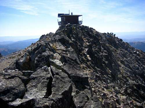
The summit of Iron Mountain contains a fire lookout tower, along with a large concrete slab where perhaps an older structure once stood. The west to northwest side of the summit drops off precipitously and often holds snow in it's dark and steep slots. Lying just to the north-northwest of the summit is a very prominent rock tower that rises 320 nearly vertical feet on it's west side. This rock is clearly denoted on the USGS quad with unusually tight contours. The trail from the South Fork of the Boise River passes just under this rock feature.
Routes

From the Bighorn Campground utilizing the trail the whole way: 9.1miles and 6005 feet gain (one way)
From the Bighorn Campground utilizing the north ridge proper (leaving the trail): 6.3miles and 4951 feet gain (one way)
Lime Creek / Southwest Slopes (Class 2)- from the campground near the junction of Hunter Creek and South Fork of Lime Creek, follow the 4WD path to the Middle Fork of Lime Creek canyon and eventually to Deer Park near Point 7486. From here the trail branches off and switches back to the summit on the open southwest slopes.
From the Hunter Creek / Lime Creek Trailhead: 12.3miles and 5396 feet gain (one way)
Other Routes- the nature of the open slopes and numerous trails around this peak make for many other options. Traversing over from Smoky Dome would be an excellent ridge traverse. The West Fork of Beaver Creek provides another route along with a steep scramble up from Deadwood Creek via Heart Lake. The Bremner Pack Trail from the South Fork of Lime Creek is also a possible option.
Getting There

To access the Beaver Creek / North Ridge Route which starts at the Bighorn
Campground along the South Fork of the Boise River, the drive time from Boise is
approximately 2 hours. This option is usually the best not only because
it's the shortest route to the summit, but the access is really good. During
summer and fall conditions this approach can be done by a low clearance vehicle.
The whole road approach is paved through Featherville and the last 10 miles is
on improved dirt. Take Route 20 north of Mountain Home toward Fairfield.
Just past Cat Creek Summit, take the Pine/Featherville road. Just past
Featherville, the road becomes dirt and just past the Baumgartner CG is Bighorn
CG which is primitive and not signed.
Check the road conditions at: Idaho Transportation Department

Conditions and Season
Conditions may vary greatly. Access is typically from May to November.
The upper South Fork of the Boise River provides good access to many of the Boise mountains in the south central portion of the range. The paved road to Featherville is really useful and unlike much of the region. Still, big snow storms will pound this region like most mountainous areas.


garyerichardson@gmail.com - Aug 27, 2017 2:09 pm - Hasn't voted
Soldier MtnsIron Mountain is at NW end of the Soldier Mountains. I've never heard of Iron or any other of the nearby peaks, some 80 miles from Boise—Steel, Trinity, Smoky Dome, etc.—being placed in the "Boise Mountains."
BeDrinkable - Aug 17, 2018 9:04 am - Voted 10/10
Re: Soldier MtnsDue to the lack of any real geographical separation, the Soldier Mountains are generally considered a subsidiary of the Boise Mountains. Kind of like the Trinities. FWIW, I've never heard of anyone referring to the the Soldiers as anything other than the front rising from the Camas Prairie. Steel has always been a 'Boise Mountains' peak.