
-
 17677 Hits
-
 82.48% Score
-
 15 Votes
|
|
Mountain/Rock |
|---|---|
|
|
43.41337°N / 115.65885°W |
|
|
Elmore |
|
|
Hiking, Scrambling |
|
|
Spring, Summer, Fall, Winter |
|
|
6892 ft / 2101 m |
|
|
Overview

Danskin Peak is similar to many other Boise Mountain peaks in that it has a jeep road leading to the top, a fire lookout, and it's often accessible as soon as March. Danskin is part of a sub-range called the Danskin Mountains which also contains Kepros Mountain and Three Point Mountain. The Danskin Mountains are located in the extreme southwestern portion of the Boise Mountains, and consequently, this area usually has it's snow melt first. To the eager scrambler or explorer, this means that Danskin offers one of the first scrambles of the season after winter.
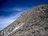
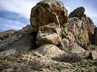
Located north of Mountain Home, Idaho and southwest of Prairie, Idaho, Danskin Peak is the high point of the Danskin Mountains and offers several interesting and varied routes to it's summit. The slopes of Danskin contain hundreds of interesting rock outcroppings, with some as tall as 75 feet. Just to the northeast of Danskin are two of the most impressive rock formations, Steamboat Rock and Cathedral Rock. These rocks tower above the South Fork of the Boise River.

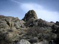
From the summit ridge of Danskin, the views include the Owyhee Mountains in the distance to the southwest, Bennett Mountain near Mountain Home, and the taller peaks of the Boise Range including Two Point Mountain and Trinity Mountain. The summit contains a fire lookout, outhouse, and a road leading up from the north. If approaching from the south, there's an obvious false summit rock formation just southwest of the high point. Danskin is considered a "critical" peak for point to point communications.
Danskin is located just 75 minutes from the Boise area and makes for an excellent, quick exploration.
Routes

Southwest Slopes Rib (Class 2)- Easy Access from the Boise-Mountain Home Area. See the Routes Page for more
Bock Creek- this route ascends from the South Fork of the Boise River area east of the peak. Follow a jeep road and motorcycle trail most of the way.
From the South Fork Parking Area: 5.5 miles and 3446 feet gain (one way)
Other possible routes include the Case Creek approach from the west, the Danskin Lake approach from the north, and the Timber Gulch approach, also from the north.
Getting There
Danskin Peak is located 19.5 miles due north of Mountain Home, Idaho.
Road Approach
Danskin Peak Road can be accessed from Canyon Creek Road in Mountain Home (off
exit 90), or from Ditto Creek and a series of improved roads that branch off
from Oasis and Mayfield, Idaho. FS-167 (or Danskin Peak Road) leaves the
high desert and climbs steeply up and over a small pass. The roads are not
marked in the area. You'll need to utilize visual navigation- look at the
peak and try to get to the southwest area. Given how many dirt roads there
are, you can easily accomplish this.
When wet, be sure to have 4WD, and even then you can get stuck in the mud here easily.
Check the road conditions at: Idaho Transportation Department
Conditions and Season
Usual access to the Danskin Peak area is from March to December, but that can vary according to snow, rain, and mud conditions. The Danskin area, especially the north slopes, often receives several feet of snow accumulation during the winter.
Climate
Nearby Mountain Home Climate Data
| Jan | Feb | Mar | Apr | May | Jun | Jul | Aug | Sep | Oct | Nov | Dec | Annual | |
| Average Max. Temperature (F) | 38.2 | 45.0 | 53.8 | 63.1 | 72.7 | 82.9 | 93.2 | 91.6 | 80.9 | 67.4 | 49.8 | 39.4 | 64.8 |
| Average Min. Temperature (F) | 20.6 | 24.1 | 28.9 | 34.5 | 42.3 | 49.9 | 56.5 | 54.5 | 45.2 | 35.3 | 27.2 | 21.5 | 36.7 |
| Average Total Precipitation (in.) | 1.35 | 0.86 | 1.07 | 0.84 | 0.95 | 0.72 | 0.27 | 0.28 | 0.50 | 0.63 | 1.18 | 1.34 | 9.98 |
| Average Total SnowFall (in.) | 4.4 | 1.9 | 0.3 | 0.0 | 0.0 | 0.0 | 0.0 | 0.0 | 0.00 | 0.0 | 1.0 | 3.2 | 10.7 |
| Average Snow Depth (in.) | 1 | 0 | 0 | 0 | 0 | 0 | 0 | 0 | 0 | 0 | 0 | 1 | 0 |

Links
distressbark - Nov 1, 2012 10:40 am - Voted 10/10
driving directionsSean - I found these directions on a link provided on the page (Trip Report from Dan) - they were very, very accurate and helped me easily navigate an area I'd never been to before. "Take the I-84 EXIT 90. Merge onto I-84 Business Loop heading toward town. At 2.9 miles turn LEFT onto CANYON CREEK ROAD. Reset your odometer. After 4.6(?) miles the pavement ends. At 8.2 miles take the LEFT fork on MAYFIED ROAD (this may be known as Foothill Rd as well, but is marked MAYFIELD). (There is a second fork for Syrup Creek and Immigrant Rd just 100yds up the road that can be ignored.) Reset your odometer. After 6 miles, continue straight (north) on FS-167. At 14.5 miles you reach a reservoir on the east side of the road. Turn right just past the reservoir. Drive east for 3 miles, then turn north (LEFT) at a junction. You will continue north for 1.5 miles, until the road reaches another fork. From this fork, Danskin Peak in 3 miles each way. Park here or continue driving." Also, road signs were marked (signs for Canyon Creek Road, Mayfield Road) which helped. Just thought I'd share this info in case you wanted to update your page. Thanks for putting this one together, we had an awesome time exploring the Danskin Peak area! Thanks, anders