
-
 27332 Hits
-
 81.84% Score
-
 14 Votes
|
|
Mountain/Rock |
|---|---|
|
|
46.04992°N / 113.18968°W |
|
|
Deer Lodge |
|
|
Hiking, Mountaineering, Bouldering, Scrambling |
|
|
Spring, Summer, Fall |
|
|
10641 ft / 3243 m |
|
|
Overview
Rising as the second highest summit in the Anaconda-Pintlers, Mount Evans is a classic mountain with sharp lines and bold colors. Evans wastes no time jutting skyward from Sullivan Ridge and can be seen for miles and miles while traveling the upper end of the Big Hole Valley.Evans is truly a statuesque mountain irregardless of where it is viewed from. Only Warren Peak and Great White Peak (Peak 10282) may rival the rugged and dramatic features of Mount Evans. From grays, to reds, to copper, Evans has the most distinctive coloring of any mountain in the A-P's.
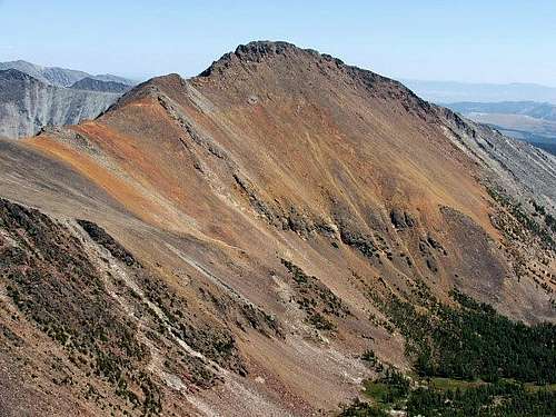 Mount Evans
Just to the west of Evans sits Mount Howe while the more popular and more frequently climbed Mount Haggin lies just to the east. From Evans' summit you can see one of Montana's favorite playgrounds - Georgetown Lake. The graceful profile of West Goat Peak rises further to the west and with haze free skies, many of the northern Beaverhead Peaks can easily be identified. Just off to the southeast, the 11000' summits of Tweedy and Torrey rule like kings over the East Pioneers.
For those who want to get away from everything, a trip to the A-P's to climb Mount Evans will offer challenging scrambling on any approach to the summit and a distinct sense of 'no civilization' wilderness.
Getting There
Seymour Creek Road Seymour Creek Trail access (South route)At the junction of Hwy 1 and Hwy 569, east of Anaconda, turn south on Hwy 569 and head for Wisdom. From the junction it is 19 miles to Seymour Creek Road (FR 934) which does not have a sign until you are 1/4 mile up Seymour Creek Road. However, there is a National Forest entrance sign just prior to the turnoff.
Travel just under 7 miles to the end of the road where the trailhead for Seymour Creek Trail 131 is located.
Dry Creek Road 2483 Sullivan Ridge access (South route)
I believe this road is the best route to get you closest to the vicinity of Sullivan Ridge. However, I have only been 3 to 4 miles up it. You may have to do some trial and error to find the best spur road to get you to a starting point. Don't count on finding any road signs once off the pavement.
 Mount Evans
To get to Dry Creek Road, take Hwy 1 east from Anaconda or west from Butte and turn onto Hwy 569 located just to the east of the famous Anaconda smoke stack. There is a sign marked for Wisdom here. From Missoula take the Warm Springs exit near mile marker 201 which will take you within a mile of Hwy 569. This paved road crosses the Continental Divide but has some serious potholes in the upper sections. From the top of the divide continue 3.2 miles to signed Dry Creek Road.
From Wisdom or I-15 take Hwy 43 to Hwy 569 and follow it north to the turnoff for Dry Creek Road.
Hwy 1 Trail 44 access (North route)
From Anaconda drive west on Hwy 1 for 10 miles to Spring Hill and turn south on Twin Lakes Creek Road (FR 5131). Go 3 miles and turn left onto FR 171 and travel 1/2 mile to the National Forest Boundary where you will find Trail 44.
Summit Routes
Seymour Creek Trail Class 3Hike up Seymour Creek Trail and after only 1/4 to 1/2 mile head cross country right up the hillside. You will gain roughly 1200' as the ridge rounds off.
Your next step will be to drop 300' into the Sullivan Creek drainage. From here pick your best spot to gain Evans' southeast ridge (Sullivan Ridge).
When taking on the final ridge section to the summit stay to the left (Mount Howe side). When the rock turns red, cross over to the right side of the ridge (Mount Haggin side) and gain the summit.
 Mount Evans
Starting elevation: 6800'
Round trip elevation gain: 4400'
Round trip distance: 9 miles (more or less depending on route)
Dry Creek Road Class 3
Your goal is to drive as far as you can up into the drainage to the northeast of Sullivan Ridge. Option 1 is to gain Sullivan Ridge and then work your way up to the summit. Option 2 would be to hike all the way up the drainage and then pick your best spot to gain Evans' northeast ridge, then gain the summit.
Trail 44 Class 3
Head south on Trail 44 and at about 3 miles take the trail fork off to your left which is below Lower Twin Lake. Continue up to Lake of the Isle and then further to the unnamed lake at 8750'.
From here gain the saddle at 9600' to the northeast of Mount Evans and pick your best route along the ridge to the summit.
Starting elevation: 6900'
Elevation gain: 3700'
Round trip distance: 13 miles
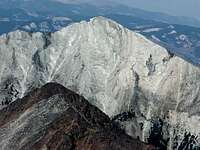 Great White Peak
Camping
For a south side approach there is a USFS campground at Lower Seymour Lake which is located just 1/2 south of Seymour Creek Trail 131.If you are heading up Dry Creek Road, you may have to contend with open range cattle, otherwise you can pick your own spot for the night.
For a north side approach there are two USFS campgrounds located in the Spring Hill area just off of Hwy 1. Spring Hill and Warm Springs are both near Twin Lakes Creek Road but can be busy places due to their proximity to Georgetown Lake.
 Mount Evans sunrise
Red Tape
Parts of the A-P's have pack animal and stock regulations, otherwise this country is wide open for backcountry exploration.When to Climb
For southern approaches you should be able to scramble to the summit in June. A northern approach via Lake of the Isle probably a little later as you get into July. Mount Evans