
|
|
Mountain/Rock |
|---|---|
|
|
34.37630°N / 85.83440°E |
|
|
21457 ft / 6540 m |
|
|
Overview
Zangser Kangri is the highest peak within the central Changtang. Its altitude has been measured in 1997 by a handheld GPS as 6551m, which is roughly supported by evaluations of SRTM data. Other sources claim an altitude of 6450m for the main peak.The high elevation of the present Changtang has resulted from several million years' uplifting during the formation of the Himalayans starting in the Pliocene. So far, it has raised 3500-4000m. The Changtang (Tibetan, translates to "the northern plain") today is a closed plateau surrounded by the Kunlun mountain range to the North, the Kalakunlun to the West, and the Gangdisi-Liangqi Tanggula to the South.
The topography of the Changtang consists mainly of plateau plains (basins and lakes) and wavelike hilly plains, where mountains are discretely distributed with altitude differences ranging from 200 to 600m. Some hills and mountains have been created by volcanic eruptions. Several snow- and glacier-covered high peaks stand out from this 'plain', among which Zangser Kangri is the highest.
The Changtang is characterized by a closed water system. No rivers run into or out of the central Changtang. Therefore, many saline lakes can be found, and although the region as a very low annual precipitation, soils get very boggy in summer time.
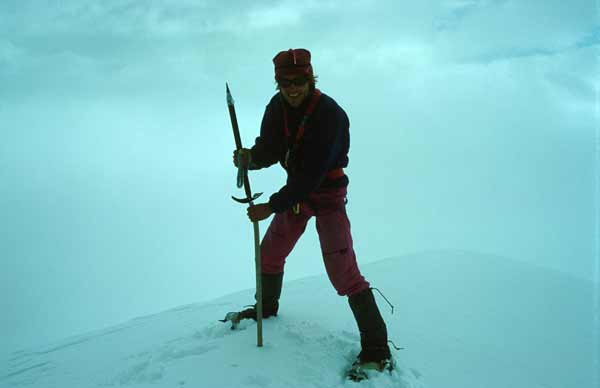
The Zangser Kangri massif is made up by several peaks. Zangser Kangri main peak has been climbed on July 6th 1997 (published in The American Alpine Journal, 1998, Vol 40. pages 124 -130), and team of Tibetan mountaineers had climbed peaks of Zangser Kangri already in May 1992.
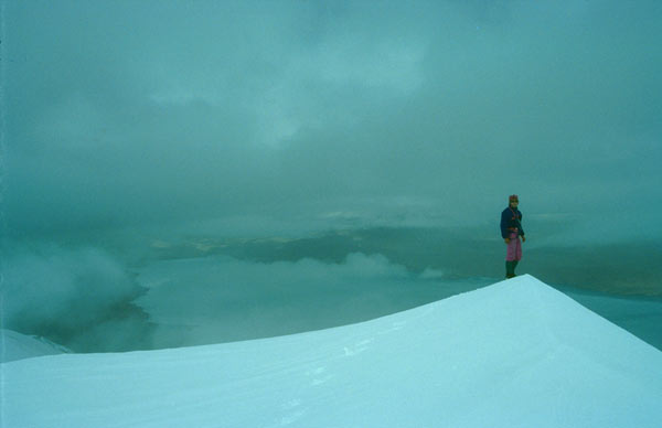
Stefan Simmerer on the summit of Zangser Kangri, Burog Co in the background.
Getting There
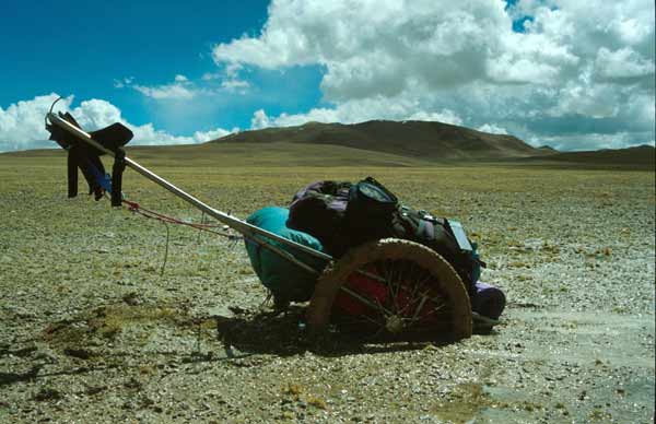
Zangser Kangri is among the most desolated mountains in the world. It is located in the middle of the Changtang, the Tibetan High Plateau. Located at the West side of Burog Co, Zangser Kangri is the highest peak of the central Changtang, higher mountains are only locaed in the Kunlun Shan forming the Northern natural boundary of the Changtang, and in the Gandise Shan to the South.No roads or tracks lead directly up to the mountain, therefore getting there can be an adventurous expedition in its own.
Best access probably is from the South, starting at the Amdo-Gertse road near Dongco. A mining road leads up to Gomo Co, from there on it is roadless wilderness, but the terrain seems suitable for truck driving. According to Stefan Simmerer, the travel time with a standard truck from Dong Co to Burog Co could be approximately three days.
In 1997 Stefan Simmerer and Frank Kauper walked to the Zangser Kangri massif in a 22-day strenuous hike, often held back by large areas of muddy soils:
When to Climb
Zangser Kangri itself is technically not difficult to climb, it is more of a walk-up in deep snow than real climbing (crampons, necessary, ice axe and rope recommended).Peaks of the Zangser Kangri massif have successfully been climbed in months May and July, but access to the mountain in summer months is very difficult due to large areas of boggy soils.
Autumn or winter months allow better acess to Burog Co and the mountain (due to frozen soils), but climbing may be more difficult in the harsh winter months (due to colder temperatures and high winds). Spring time is not recommended due to heavy snow-fall in the Changtang region and more unstable weather conditions.
Successful climbers (Simmerer, Kauper 1997):
Camping
 Ice left over from winter at a saline lake
Camping is possible anywhere, especially at the mountain itself there is plenty of wonderful camp spots.
The region around Zangser Kangri does not show signs of permanent human settlements, although recently there are more nomads moving further into the Chang Tang and may be living within sight of the mountain part time of the year. On the way to the mounain massif there are numerous permanent settlements of Tibetan nomads. In recent years, more and more of the wide grassland is being fenced to divide grazing grounds among nomads - also on route to Zangser Kangri these fencing efforts may be encountered.
In several regions of the Changtang it can be difficult to find water. Most lakes in the area are saline and large parts of the landscape are desert-like. Sweet water springs can often be found on shallow saddles and at the foot of small hills.
The Changtang is full of fascinating wild life: herds of Tibetan wild ass, Tibetan antelopes, wild yak, wolves, etc. The lakes are visited by many different birds, among them bar-headed geese, or black-necked crane.
Mountain Condition
There are no precise weather reports available for this region of the world. Climbers are recommended to make use of the generally stable weather situation for the Changtang in late autumn.In spring and summer heavy thunderstorms are very frequent.
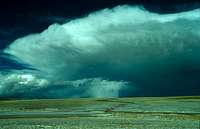 Big thunderstorm Big thunderstorm |
 Thunderstorm clouds Thunderstorm clouds |
 Dust storm Dust storm |
Red Tape
Permissions are required to enter the Changtang Nature Reserve. In addition, climbing fees apply.Although foreign scientists had been in the area, it is very uncertain whether permits will readily be granted for climbers.
Apart from organizing permits, the logistics of getting there are far from being simple and cheap.
External Links
- First unsupported crossing of the Changtang, 1997
Report and photos from the south to north traverse of the central Changtang by Stefan Simmerer and Frank Kauper
- Chang Tang crossing from north to south
Report of SP members Corax and Nadios crossing of the east Changtang north to south.