
-
 5400 Hits
-
 83.58% Score
-
 17 Votes
|
|
Mountain/Rock |
|---|---|
|
|
49.16616°N / 7.82965°E |
|
|
Sport Climbing, Scrambling |
|
|
Spring, Summer, Fall |
|
|
1007 ft / 307 m |
|
|
Overview
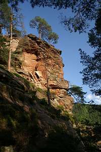
 Kumbtfels Kumbtfels |
Glastal Valley, to the north-west of the village of Erfweiler in the Wasgau Region is famous for its many climbing crags, all located very close to each other. While the mouth of the Valley, which opens directly onto Erfweiler, is dominated by the Rappenwand Cliff and the eastern slopes are home to the twin towers of Glasfelsen right at the end of the valley you find two cliffs, looming above the forest on the valley floor. The western one of these, Kumbtfels is arguably the most popular climbing crag in the valley with it Kumbtverschneidung Route on its east face which has spawned about 10 variations. The eastern cliff, called Winterbergfelsen is as impressive, though it lacks the popularity of its eastern neighbour. Further west - but still in the immediate vicinity - there are the Lobelia and Western Kumbtfels crags, the former also is a polular climbing destination, though mostly hidden in the forest.
Both the crags have a slab-like base, cut through by deep cracks. The summit block, however, in both cases is a very structured piece of rock, which tops out on a kind of platform. Both summits can be more or easily reached by a scramble up the slopes on the western sides and a few easy moves will get you to the platforms. From up there you can see all the other crags of the valley while in the distance the castles of Altendahn can be seen.
One last remark: over the last years the peregrine falcon population in the area has been on the rebound. Glastal Valley seems to be particularly popular among the birds so that each spring you can find at least one breeding pair on one of the cliffs. This in turn means that the cliff is closed to climbing and moreover sometimes even the paths beneath the crags are closed. Sometimes these measures seem to work though - apart from climbers - a lot of hikers and bikers also frequent the area. A popular hiking and biking trail, which connects Dahn, Erfweiler and Hauenstein runs right beneath the cliffs and will be rather crowded on any fine weekend.
|


Climbing Routes on Kumbtfels
 Kumbtfels west face
Kumbtfels and its neighbours are popular among climbers, especially the Kumbtverschneidung Route with its variations. Rather than reprinting the copyrighted information from the site of the Vereinigung Pfälzer Kletterer I link to their routes database directly with some summary info. Here is the link to the complete database.
| Feature | Routes link | Summary |
| Lobelia | Lobelia | 7 routes with variations ranging from 2+ - 5+ |
| Western Kumbtfels, Base | Western Kumbtfels, Base | 6 routes ranging 3+ - 7+ |
| Western Kumbtfels, Summit Block | Western Kumbtfels, Summit Block | 3 routes with variations ranging from 2 - 7+ |
| Kumbtfels | Kumbtfels | 12 routes with many variations ranging from 2 - 7 |
| Winterbergturm | Winterbergfelsen - Winterbergturm | 6 routes with variations ranging from 3 - 5 |
| Winterbergfelsen - Main Massif | Winterbergfelsen - Main Massif | 8 routes with variations ranging from 3+ - 5- |
| Winterbergfelsen - Eastern Massif | Winterbergfelsen - Eastern Massif | 1 route 5- |
Getting There
Kumbtfels is located north of Erfweiler, a 20 minute hike from the last parking lot at the end of the village. Erfweiler itself is hidden very deep inside Pfälzerwald and thus the itineraries are a bit longish. The closest airports are at Frankfurt and Stuttgart so the itineraries start there too.From Frankfurt
There are two possible routes which both take equally long- Via Ludwigshafen
- From Frankfurt take motorway A5 southward to Darmstadt.
- There change to A67 south.
- At Viernheimer Dreieck turn onto A6 west. Leav
- e it at Frankenthaler Kreuz for A61 south.
- At Mutterstädter Kreuz take A65 south until you reach Landau.
- At Landau turn on B10 west.
- At Hinterweidental turn onto B427 south which will take you to Dahn.
- In Dahn, after you have driven around Jungfernsprung there is an intersection directly in the town centre. Turn off left onto K39 which takes you to Erfweiler.
- In Erfweiler don't follow the main road (K39) where it bends right but rather go straight on (but later keep to the right) until the road ends in a parking lot
- From the parking lot follow the left hand trail, signed "Glastal" which takes you to the base of the cliff.
- Via Kaiserslautern
- From Frankfurt take motorway A3 west
- At Mönchhofdreieck turn onto A67 south
- At Rüsselsheimer Dreieck take A60 west
- At Kreuz Mainz Süd take A63 south
- At Kreuz Kaiserslautern turn onto A6 west
- At Kreuz Landstuhl turn onto A62 south
- At Pirmasens turn onto B10 east
- At Hinterweidental take B427 south to Dahn
- In Dahn turn onto K39 to Erfweiler
- In Erfweiler go straight on to the parking lot at the end of the village
From Stuttgart
- Take motorway A8 to Karlsruhe
- At Karlsruher Dreieck turn north onto A5
- Tke the next exit to head for A65
- At Kandel you can leave onto B427 which will lead you directly to Dahn where you can turn right onto K39 to Erfweiler. However the detour to Landau and B10 (see above) will take less time as the roads are better (three or four lanes)
|


Red Tape
 Lizard on top of Kumbtfels
Yes, there is red tape and lots of it. The sandstone of Südpfalz forms lots of caves and overhangs. Though this makes it most interesting for climbers, two species of birds of prey compete for this habitat: the peregrine falcons and the eagle owls. Both are endangered and wherever there is a eagle owl pair found nesting in the sandstone the crag will immediately be closed. Generally this closure lasts from the beginning of each year through Aug. 1st. If breeding is not successful the closures will be cancelled even before that date. For a list of closures see the Closure List of PK. However, if you find "Stop" signs on the access routes to the crags, please don't go there! Peregrines seem to be on the rebound from what I can tell and that's definitely good news1
The use of magnesia is not allowed in the whole Südpfalz region. This is rather a directive or an arrangement than an outright law. Thus you probably will get away with using it but do so only when absolutely necessary. Magnesia closes the pores which you find in the sandstone and together they form a smooth surface which will get very slippery in wet conditions. The rule of thumb is to use magnesia in the highest difficulty sections and only extremely sparingly.
A list of guidelines can be found here (in German).
Accommodation
You can find hotels and apartments in Erfweiler and in neighbouring Dahn. Have a look at the following links:There are two campgrounds, one in Dahn at Neudahner Weiher one in nearby Bruchweiler-Bärenbach.
Weather Conditions
  |
The closest available weather information is the one for Pirmasens (20km to the north-west):
Pirmasens weather
Maps & Books
Maps
As for maps there is a good overview map (1:50000) by Kompass Verlag but the best ones are the official topographic maps by the state government of Rheinland Pfalz, scaled 1:50000, 1:25000 and 1:5000. All official maps can be found on the web page of Landesvermessungsamt Rheinland Pfalz
1:50000
- Naturpark Pfälzer Wald
Kompass Map WK766
ISBN: 3-85491-523-3
- Pirmasens Süd
LVA RLP Map L6910
ISBN: 3-89637-193-2
1:25000
Books
Here are a number of climbing guidebooks on the region of Südpfalz. The best ones, however, have been published privately and are sold only in selected bookshops of the region.
- Hiking
- Pfälzerwald
B. & J.-Th. Titz
Rother Verlag
ISBN: 3-7633-4268-0 - Klettern im Buntsandstein
U. Daigger, H.-J. Cron
Published privately and out of print
- Pfalz ++, Klettern im Buntsandstein
R. Burkard, P. Weinrich
Published privately
- Klettern im Naturpark Pfälzerwald
Naturfreunde Lambrecht
Published privately - Pfalz & Nordvogesen en bloc
A. Wenner, Y. Corby, I. Bald
Panico Verlag
ISBN: 3-936740-19-4
Climbing