

|
|
Canyon |
|---|---|
|
|
38.28482°N / 110.40951°W |
|
|
Canyoneering |
|
|
Spring, Fall, Winter |
|
|
Overview
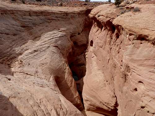 The Start of Larry Canyon
Larry Canyon is a Technical Slot Canyon located in Robbers Roost, Utah. Robbers Roost is a vast area of BLM Land that borders the Horseshoe Canyon Unit and the Maze District of Canyonlands National Park. In this area, hundreds of slot canyons can be found with varying ranges of technical difficulty. The access to these canyons are what make them so popular. Most of the canyons enable you to do a shuttle, which saves lots of hiking time. This is the case for Larry Canyon.
Larry Canyon is broken up into Upper and Lower. The Upper section is the more technical section and is what this page is focused on. There are only four rappels in this canyon, however, there are 5-6 down-climbs that could be rappelled and have been rappelled before due to the fact that webbing is in place around choke stones. So the amount of rappelling depends upon your down-climbing ability.
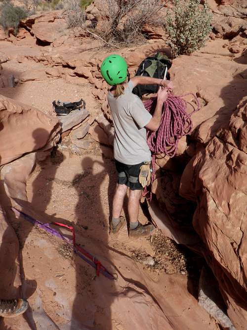
What to bring:60 meter rope, webbing (5ft sections and 10ft sections in-case webbing is gone or needs replacement) and rappelling gear. This canyon is rated 3A III (click HERE for information about the rating). A headlamp would be useful in the dark sections. Water might be present at the bottom of the second rappel, so dry bags might also be useful.
Route Beta
Follow the "Getting There" section to reach the parking for the upper entry point. Follow the wash that you chose until you reach the top of a canyon with sheer walls- you are at the top of Larry's Canyon. You have a few options here, you could either rappel off a smaller juniper to the left (it had a few pieces of webbing on it when we were there) or you could down-climb (recommended). Follow the canyon rim maybe ten feet to the left until you see some Moki Steps. Taking packs off might be a good idea for the first part. Then, slowly make your way down the face to the Moki Steps into the canyon. You are now in the Larry Canyon proper. The fun begins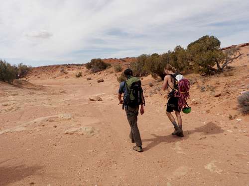 Hiking the wash
 Juniper with webbing
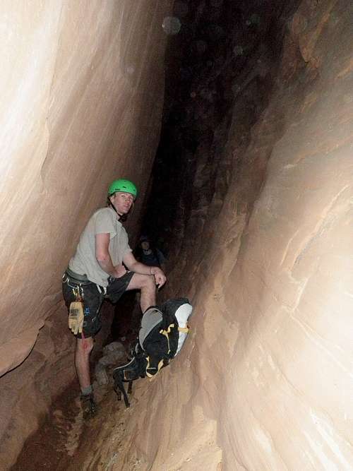
In the section between the entry point and the first rappel, there are four or more down-climbs. There are also some pretty tight sections. All of the down-climbs that we encountered when we were here had webbing in place so if you wanted to, you could rope up
 Greg and Kory Stemming to Avoid the Water Greg and Kory Stemming to Avoid the Water |  Kory Downclimbing a tough section before Rappel 1 Kory Downclimbing a tough section before Rappel 1 |
Rappel 1 comes .60 miles into the canyon. Because the going is slow in the first section, this .60 miles seems like 2 miles. Rappel 1 has a somewhat tricky down-climb to get to an overhanging chokestone with webbing and rappide links. This rappel is just under 80ft (24m) in a twirled slot.
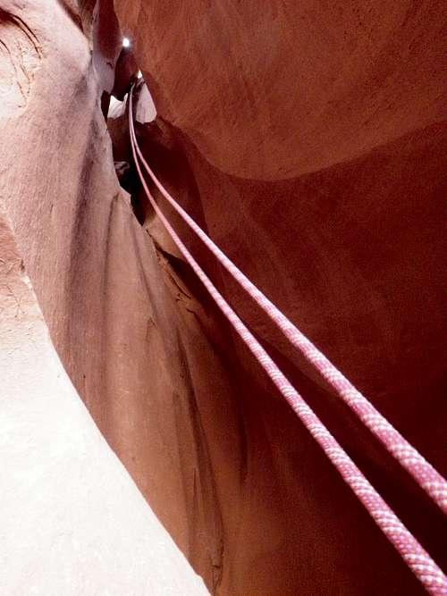 Looking up to the chokestone with webbing on Rappel 1 Looking up to the chokestone with webbing on Rappel 1 | 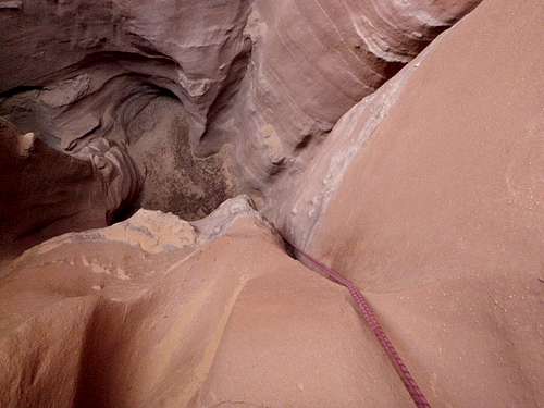 Looking Down Rappel 1 Looking Down Rappel 1 |
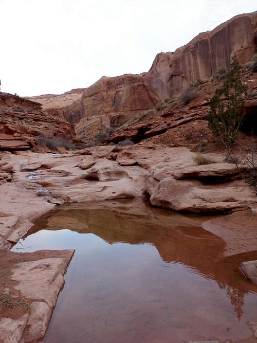
Rappel 2 comes just after rappel 1. Look for a large chokestone overhang almost out of reach. This has webbing and rappide links. This is a two stage rappel! We ran into trouble here because we didn't realize this. The first rappel is just over 50ft (16m) in another twirled slot. When you get to the bottom, stay on rappel and walk down the canyon (or wait for your party to get down, but don't pull the ropes!!. The second part of this rappel is over a chokestone (there are really no natural anchors in this part thats why its important to us the anchor from the first part of the rappel. From what I have heard, there is usually water at the bottom and there was for us and its deep! This rappel is 30ft (9m). If there is water at the bottom, you can choose to get wet or you can stem while on rappel to the dry side, which makes it more exciting. Together with the two stages of this rappel, it is 80ft (25m).
 Chokestone w/webbing Chokestone w/webbing | 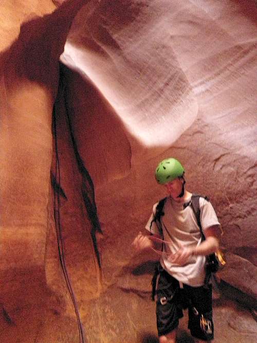 Greg at the bottom of the first part of Rappel 2 Greg at the bottom of the first part of Rappel 2 |
 Greg scouting out the 2nd part of Rappel 2 Greg scouting out the 2nd part of Rappel 2 |  Kory on the 2nd part of Rappel 2 Kory on the 2nd part of Rappel 2 |
The canyon opens briefly and then continues to get narrower after this rappel. There is very very tight section with lots of chokestone above. Do not go above to the chokestones! Stay below and squeeze through the slot. More downclimbing ensues until you reach a very dark section of the canyon. There is a maybe 10ft piece of webbing attached to a chokestone that you downclimb into a very very dark section of the slot. A headlamp is very usefull here. The canyon then tilts to the left and remains very tight and dark. This keeps up for .3 miles! You will be very tired by the end, but the slot does open up briefly a few times to allow you to stretch your left side.
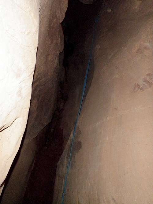 The fixed piece of webbing that signifies the dark slanted part of the canyon The fixed piece of webbing that signifies the dark slanted part of the canyon |  Alex in the dark section of the canyon Alex in the dark section of the canyon |
 Greg and Kory in the darkness of Larry Canyon Greg and Kory in the darkness of Larry Canyon |  Yes you came out of that..looking back at the dark tilted slot Yes you came out of that..looking back at the dark tilted slot |
Rappel 3 happens a few hundred feet after the dark slanted slot ends. The are bolts and hangers with webbing to the left. This rappel is 90ft (28m). Its also a little overhung with poor rock quality. Update As of May 29th 2012, there are no longer bolts at this rappel. Instead, there is a deadman anchor and webbing tied off to a small juniper both through a rapide -warzone.
 Greg setting up Rappel 3 Greg setting up Rappel 3 |  Greg on Rappel 3 Greg on Rappel 3 |
Rappel 4 comes right after this rappel. There is webbing and rap rings tied onto a a few large boulders. This rappel is 72ft (22m) tall. The technical aspect of Upper Larry Canyon is now over
 Rappel 4 from Rappel 3 Rappel 4 from Rappel 3 |  Looking back up at Rappel 4 Looking back up at Rappel 4 |
To get to the exit point, follow the canyon (more of a wash now) for 1.5 miles. The walls remain high on each side. While hiking the sandy wash, you will pass some slick rock sections with a seep. Close to the exit point, you will see a larger side canyon come in on the left. Keep going past this. Shortly after this, a low angle crack should appear on the cliffs on the left. When we were here, a trail was easily visible to the crack with cairns marking the turnoff and trail. If you continue below this, you go to Lower Larry's Canyon. If you miss this, there is a low angle cliff section maybe .25 miles down canyon that can provide you with an escape. From the first exit point, veer east over domes of cross bedded Navajo SS back to the road and back to the cars.
 Seep in Upper Larrys right before the first exit point
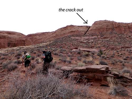 The first exit point. Pretty easy to spot
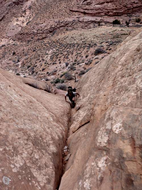 In the crack, easy climbing!
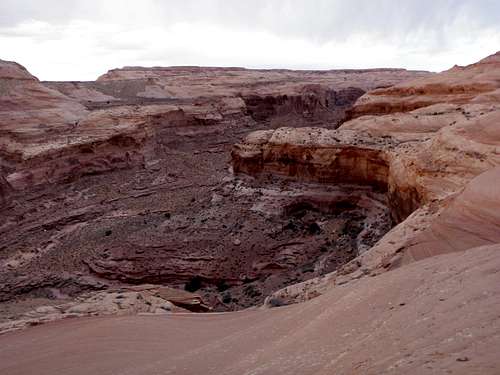 Looking back down at Larrys Canyon from the rim while hiking back to the cars
Red Tape/Access
There is no red tape here! Storms will make the roads muddier and may make some areas impassible.Camping
Camping is amazing all over this area. Since this area is all maintained by the BLM, camping is FREE! Good camping sites can be found in-between The Mailbox and Burr Pass, at Burr Pass, and along the road to get to the lower entry point of Larry Canyon (see Getting There for directions on how to get there). Camping is NOT limited to those areas, there are plenty of other good options around. For more information about BLM camping, click HERE.Getting There
From Hanksville, head east on HWY 24. In between milepost 135 and 136, take a right on the Lower San Rafael Road (or the "Maze Road"). You will be on dirt roads for a long time now most of which are in good shape unless otherwise noted. Follow this for 11 miles until you reach a sharp left turn. Follow this road east for 14.5 miles (don't veer off the many smaller dirt roads) until you reach the "Mailbox" (you are now 24.4 miles from HWY 24). From the Mailbox, take the right (south) fork and follow for just over 7 miles to Burr Pass (31.6 miles from HWY 24 now). Take the right fork once again and follow this for around 6.5 miles until you reach a sharp right at a ranch with outbuildings and no trespassing signs. Follow the road right for just under half a mile to a fork.The right fork leads to the upper car park and the left fork leads to the lower car park. To get to the upper car park, take a right and follow this road for .6 miles. This gets you to the first large pronounced wash. This is where we started, however, any little wash for the next half mile along the road will lead to the upper entry point for Larry Canyon. Find a pull out and park.
 Twin Corral Box Canyon from the wash
If shuttling, you will want to get to the lower car park. At the previously mentioned fork, take the left fork and follow this for 2.7 miles. When we were here, there were some bad wash out sections in this part of the road due to the fact that the road follows a wash. At 2.7 miles, the wash ends at the top of the North Fork of Twin Corral Box Canyon. The view here is not shabby at all!! The road then take a right up out of the wash (very rough section). About .30 miles later, this is a primitive camping spot with alot of Junipers. We pulled off here (and ended up camping here). However, if you wanted to cut down your walking even more, drive a full mile on on the road and find a pull. Park the car here and DONT FORGET THE KEYS TO YOUR SHUTTLE CAR!!
External Links
The MazeInformation about the Maze District of Canyonlands National Park and the Hans Flat Ranger Station (closest establishment in the area).
Current Weather Conditions
Current weather conditions for Larry's Canyon as forecasted by NOAA. DONT go into this canyon with rain in the forecast!!
Bureau of Land Managment (BLM)
Information about Utah's BLM Land
Technical Guide to the Canyons of the Colorado Plateau
The ultimate guide book for the technical canyon on the Colorado Plateau. Michael Kelsey is a master when it comes to directions and beta for canyoneering!
warzone - May 29, 2012 1:42 pm - Voted 10/10
Rappel 3There are no longer bolts by Rappel 3, there is a deadman anchor and webbing tied off to a small juniper both through a rapide
Alex Wood - Jun 2, 2012 9:13 pm - Hasn't voted
Re: Rappel 3Really? Wow, okay I will note that change on this page. Thanks for the heads up! Canyons are a dynamic place
Josh Lewis - Jul 10, 2012 1:01 am - Hasn't voted
SpidersThere was no mentioning of the hundreds if not thousands of spiders in the dark section. I kept my cool, but it kinda freaked me out. I know, kinda silly, but some people might not want to do this slot canyon because of this. Thank goodness they were daddy long leg spiders. Matt had them crawling all over him.
Alex Wood - Jul 18, 2012 8:58 pm - Hasn't voted
Re: Spidershaha there weren't any spiders when I was there, must be a seasonal type thing. When were you in Southern Utah?!?
Josh Lewis - Jul 18, 2012 9:17 pm - Hasn't voted
Re: SpidersLate June of 2012 with Matt Lemke. But the heat was too much for the both of us so we went back to Colorado.