
-
 3061 Hits
-
 80.49% Score
-
 12 Votes
|
|
Mountain/Rock |
|---|---|
|
|
47.32533°N / 11.44874°E |
|
|
Hiking |
|
|
Summer, Fall |
|
|
7677 ft / 2340 m |
|
|
Overview
 Lattenspitze (and Pfeiser Spitze)
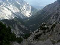
Together with the neighbouring Pfeiserspitze and Wildangerspitze, Lattenspitze is a rather unknown summit in the Inntal group of Karwendel range. This lonely summit stands high above Inntal to the south and Halltal to the north, thus dividing these two valleys.
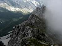
When tackled from Inntal you have to overcome about 1.600 m / 1.700 m of altitude difference to reach this summit. Steep rock and meadow slopes designate the summit and the east and west ridge, when viewed from Inntal valley ground. From Halltal or the northern Halltal summits, Lattenspitze has a much more spectacular appearance: a nearly perpendicular north face, composed of vertical limestone beds looking like huge staples of latches, which obviously gave this mountain its denomination.
The ascent and traverse of this summit is rather easy and worthwhile. You will meet few people, most locals, and you will have excellent looks to the south and into the southern parts of Halltal Karwendel. The full traverse with Wildangerspitze and Pfeiser Spitze is a great outing with a little Via Ferrata, some easy rock scramble and some airy parts on the ridges.
If you want to stay overnight at Pfeishütte, the nearest alpine club hut, the Lattenspitze traverse from Halltal or Inntal trailheads to this hut can be a more than satisfying start for an interesting stay in the region.
Getting There
 Lattenspitze
Main trailheads for Lattenspitze are
You reach Halltal
 Lattenspitze (center), framed by Haller Zunterkopf (left) and Hüttenkopf (right)
Halltal trailhead:
Halltal / Ißbrücke is the very last trailhead along the Halltal road.
Current regulations for Halltal (08 / 2014):
Halltal is closed to public traffic and will be so in the future. This is due to security regulations (landslide areas along the road).
Actually there is a shuttle bus service on weekends with good weather during the summer months (see schedule and prices here ).
This bus starts at Absam / Halltal parking area and ends at the Sankt Magdalena mountain inn. With this bus it is possible to reach all the Halltal trailheads without walking or at least with only a short additional walk.
During the week and in autumn a taxi service is available to the trailheads; prices actually (2014) range from 18 € to 23 € up to 5 persons and 25 € to 30 € up to 8 persons.
Thaur trailhead
Parking area at the end of Stollenstraße. Proceed uphill on that road until you reach the parking area on your left. You reach Thaur by using road number L 372 from Innsbruck or from Absam above Hall.
Pfeishütte
Pfeishütte is an alpine club hut located in the uppermost Gleirsch valley / Samertal valley. You reach Pfeishütte:
Routes Overview
 Lattenspitze
Halltal route
From Halltal / Ißbrücke trailhead follow the forest road in western direction to Herrenhäuser. Choose trail number 218 to Törl. Alternatively follow the forest road from Herrenhäuser to Issjöchl. Follow trail number 221 in the direction to Stempeljoch. After some 100 meters take the left hand trail at a trail junction and traverse the Wildangerspitze east slopes up to Törl.
At Törl follow the trail in western direction which zigzags up the east ridge of Wildangerspitze and Lattenspitze until you reach the summit.
Thaur route
From the Thaur trailhead follow the marked route up to Thaurer Alm which in its lower parts bypasses the forest road switchbacks and follows the forest road in its upper parts.
At the last switchback in front of Thaurer Alm leave the forest road to the right and follow the trail number 218 up to Törl, first traversing the steep south slopes of Lattenspitze then following the red-white-red marks off trail, ascending the meadow valley between Wildangerspitze and Kaisersäule, a tributary summit of Thaurer Zunterkopf with a monument (don´t follow the trail to Kaisersäule!).
At Törl, proceed as described for Halltal route.
 Halltal Halltal |  Törl as seen from Thaurer Alm Törl as seen from Thaurer Alm |  Ascent to Törl Ascent to Törl |
Route from Pfeishütte
From Pfeishütte follow trail number 221 up to Stempeljoch. Before reaching Stempeljoch choose the right hand trail, traversing the scree fields below Pfeiser Spitze and ascend the rock chute to the south ridge of Pfeiserspitze. Follow the marking on the ridge to Pfeiserspitze summit, ascend into another chute and leave the chute to the traverse of the south slopes between Pfeiser Spitze and Lattenspitze (short airy ridge crest passage and short via ferrata). Ascend to Lattenspitze summit.
 Halltal route Halltal route |  Halltal route Halltal route |  Halltal route and Thaurer Zunterkopf Halltal route and Thaurer Zunterkopf |
Wildangerspitze – Lattenspitze – Pfeiser Spitze traverse
The whole traverse is described here.
Red Tape & Accommodation
 Lattenspitze summit
Red Tape
Lattenspitze is part of the “Alpenpark Karwendel”, an important and strictly protected national park.
There is no entrance fee for the park but many regulations to follow.
There is a National Park Information Center at Hinterriß.
Accommodation
Camping is not allowed within Alpenpark Karwendel.
Food and lodging can be found in
Mountain huts
Gear & Mountain Condition
Lattenspitze is a hiking summit for late spring, summer and autumn, due to snow conditions in the early and late season. You need full hiking gear and, as the upper parts of the summit are very steep, no fear of vertigo.The traverse to Pfeiser Spitze and to Stempeljoch col is a bit more difficult, as there is a short Via Ferrata and some exposed and airy but easy rock scrambling involved. A helmet can be useful in these parts of the full traverse.
 Lattenspitze Lattenspitze |  Wildangerspitze Wildangerspitze |  Lattenspitze as seen from Halltal Lattenspitze as seen from Halltal |
Current Weather:
Maps & Guide Book
 Leading a happy life at Thaurer Alm
Maps
Alpenvereinskarte, 1 : 25.000, Karwendelgebirge, Mittleres Blatt, number 5/2, 2008
Alpenvereinskarte, 1 : 50.000, Innsbruck und Umgebung, number 31/5, 2nd edition, 1995
Guide Book
Walter Klier: Karwendel alpin, Alpenvereinsführer, Bergverlag Rother, München, 16th edition, 2011