
|
|
Route |
|---|---|
|
|
34.86640°N / 111.75147°W |
|
|
Hiking |
|
|
Spring, Summer, Fall, Winter |
|
|
Half a day |
|
|
Hike |
|
|
Overview
A network of trails runs along the outer edges of the city of Sedona. These trails are far enough from the city to provide the hiker with a wilderness experience.Huckaby is a 2.9 mile long trail that sits to the northeast of Sedona. It connects Midgley Bridge Trailhead on Route 89A to Schnebly Hill Road. Margs Draw Trail starts on Schnebly Hill Road on the east side of Sedona and heads south for 2 miles to end at Morgan Road.
To create longer day hikes, Margs Draw can be connected to Broken Arrow Trail to the south and Huckaby can be connected to Jim Thompson Trail to the north.
 Map |
Getting There
Midgley Bridge Trailhead on Route 89AThis area serves as trailhead to 4 different trails: Huckaby Trail, Jim Thompson Trail, Wilson Canyon Trail and South Wilson Mountain Trail. It is also a scenic viewpoint. The parking area can fill up fast on the weekends so get an early start. From the intersection of Routes 89A and 179 in Sedona (The “Y”), drive roughly 2 miles north on 89A to Midgley Bridge. The trailhead is immediately on the north side of the bridge on the left (west) side of the road.
Schnebly Hill Trailhead
Common to Huckaby and Margs Draw Trails. From the intersection of Routes 89A and 179 in Sedona (The “Y”), drive less than half a mile south on 179 to the first circle and turn left on Schnebly Hill Road. Drive 1 mile to trailhead.
Morgan Road Trailhead
Common to Margs Draw and Broken Arrow Trails. From the intersection of Routes 89A and 179 in Sedona (The “Y”), drive 1.4 miles south and turn left onto Morgan Road. Go a short distance to the end of the road.
Huckaby Trail
This description takes you from Midgley Bridge Trailhead to Schnebly Hill Rd Trailhead (2.9 miles)At the Midgley Bridge Trailhead, you will have great views of the bridge, Oak Creek Canyon, Wilson Canyon and Wilson Mountain.
 Midgley Bridge |  Oak Creek Canyon | 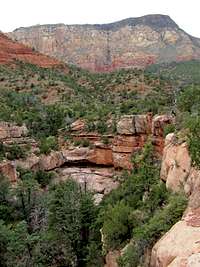 Wilson Mtn & Canyon |
The trail takes you under the bridge and then roughly 175 vertical feet down into Oak Creek Canyon.
 Descending into canyon |  Descending into canyon |
You will then have to cross to the east side of Oak Creek. There is no bridge but you can usually walk easily over the rocks in the creek.
 Oak Creek |  Oak Creek |
You can look back to see Midgley Bridge above you.
 Midgley Bridge |
The trail then heads south at the bottom of the canyon not far from the banks of Oak Creek.
 Along Oak Creek |  Along Oak Creek |
You will then begins to climb and go 200 vertical feet above the bottom of the canyon. You will have great views of Oak Creek Canyon and the city of Sedona with some of its famous red rock landmarks.
 Oak Creek |  Capitol Butte |
 Table Top Mtn | |
 Wilson Mtn | |
 Morning Glory Spire & Cibola Mitten | |
As you continue south, the walls of Munds Mountain and a rocky formation known as Snoopy Rock come to view. The trail goes down to the bottom of Bear Wallow Canyon and then comes back up to end at Schnebly Hill Road.
 Munds Mtn |  Snoopy Rock |
Margs Draw Trail
This description takes you from Schnebly Hill Road Trailhead to Morgan Road Trailhead (2 miles).The trail starts at the base of Snoopy Rock on the north side of it.
 Snoopy Rock |  Snoopy Rock |
It then heads south giving you good views of other rocky towers near Snoopy Rock.
 Snoopy Rock |  Near Snoopy Rock |  Near Snoopy Rock |
Munds Mountain will be in full view to the east.
 Munds Mountain |
After 0.9 miles, you will reach the junction of a 0.4 mile long spur trail on the right (west) that takes you to Sombart Lane Trailhead. Continue straight (south). You will get into a valley known as Margs Draw. A dry waterfall comes to view.
 Dry Waterfall |
As you continue south, you will have great views of the Twin Buttes, Munds Mountain, Capitol Butte, Wilson Mountain, Snoopy Rock and many other landmarks. The trail ends at Morgan Road Trailhead.
 Capitol Butte | |
 Wilson Mtn |  Snoopy Rock |
 Munds Mountain | |
 Twin Buttes | |
Essential Gear
Hiking equipment.Weather
See the forecast for the town of Sedona, AZ.Red Tape
You will need a Red Rock Parking Pass. See the link below:http://www.redrockcountry.org/passes-and-permits/where-to-purchase.shtml
External Links
Huckaby TrailMargs Draw Trail.