Introduction
The decision to go to Ecuador was somewhat last minute. Back in May, I heard about this research internship in the coastal rainforest, and after some debating about whether it was a proper use of finances and worth quitting my summer job early for, I decided to go for it. Soon after getting accepted, I had bought my plane ticket to Quito and was ready to leave at the end of July. The internship would last for two months, but since my winter job would not start until early October, I had a couple of weeks free after the internship before I had to return to the USA. However, I quickly realized I would not be in Ecuador during the ideal climbing season. I had heard awesome things about the Ecuadorian volcanoes and wanted to spend my last few weeks in Ecuador climbing them, but I figured the weather would not allow this and I would have to settle for hiking/trekking instead.
*Side note: I won't be discussing my internship here, since it has nothing to do with mountains or mountaineering! But if you would like to know more about it, let me know!
Fast forward to July 30st, 2012. I arrived in Quito safe and sound, looking forward to the adventure that lie ahead. For our first day in the country, a few other interns and I played tourist around Quito - we went sightseeing in the historical district, ate some delicious (and cheap!) Ecuadorian food, and went up the Teleferico. The Teleferico (a.k.a. gondola) takes you up to 3,945 m on Volcán Pichincha's east slopes, where you can get a taste of the high alpine páramo that overlooks the vast city of Quito without having to spend any energy hiking or climbing. The sights up there were quite spectacular, despite the somewhat touristy atmosphere and cloudy skies. A few locals informed us that if it was a clear day, we would be able to see more than 14 volcanoes from this point. This further spurred my desire to climb them, however, at that point in time I figured it was a pipe dream.
During the next two months, I didn't have the time or resources to do that much research on the Andes. However, I did find out that Cotopaxi, the tallest active volcano in the world (and second tallest in Ecuador), is generally climbable year-round. I learned that it usually has better weather than other parts of the Andes, and since it isn't that technical of a climb, poor weather wouldn't necessarily be a show-stopper. This sparked my interest, and I decided that if I could find a good guide for a reasonable price, I would try and climb Cotopaxi after my internship was over.
I knew that I had the skills to climb Cotopaxi without a guide if I wanted to, however, since I was a solo female traveler, didn't know the route, and had a high chance of encountering bad weather, I figured it would be best to hire a guide. I really wanted to climb Chimborazo as well, since it would be more challenging and it would be my new elevation record, not to mention it is the tallest mountain in Ecuador and the furthest point from the center of the Earth! However, I never thought Chimborazo would be a possibility due to the weather and dangerous route conditions this time of year. I also realized I would have to climb a few "smaller" mountains prior to Cotopaxi in order to acclimatize, since I was spending two months near the coast at a very low altitude.
Fast forward to September 24, 2012. After the internship was over, I headed back to Quito. I was pretty sad to be leaving the coastal rainforest and the friends I had made during the past two months, but the mountaineer in me was anxious to get climbing! I was also looking forward to spending time in the páramo ecosystem and experiencing the indigenous culture of the Andes. Even though I had stayed in relatively good shape during my internship, I was not acclimatized whatsoever. I figured that any excess red blood cells I was carrying from living in Colorado prior to this trip had disappeared, and I would need to spend some time prior to Cotopaxi acclimatizing on smaller mountains.
Being back in Quito was pretty overwhelming. Too many cars, buses, people, noises, and too much concrete, pavement, exhaust, and chaos. So, I was pretty eager to leave the city as soon as possible and get climbing. A friend at the hostel I had stayed at back in July had recommended this company called Gulliver, and I went to them first to inquire about a guide for Cotopaxi, as well as general information about where to acclimatize beforehand and current route conditions on the various volcanoes. They seemed like a trustworthy and reputable company, and their guide prices were within the range I was willing to pay. With their help, I came up with a tenative schedule for the next 5 days that included climbs of Pasochoa, Illiniza Norte, and Cotopaxi. At the time, they mentioned that conditions on Chimborazo were too dangerous...the reasons being avalanche danger, rockfall danger, large penitentes, smoke and ash from nearby Volcán Tungurahua, etc. (not sure if all of these were a factor at the time, or if they were just trying to scare me away from the mountain!).
Initially I planned on climbing Pasochoa and Illiniza Norte on my own to acclimatize, then using a guide for Cotopaxi. However, as I did more research, I realized the logistics of getting to and climbing these volcanoes was more complicated than I thought. Maybe if I hadn't been solo, and if I was fluent in Spanish, I would've been more motivated to attempt them without a guide. But instead I decided to team up with two women from Finland and their guide for Pasochoa, figuring it would be safer and more fun as a group. It turned out to be a good decision!
Pasochoa (4200 m): September 26, 2012
We left our hostel around 8:30am and drove about one hour to the "trailhead" of Pasochoa. There isn't an actual trailhead for this volcano though, let alone an actual trail until you get to the upper part of the mountain. However, I realize there are a few different ways to climb this volcano, so maybe things are different on the other routes. Anyways, after we left the Pan-American Highway, we followed a few signs towards Pasochoa and wound our way up past various farms higher towards the volcano.
The road was in okay condition at first, but it slowly deteriorated until we were on a windy and bumpy cobblestone road that made us all carsick until we finally pulled over in front of a woman's house. Apparently we were how entering private property, and each of us had to pay $5. Somehow our guide failed to mention this before we left. Oh well. After paying her and chatting for a bit, we drove on past her farm and continued up the road, eventually stopping near the hydroelectric plant. We started our hike from here, even though we could've easily kept driving up the cobblestone road. That was okay though, since this was going to be a short hike anyway, and a little extra elevation gain would probably be good for us.
Initially the hike up the road was lined with pine trees (which are not native by the way), and it wasn't until we got higher up that we started getting views of the surrounding countryside and the city of Quito off in the distance. Eventually the summit came into view, and we left the road and went on a very faint trail that paralleled a fence for a ways. This did not seem like the standard route at all though, since the grassy terrain we were on had not been travelled much, and there were times when we couldn't even see a trail. But it was still gorgeous countryside nonetheless, and I was very much enjoying myself - It was such a good feeling to be back in an alpine environment after being in the rainforest for two months! Eventually we hiked up towards a ridge where we met up with a well-traveled trail, and followed this around the base of Pasochoa. We passed an older woman who was collecting berries that were to be used in a festival in November celebrating the dead - she was very friendly, and told us to take a picture of her from the summit (we looked for her when we were up there, but unfortunately she was too far away).
As we got higher we saw lots of polylepis ("paper") trees, as well as other unique high alpine plants that in some ways resembled a few species in Colorado, such as lupine. We skirted below a few large rock outcroppings near the caldera rim, and eventually entered steeper terrain where we hiked up to the summit. The first views we got of the caldera were spectacular - an entire forest was growing in the middle of it surrounded by steep cliff faces, and we even saw two condors flying around inside of the caldera above the trees! We had pretty good views in all directions, despite some low-hanging clouds - at one point, we caught our first glimpses of the glaciers on Cotopaxi, but the summit would stay hidden from view.
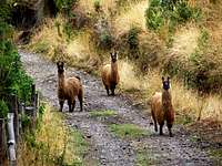
We hung out on the summit for probably 45 minutes, during which clouds started forming around us and it got significantly cooler. A couple of other tourists joined us up there, and we swapped stories about our respective experiences in Ecuador thus far. Initially we hiked down the same way we came, but instead of doing on the faint "trail" again past the lady collecting berries and the fence, we stayed on the main trail and eventually met back up with the cobblestone road. As we followed the road back down to the car, we came upon some llamas, which only desired to stare blankly at us as we walked past. We arrived back at the car around 2:30pm (for a total hiking time of around 4 hours), just before a thunderstorm moved in and it started to rain.
* Side note: I would come to learn that afternoon thunderstorms were a common theme this time of year in the Andes, and in order to successfully summit a mountain you would need to plan on summiting early in the morning (similar to climbing mountains in Colorado during the summer, for example). Luckily I managed to stick to this rule for my remaining climbs.
Pasochoa turned out to be a good warm-up for the remaining climbs I would do, and it definitely exceeded my expectations in terms of scenery. Our guide, Jaime, was great, and it was fun to hike with the two girls from Finland, Mia and Taina. However, when I returned to my hostel that afternoon, I learned that there was a scheduling conflict with my guide for Cotopaxi, and that I wouldn't be able to climb it when I was initially supposed to. Apparently, there was a big party on the coast for all of the ASEGUIM certified mountain guides, and the day of this party just so happened to be during the weekend I wanted to climb Cotopaxi. So, I could either climb Cotopaxi a few days after that, or climb it before the weekend...as in the day after Pasochoa.
After debating with myself for quite some time, I decided to climb it earlier rather than later. Boring details aside, it just worked better with my schedule for my remaining time in Ecuador, and I thought I had the physical and mental strength necessary to climb it despite not acclimatizing much beforehand. I had also handled high altitudes very well in the past - I had been above the elevation of Cotopaxi on two different climbs in Nepal, and had lived and climbed at high elevations in the United States for most of my life. In all my experiences, I had never had any symptoms of altitude sickness, yet I recognized what they were, and knew I was smart enough and humble enough to turn around if something did happen while I was on Cotopaxi. So, I decided to give it a shot.
Cotopaxi (5897 m): September 27-28, 2012
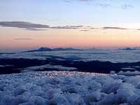
![Sangay, El Altar, and Tungurahua from Cotopaxi s summit]()
![Chimborazo from Cotopaxi s summit]()
![Cotopaxi s crater]()
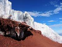
![the edge of the glacier]()
![Night before the climb]()
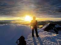
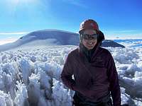
![Jose on Cotopaxi s summit]()
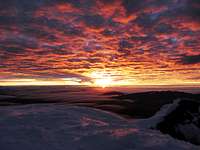
![Sunset on Antisana]()
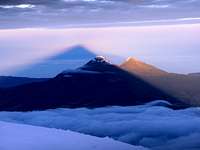
![Cotopaxi s shadow over Illinizas Norte and Sur]()
![William and Jose on Cotopaxi s summit]()
![William and Cotopaxi s shadow]()
![Refugio Jose Ribas]()
![Sunset from the refugio]()
![Refugio Jose Ribas]()
![Sunset on Cotopaxi]()
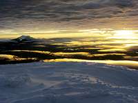
![Lights of Quito from Cotopaxi]()
![Sunrise on Cotopaxi]()
![Sunrise on Cotopaxi]()
![Me on the summit of Cotopaxi]()
![Sunrise on Cotopaxi]()
![Sunrise on Cotopaxi]()
![Giant serac on Cotopaxi]()
![Cotopaxi]()
![Cotopaxi]()
![heading down Cotopaxi]()
I tried to force myself to sleep in the morning of the 27th, since I knew I wouldn't get that much sleep up at the refugio prior to our climb. I met my guide, William, around noon, and he helped me get all of the necessary equipment that I would need for Cotopaxi. Since my main purpose for coming to Ecuador was the internship, I didn't bring any of my mountaineering gear with me from the states, plus I had to keep the one backpack I had under 50 lbs. So, I ended up renting most of my gear, which totaled to about $5/day. Have I mentioned yet how amazingly cheap things are in Ecuador compared to the United States (and how awesome this is for tourists like me)? I rented the following items: ice axe, crampons, helmet, harness, gloves, hat, gaiters, fleece pants, and mountaineering boots. Things I also needed (but already had with me) were: a sleeping bag, large backpack, headlamp, waterproof pants & jacket, sunglasses, sunscreen, water bottle, camera, etc. Although most of the gear I rented was pretty old-fashioned and had definitely seen heavy use, it all appeared to be in good condition.
After we stopped and bought food for the climb at a convenient store, we drove into the main entrance of Cotopaxi National Park and stopped at the entrance station. The turn-off to the park is about two hours south of Quito on the Pan American Highway, and then the entrance station is 15 km further down a dirt road. Here, my guide checked us in (there is no longer an entrance fee for anyone entering the park, although it is $20/night to stay at the refugio), and then we drove about 20 km further to the main parking lot below the refugio. I actually wasn't that impressed with what I saw of the park from the car window - a lot of it seemed to resemble the surface of Mars, and the only trees I saw were pine trees that had been strategically planted all at the same time. There was lots of construction going on within the park...at one point we had to stop and wait for 20 minutes while a truck filled a ditch with dirt so that we could drive past. We also didn't have any views of Cotopaxi as we drove through the park because of the cloudy weather. To make things worse, it started to rain as we got closer to the parking lot, and right as we pulled up it started to hail.
We stayed in the car for half an hour waiting for the hail to stop. During this time, I was having serious doubts as to whether this would work out or not. I started to get mad at myself for wasting time and money on this climb when I knew there would be bad weather. I imagined us starting our climb that night in a blizzard and turning around 10 minutes after leaving the refugio. But, I tried to stay positive, and I reminded myself that the weather could be completely different in 12 hours. It was the afternoon anyway, and the weather was usually better in the mornings. William (my guide) and I spent that time in the car talking about what mountains we had climbed and wanted to climb in the future, and I interrogated him about his experiences on other volcanoes throughout Ecuador. It was a great way to practice my Spanish!
After the hail stopped, we got our packs together and made the 45 minute hike up to El Refugio José Ribas at 4810 m. During this time the weather improved significantly, and we were rewarded with occasional glimpses of the upper mountain. I definitely felt the altitude on the way up to the refugio...it was as if my lungs were suddenly half their size, but required to do twice as much work. Luckily it was a pretty short hike, but it definitely got me thinking: Am I an idiot to be doing this without properly acclimatizing?
It was pretty cold up at the refugio. I went inside expecting a warm and cozy atmosphere, but soon realized it was the same temperature inside as it was outside. It was still a cool hut nonetheless, one with lots of history, and after I picked a bed and unpacked my stuff I felt very happy to be there. The refugio was much bigger than I was expecting - it is probably possible to sleep around 50 people in there. There are an endless number of bunk beds upstairs all pushed together, and the downstairs resembles a log cabin dining hall, similar to what you would find at a ski resort. When I was there, a study abroad group from Quito was planning on climbing the same time I was, so apparently the refugio was a little bit more crowded than usual for this time of year. Besides that group, there were climbers from France, Switzerland, Austria, the United States, Israel, and probably a few other countries as well. The only Ecuadorians were the guides, and in total, there were probably 30 of us up there that were planning on summiting the next morning.
I spent the rest of the afternoon/evening eating, hydrating, talking to the other climbers, and taking pictures of the amazing sunset. Although my cold fingers didn't like the experience, the sunset we saw from the refugio that night was one of the most amazing I had ever seen! Inside, I forced myself to drink lots of tea, knowing that the more hydrated I was the better I would handle the altitude during the climb. For dinner we had chicken, soup, and bread, which was a lot more delicious than it sounds. I ate with another solo female climber from Israel, and although she was fun to talk to, I was thinking in the back of my mind that she should not be up here attempting this climb. She was very inexperienced on glaciers and at altitude, not to mention she had no meat on her bones and was already freezing just sitting in the refugio with all of her layers on, and it would be a lot colder during the climb. I seriously doubted she would make it to the summit. However, as you will read, first impressions aren't always correct!
On the flip side, I also talked to two climbers from Switzerland, and at first our conversation was great - they told me all about the Alps, and also their experiences on Cayambe and Illinizas prior to this Cotopaxi climb. Then we started talking about me, and after I mentioned how little I had acclimatized, their facial expressions turned from friendly to angry and they started lecturing me on how irresponsible I was to be up here, and how I should've done more research on the negative effects of altitude. At first I attempted to explain how I did in fact know what I was doing, and yes, ideally I would've been able to acclimatize more, but that it just hadn't worked out with my schedule. They didn't seem to care though. So, despite my attempts to shrug those guys off, I went to bed at 7pm with even more doubts in my head about what I was about to attempt.
I spent the next 5 hours laying in my sleeping bag tossing and turning while I listened to other people snore. I knew that I wasn't able to sleep due to the altitude and the fact that I hadn't acclimatized, not to mention I hadn't slept in cold weather for awhile and I had a zillion thoughts bouncing around in my head about the upcoming climb. I maybe got 30 minutes total of sleep, but when my alarm went off at midnight I was relieved to finally get up and start the climb. When I went outside to use the bathroom, I was shocked by what I saw - a huge starry sky overhead, complete with a bright (and almost full) moon! Things were looking good. Some people had gotten up at 11 pm with plans to start around midnight, but William said we would be fine starting at 1 am, since he liked the pace I was able to go at during our short hike up to the refugio from the parking lot. So, after getting ready and eating a quick breakfast (tea, bread, and yogurt), William and I set out.
For the first hour or so we hiked up the "trail" to the base of the glacier, which was mostly loose volcanic dirt/rock. Since the moon was out, we didn't need to use our headlamps. William and I talked a lot at the beginning, although I soon realized that my Spanish skills were a lot worse when I was sleep-deprived, so we soon switched to silence. At the foot of the glacier we took a break, put on our crampons, and roped up. Here we caught up to one of the study abroad groups, and as I was putting on my gear, I heard one of the girls mention how she didn't know how to use an ice axe, or what to do if she fell. This was a little alarming, since I had assumed someone had already taught her the basics before this climb, but I guess not! So, I gave her and her friends a 2 minute lecture on how to use an ice axe, as their guide stood off to the side and twiddled his thumbs.
The route was in pretty good condition all the way to the summit, and more or less followed the same description as on the Cotopaxi Summitpost page. It was pretty surreal being on a glacier that was glowing in the dark under the moonlight, and having the lights of Quito illuminating in the distance. The route was pretty easy to follow, even though we occasionally encountered a few centimeters of fresh snow that covered up the old tracks. There were three short steep sections (around 60 degrees) where an extra ice tool would've been nice, but it wasn't necessary. We also had to step over two or three small crevasses, and at one point had to cross under a pretty large overhanging serac (this was more dangerous on the way down when the weather was warmer), but the rest of the route was pretty straightforward. One part of the route went through an amazing maze of crevasses, ice caves, and unique snow formations, and this was probably my favorite part of the whole climb. As it got closer to sunrise a few clouds moved in below us, but the sky above stayed clear, there was no wind, and the temperature was perfect for climbing.
As we got higher I could feel myself getting more and more tired...at one point I remember thinking that if I let myself, I could probably fall asleep standing up. But I pushed on, and despite our relatively late start, William and I somehow managed to pass all of the other groups on the way up to the summit. Maybe 15 people turned around for one reason or another, but the last group we passed heading up turned out to be the girl from Israel and her guide! I was very impressed to see her this far along. Since we were so close to the summit at this point, I knew she would make it, and I scolded myself for thinking she was incapable.
We reached the summit at 5:45am, 4 hours and 45 minutes after leaving the refugio. The views up there were amazing - by far one of the most spectacular summits I have ever stood upon. We could smell sulfur from the huge crater below, and even saw some fumaroles smoking on the opposite side. It was pretty cool to be on the summit before anyone else, too. We had to stand around for 10 minutes doing the penguin dance to keep warm before the sun came up, but once it did, everything around us turned pink and orange, and the shadow of Cotopaxi rose over the Illinizas to the west. Most of the major volcanoes in Ecuador were visible from this point, and I gazed in awe upon the beauty of Cayambe, Antisana, Tungurahua, Rumiñahui, Pichincha, Corazón, Pasochoa, Illinizas, El Altar, Sangay, and Chimborazo as they turned from pink to orange as well.
We hung out on the summit for about 30 minutes until the girl from Israel and her guide showed up. We chatted with them for a bit, and as we all soaked in the view her guide, José, casually mentioned that he wanted to climb Chimborazo the following week just for fun, since he hadn't been up it in awhile ("awhile" meaning a couple of months!). I told him that I had heard conditions on the mountain were pretty unsafe right now, but he just shrugged and said, "Well, my friend climbed it a couple of days ago and said it was fine...a few penitentes to deal with, but that's about it." Clearly, condition reports can be drastically different depending on who you talk to! So, I jumped on the opportunity and asked if I could come along with him. He agreed, and we made tentative plans for early the following week.
The climb down was significantly shorter than the climb up, but it seemed to go on forever! I quickly realized I hadn't brought enough food with me, which added to my already extremely tired state, and by this point the sun was out in full force, meaning the glacier we were on was now a solar oven. Despite these things though, it was awesome to see the route in the daylight, especially the giant crevasses and ice formations surrounding us! On the way down we passed many groups still making their way up, including the two climbers from Switzerland, who appeared to be struggling. Even though I wanted to say something sarcastic to them as we went past, I figured it best to simply smile and continue on. We got back down to the refugio at 8:20am, about two hours after leaving the summit. Although every muscle and nerve fiber in my body was telling me to crawl in my sleeping bag and go to sleep, we packed up our things and hiked back down to the parking lot. By this point the weather was turning again, and as we drove off Cotopaxi disappeared back into the clouds.
Back at the hostel I told Mia and Taina about my Cotopaxi climb, since they would be attempting it too in a few days. They were planning on climbing Illinizas Norte the next day with Jaime, and even though I was still extremely tired and sleep-deprived from Cotopaxi, I decided to join them. I figured that Illiniza Norte would be pretty easy after Cotopaxi, and plus, I was only in Ecuador once, and I would have lots of time to rest once I was back in the States.
Illiniza Norte (5126 m): September 29, 2012
We all left the hostel around 8:00 am, then stopped in the town of Chaupi to get food for our climb. Even though the weather in Chaupi was pretty good, there were clouds hanging low over all of the mountains nearby, and it seemed as if my good luck with weather was about to run out. From Chaupi it was only a little bit further to La Reserva Ecologica Los Illinizas and the La Virgen parking lot at 3900 m. We started hiking around 9 am. A guy from London named John joined us, and he would be an irreplaceable source of entertainment for the day.
The trail up to the Refugio Nuevos Horizontes (4700 m) was very well-traveled, and as long as you keep following the signs for "Refugio", it is hard to get lost. It took us about two and a half hours to hike up to the refugio, and we took a long lunch break inside. This refugio is strategically located in between Illiniza Norte and Sur, and if I had more time in Ecuador, I would've liked to spend a night at this refugio and climb both peaks. On the way up we had occasional views of Illiniza's lower slopes and the valley below, but as we got higher, the clouds socked us in and it got significantly colder. We saw lots of cool plants along the way though, and as we hung out inside the refugio a fox came by to visit - chances are he was used to getting fed by climbers on a regular basis.
The refugio was a lot smaller and cozier than the one I had stayed in on Cotopaxi. There was only one room with sleeping space for maybe 15 people (10$/night), as well as a communal kitchen that had some leftover food from past climbers. However, that day we were the only ones up there, and we would only see two other climbers the entire day. We ate a delicious lunch consisting of turkey/cheese/tomato sandwiches and tea, but we were pretty eager to get climbing, since it was freezing in the refugio. Plus, the weather just seemed to be getting worse and worse...the clouds were getting thicker, and the wind was picking up.
After we put on our harnesses and helmets, we headed up the standard route of Illinizas Norte. The route starts off by staying on the SE ridge direct until you reach the top of a false summit, then it traverses around the north side of the peak (this part is called "El Paso de la Muerte") and then climbs up a gully to the summit. The initial ridge was easy scrambling with minimal exposure, and at times the clouds parted just enough to give us some views. Luckily the wind didn't get any worse, and despite it being cloudy, it never rained or snowed. Unfortunately we were never able to see Illinizas Sur, but the views to the northeast were gorgeous nonetheless when the clouds did part. As we traversed around El Paso de la Muerte it became more exposed, but the rock remained pretty solid. Jaime set up a fixed line for one section as we traversed over to our ascent gully, and then another one going up the gully towards the summit. There were already bolts in the rock on these sections, since it is common for people to rope up here.
When we reached the upper gully we encountered some rhime on the rocks, and this made the last couple of moves to the summit a little challenging. Despite being socked in the clouds with no views, we were all estatic to reach the summit at 2:40 pm. John had previously tried to climb Illiniza Norte once before and failed, so this was particularly rewarding for him. We didn't stay on the summit long though since it was pretty cold and windy. Initially we headed down our ascent route, but instead of traversing back across El Paso de la Muerte to the ridge, we kept heading down the north face "skree route". This route is much easier to go down than up since the skree is so loose, although in my opinion people shouldn't go this way because it increases erosion. We skree-skied our way down to the creek (this route doesn't lead back to the refugio), then eventually met back up with the main trail. After that it was smooth sailing back to the parking lot, where we arrived at 5pm.
Just before we drove off the clouds parted enough for us to catch a glimpse of the summit, which was a nice reward for our efforts. All in all, Illiniza Norte was a fun climb, and I am definitely glad I chose to do it instead of taking a rest day after Cotopaxi. It was much easier than I expected since I was well-acclimatized by this point...it felt like I was climbing a mountain at sea level! The route itself reminded me of a lot of the class 3 and 4 routes on some of the 14ers in Colorado; very similar rock, exposure, and elevation gain. If I had been by myself or with more experienced climbers, I don't think it would've been necessary to rope up, but since Mia, Taina, and John were less familiar with scrambling and exposure, it was a good idea for our group to do so.
On the way back to the hostel, we caught some gorgeous glimpses of Cotopaxi and Rumiñahui as the sun was setting. By this point my legs were ready for a rest, and I was looking forward to a full night's sleep! I now had two free days before I would attempt Chimborazo with José. At first I was planning on visiting Quilotoa (a giant caldera lake), but I decided to go to a town called Mindo instead, since a few interns from my program were going to be there, and I felt like seeing some familiar faces. Plus, it would be fun to hike in the cloud forest again and see some cool birds (Mindo has the greatest number of endemic montane birds of any place in the world). The only downside would be spending two days at a pretty low altitude (1500 m), but I figured since it was only two days I would still be okay for Chimborazo.
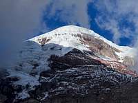
Chimborazo (6310 m): October 2 - 3, 2012
The itinerary for this climb was pretty similar to Cotopaxi, except that the climb was longer, the route was more challenging, and the summit was higher. After re-renting all of my climbing gear (the same gear I used on Cotopaxi), José and I drove south to Ambato, where we had lunch and bought food for the climb. Then we drove the northern route towards Chimborazo (the one that doesn't go through Riobamba), and entered La Reserva de Producción Faunistíca Chimborazo. There was no one at the entrance station though, so we just kept on driving up to the Refugio Carrel at 4800 m.
*Side note: there wouldn't have been an entrance fee anyways, but you do have to check in and pay $10/night to stay at the refugio.
The drive from Ambato towards Chimborazo was pretty amazing. We drove through a few small indigenous villages and caught a glimpse of how these people live...needless to say it was very different than in coastal Ecuador. Some of the homes were simple mud or straw huts, and everyone (men, women, children, and the elderly) farmed on the surrounding hillsides no matter how steep the terrain was. At one place people were gathering for what appeared to be some sort of rodeo, and it was pretty cool to see how much pride everyone takes in their indigenous dress - red, pink, and purple ponchos, bowler hats, etc. As much as I wanted to spend the entire day talking to these people and learning more about their culture, we had to continue on up to the mountain.
Along the way José and I had some good conversations in Spanish...it made me realize how much my Spanish had improved since being in Ecuador! We talked about the differences between Ecuador and the United States in terms of jobs/careers, education, politics (Correa vs. Obama), people's happiness, and even the differences between Ecuadorian and American men and how they act towards women. Needless to say, we both had vastly different opinions, stories, and perspectives! As we got closer to Chimborazo, the terrain completely changed and once again I felt like I was on the surface of Mars. The volcano rose in front of us to the impressive height of 6310 m, but not surprisingly the summit was hidden in the clouds so we could only see the lower glaciers. Nonetheless, I could feel this giant volcano's looming presence over everything around us, and for the first time in a very long time I was actually a little afraid and intimidated to climb the mountain. Maybe it was because it was taller than all the others? Or maybe because the route would be more challenging? Either way, it was sure to be an awesome adventure, and I welcomed the challenge.
We parked next to Refugio Carrel, got our packs together, and hiked 30 minutes up to the Whymper Refugio at 5000 m. There were some thunderstorms down in the valleys below us, but the clouds at our elevation didn't seem too threatening. Along the trail there were lots of memorials for past climbers who had died on Chimborazo...this was a little unsettling to see, and once again, I wondered if I was getting in over my head. There were lots of Vicuñas roaming around (a type of camelid related to llamas and alpacas) which was cool, and at times the clouds parted just enough for us to see the upper mountain. The view reminded me somewhat of Mt. Rainier, except the mountain was bigger, and the surrounding landscape was volcanic dirt/rock instead of temperate rainforest. The refugio itself was similar in size and layout to the one on Cotopaxi, however, this time it was mostly empty. There were two climbers from Germany already up there who were also planning on summiting the next morning, but no one else.
We spent the next couple of hours eating soup and bread, drinking tea, and talking. During this time a park ranger came into the refugio to check in with us, and he informed us of the new rules on Chimborazo in regards to having a guide. Apparently, three months ago there had been a bad accident involving a solo climber from Switzerland, and after that, a rule had been established that all climbers must now have a guide for Chimborazo (not sure how long this will last?). Since the two climbers from Germany did not have a guide, the ranger said they must climb with me and José since José was a certified guide. None of us were really happy about this, but we agreed anyway...turns out it wouldn't really matter, since the German climbers would go at their own pace regardless.
When we went to bed at 7 pm we were completely socked in the clouds, but like the Cotopaxi climb, I hoped we would wake up to clear skies in a few hours. Luckily it was much easier for me to sleep this time...I slept for a solid 4 hours before my alarm went off at 11 pm. Then it was time to put on gear, eat some food, and start the climb. We were pleased to see a starry sky above us as we started out, along with minimal wind. José and I left the refugio around 11:45 pm, and the two German climbers would leave about 30 minutes later. They apparently wanted to do their own thing and not climb with us, which was understandable...I just hoped they knew what they were doing!
We climbed the standard route via El Castillo, as described on Chimborazo's Summitpost page. We started off by hiking towards the mountain and angling left, passing some boulder mounds and walking through a large, flat field (on the way down I noticed an "H" here; probably where helicopters land if necessary). Then we started climbing northwest up through the rocky/icy terrain underneath El Castillo, eventually passing the Corridor and reaching the upper saddle on the ridge separating El Castillo from Chimborazo's summit. This part of the climb was definitely the most tedious (although not the most exhausting), since much care had to be taken not to slip. The lower section was all rock (boulders/talus/skree), but about halfway up to the ridge the Thielmann glacier started, which meant we were now climbing on rock-covered ice and hardpan. Higher up we encountered areas of fresh snow, which turned out to be a blessing in disguise since it was much more grippy. We had to take out our ice axes and crampons once we encountered ice, although most of the ice was still covered with rocks. I felt sorry for the torture my crampons had to endure as we climbed through that terrain, but at least they were rentals! We roped up for one short steep section before we got up to the ridge, but most of it we climbed un-roped.
We reached the saddle next to El Castillo about two and a half hours after leaving the refugio. Soon the two German climbers caught up to us and passed without comment. Thanks to the moonlight, we had a great view of the remaining route up to the summit, and surprisingly it didn't look too difficult. However, that assumption turned out to be wrong, since at that point I wasn't able to see the upper glacier where all of the penitentes were! We climbed up the ridge towards the summit, which at first was just dirt, skree, and boulders. Eventually we got on the glacier, roped up, and followed this glacier east up to the Veintimilla summit at 6267 m, which is one of Chimborazo's 4 sub-summits (the Whymper summit is the highest).
At first it was easy going on the glacier, but as it got steeper (up to 45 degrees), we encountered more and more penitentes. These had formed recently as a result of the ash that had drifted over from Volcán Tungurahua when it erupted a month or so ago. Because of the albedo affect, the ash had caused rapid melting on the upper glaciers of Chimborazo and subsequent penitente formation. At first I thought the penitentes were awesome - I had never seen ones this big before, and it was like we were climbing on another planet! My opinion soon changed though once I realized how difficult it would be to climb through such terrain.
Since very few people had climbed Chimborazo after the "ash incident", there was no established visible route up this glacier, so José and I had to find our own way through the crevasses and penitentes. The two German climbers ventured further south for some reason, which wasn't the standard way up the glacier, so we didn't follow their route. Nonetheless, the way went was still extremely exhausting...climbing up, around, and through the penitentes was much more difficult than any glacier climbing I had ever done. We had to use our ice axes to hack away the pentitentes as we climbed through them, and since the glacier was pretty much all ice, some of the terrain required front-pointing. We also encountered some pretty large crevasses that held us up at times...we would have to traverse far left or right to find a way around them, and sometimes the way we went wouldn't work, so we would have to go back the other way and around before continuing on.
Not only was it harder to breathe at this altitude, but climbing through the penitentes required the use of so many more muscles than I was used to climbing with, so needless to say I was pretty miserable and exhausted by this point in the climb. I also knew in the back of my mind that time was not on our side, since we had to get down past the Corridor before the sun heated up the lower part of the route too much and the risk for rockfall greatly increased.
It started to get light as we approached the Veintimilla summit, and luckily the terrain eased up a bit as we approached the top. Volcán Sangay was erupting to the southeast, which for me was an amazing thing to witness (José just said this volcano erupts all the time, and it wasn't that big of a deal. I disagree!). By this point it had gotten a lot colder and windier, so José and I were both happy when the sunlight first hit our faces. My water and Gatorade had almost completely frozen in my backpack, so I welcomed the warmer weather the sun would bring. We reached the top of Veintimilla at about 6am and took a much needed break. Our work was not finished though...we still had to descend off of Veintimilla, cross a large basin, and then climb up to the Whymper summit - the true summit of Chimborazo. As we rested on Veintimilla the two German climbers were making their way up to Whymper, and based on their slow progress, it would not be a walk in the park. Luckily the penitentes up here were much smaller than those we had previously encountered, so it wouldn't be quite the sufferfest.
We reached the Whymper summit about 45 minutes after leaving Veintimilla, and about 7 hours after leaving the refugio. It had been the longest 7 hours of my entire life, but when I reached the actual summit of Chimborazo I was flooded with so many rewarding emotions that it was suddenly all worth it. I couldn't believe I was actually there - at 6310 m above sea level, my new elevation record, and standing on the point furthest from the center of the earth (due to the equatorial bulge (or "muffintop" as I like to call it) Chimborazo's summit is further from the center of the earth than Everest's summit). The views we had were equally amazing to those on Cotopaxi - we could see lots of the surrounding volcanoes rising above the clouds, and it was pretty cool to look over at Pasochoa, Illiniza Norte, and Cotopaxi knowing that I had already climbed them. We even caught glimpses of the ocean to the west, and I remember thinking that there are probably very few places on earth where you can stand and look down from 6310 m to sea level (except in a plane, of course!).
We didn't hang out for too long, since the sun was already getting higher in the sky, and we were concerned about rockfall in the Corridor. The climb back up to Veintimilla was reminiscent of the suffering we had already endured, and then we descended our ascent route down the glacier to the saddle next to El Castillo. The descent was much easier since we could now see the terrain around us and our lungs weren't working overtime anymore. Despite this though, my legs still felt like rubber and I was mentally exhausted, so I had to focus extra hard on every step I took and every place of the ice axe. By this point the German climbers were way below us, and they would get back down to the refugio, pack up, and leave before we even got back.
The descent from the saddle back to the large flat rock field was possibly the worst part of the entire day...it was a sufferfest different than the one we had endured going through the penitentes, but this time we were also worried about rocks crashing down on us from El Castillo. For this reason we didn't rope up for most of it. It was sunny and hot by this point, which further zapped any energy I had scrounged up in my already energy-deprived muscles. Descending down the rock-covered ice was even more tedious than the ascent, since there was now meltwater running over much of the ice in small streams. Plus, even though we could now see the route in the daylight, it was hard to find the "easiest" way down, let alone our ascent route, and looking back I am pretty sure we descended a much more technical way than necessary. On a few sections we were forced to downclimb a few pitches of ice that were maybe 60 degrees, and this was extremely challenging without having two ice tools.
We tried to pick up our speed as we crossed under El Castillo and through the Corridor, but by that point I was so exhausted that I physically couldn't go much faster without slipping or tripping. It was a huge relief to finally take off our crampons, and luckily we made it back down to the flat field safe and sound. We actually didn't witness ANY rockfall during our entire descent, which was very surprising. After hiking back across the flat field, we arrived at the refugio at 11 am, making for an almost 12-hour day. By this point clouds were forming again, and as we ate "lunch" inside the refugio, the mountain disappeared behind them, and I would not see Chimborazo again.
We packed up our things and hiked back down to the lower refugio. There were a few groups of casual dayhikers who were up there to visit the refugios and catch a glimpse of the mountain, and we got a few puzzling looks as we hiked past with giant backpacks and climbing gear. José drove us back to Ambato, where I got out and caught a bus to Baños, my next destination. I would then spend two days in Baños biking, hiking, and seeing the sights, then travel to Riobamba for a day to see the local indigenous market that goes on every Saturday (highly recommended if you go - way less touristy than the market in Otavalo!). After that I returned to the United States, sad to be leaving such an amazing country, but happy I had experienced so many spectacular things in the 9 weeks I was there. Thanks for reading, and I hope this trip report is useful to people in the future! Feel free to contact me if you have any questions or would like more information.
- Sarah
Random Tips
- In Ecuador, you get what you pay for in terms of mountain guides. There are ones you can hire for an insanely cheap price, but they wouldn't necessarily be that knowledgeable, trustworthy, or certified. On the flip side, you can easily find a guide through an international organization that will charge an outrageous price (and probably include everything in a package for you: transporation, food, lodging, equipment, etc.). Bottom line is you want a guide that is certified (ASEGUIM/IFMGA), experienced, and has a good reputation. I highly recommend Jaime, William, and José (the three guides I had while in Ecuador) - they work with Gulliver part-time and do freelance on the side as well.
- Drink only boiled, bottled, or treated water. Don't drink from the tap in any of the towns/cities!
- Even though Ecuador uses the US dollar, you basically can't use any bills larger than $10, (unless you are paying for something over $10, of course). Most places don't have change for a $20, and you will get mean looks if you try to pay with one. So, when you get cash at an ATM and receive $20's (sometimes you get lucky and a few $10's pop out), you then have to go to a bank and exchange them for smaller bills/dollar coins.
- It seems like everyone is a bad driver in Ecuador, even the bus drivers and guides. People drive much more aggressively than in the States, and at first it can be a little scary, especially if you are on a windy mountain road (such as the one from Ambato to Chimborazo). But after awhile I found that I got used to it, and it made the trip more exciting!
- I think that I was very fortunate and/or lucky when I was in Ecuador because I did not get robbed, sick, or have any major issues with transportation. Pretty much everyone I talked to down there had experienced at least one of those. So, be careful with your belongings (especially on buses), don't drink from questionable water sources or eat questionable food (like street food), and give yourself extra time to get from A to B, since you never know when you might get delayed.
- Lastly, even though I didn't really do this, it is much better to properly acclimatize before climbs like Cotopaxi and Chimborazo!!! You will have a better chance at summiting, sleep better at night, feel better during the climbs, reduce your risk of brain damage, and avoid a potentially dangerous situation where you develop altitude sickness, HAPE, or HACE. Acclimatization is your friend!!!


Comments
Post a Comment