
-
 6066 Hits
-
 84.72% Score
-
 19 Votes
|
|
Mountain/Rock |
|---|---|
|
|
49.18351°N / 7.88863°E |
|
|
Scrambling |
|
|
Spring, Summer, Fall |
|
|
1017 ft / 310 m |
|
|
Overview
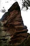
 Luger Friedrich above the village of Lug Luger Friedrich above the village of Lug |
The village of Lug in the Südpfalz Area of the German state of Rheinland Pfalz is located in a basin between the Pfälzerwald hills. Though two of the more important roads, which connect the towns of the area, intersect in the village, it nevertheless has remained comparatively tranquil. The hills, which surround Lug, all sport impressive sandstone cliffs, some of which are quite bizarre to look at.
To the north of the village the most important and most obvious of the crags rises out of the hill in its back: Luger Friedrich (also Friedrichsfels), the landmark of the village. It is one of the historical climbing cliffs of the region, first "ascended" in 1907. The means, however, through which the summit was obtained, were somewhat unfair but they reflect perfectly the climbing ethos of the times. The first climbers were members of the local gymnastic clubs and for them throwing and fixing a rope from the neighbouring massif was the logical solution. Later, in 1911 it was climbed from bottom up and the leader of the party, local climbing legend Fritz Mann became the naming patron of the rock.
Luger Friedrich is one of about 80 free standing towers in the Südpfalz area, where most of the more than 300 cliffs grow out of the surrounding hills and can be more or less easily downclimbed upon from above. The tower rises for about 40m out of the surrounding forest and is separated by a 5m wide col from the neighbouring massif. It is famous for its rappelling anchor, which is located on an overhanging roof. Many a beautiful photograph has been shot from climbers hovering on air. The crag also is famous for its climbing routes. Thanks to the overhanging roof the difficulties of the harder routes reach up to 9-.
|


Climbing Routes
 The south face pillar
The following information is linked from the site of the Vereinigung Pfälzer Kletterer I link to their routes database directly with some summary info. Here is the link to the complete database.
| Region | Routes link | Summary |
| Luger Friedrich | Luger Friedrich | 20 routes with variations ranging from 4 - 9- |
| Luger Friedrich Massif | Massif | 4 routes ranging from 3 - 8- |
| Summit Tower | Summit Tower | 1 route rated 2 |
Getting There
Luger Friedrich is located directly to the north of the village of Lug, almost within the village itself. There is a parking lot on L495, near the local sports field but you certainly can park somewhere within the village as well.From Frankfurt
There are two possible routes which both take equally long- Via Ludwigshafen
- From Frankfurt take motorway A5 southward to Darmstadt.
- There change to A67 south.
- At Viernheimer Dreieck turn onto A6 west.
- Leave it at Frankenthaler Kreuz for A61 south.
- At Mutterstädter Kreuz take A65 south until you reach Landau.
- At Landau turn on B10 west.
- Take the exit Annweiler North after you have passed the second tunnel on the road.
- Take K65 through Sarnstall to Lug
- Via Kaiserslautern
- From Frankfurt take motorway A3 west
- At Mönchhofdreieck turn onto A67 south
- At Rüsselsheimer Dreieck take A60 west
- At Kreuz Mainz Süd take A63 south
- At Kreuz Kaiserslautern turn onto A6 west
- At Kreuz Landstuhl turn onto A62 south
- At Pirmasens turn onto B10 east
- Take the Hauenstein exit and drive along L495 to Lug.
From Stuttgart
- Take motorway A8 to Karlsruhe
- At Karlsruher Dreieck turn north onto A5
- Take the next exit to head for A65
- At Landau turn on B10 west.
- Take the exit Annweiler North after you have passed the second tunnel on the road.
- Take K65 through Sarnstall to Lug
Red Tape
 The rappelling overhang
Yes, there is red tape and lots of it. The sandstone of Südpfalz forms lots of caves and overhangs. Though this makes it most interesting for climbers, two species of birds of prey compete for this habitat: the peregrine falcons and the eagle owls. Both are endangered and wherever there is a eagle owl pair found nesting in the sandstone the crag will immediately be closed. Generally this closure lasts from the beginning of each year through Aug. 1st. If breeding is not successful the closures will be canceled even before that date. For a list of closures see the Closure List of PK.
The use of magnesia is not allowed in the whole Südpfalz region. This is rather a directive or an arrangement than an outright law. Thus you probably will get away with using it but do so only when absolutely necessary. Magnesia closes the pores which you find in the sandstone and together they form a smooth surface which will get very slippery in wet conditions. The rule of thumb is to use magnesia in the highest difficulty sections and only extremely sparingly.
A list of guidelines can be found here (in German).
Accommodation
The following accomodation link offers hotels in the larger region (50km circle).- Accommodation:
Lug information
Weather Conditions
The closest available weather information is the one for Pirmasens (40km to the north-west):Pirmasens weather
Maps & Books
Maps
As for maps there is a good overview map (1:50000) by Kompass Verlag but the best ones are the official topographic maps by the state government of Rheinland Pfalz, scaled 1:50000, 1:25000 and 1:5000. All official maps can be found on the web page of Landesvermessungsamt Rheinland Pfalz
1:50000
- Naturpark Pfälzer Wald
Kompass Map WK766
ISBN: 3-85491-523-3
- Bad Bergzabern
LVA RLP Map L6912
ISBN: 3-89637-194-0
1:25000
Books
There are a number of climbing guidebooks on the region of Südpfalz. The best ones, however, have been published privately and are sold only in selected bookshops of the region.
- Hiking
- Pfälzerwald
B. & J.-Th. Titz
Rother Verlag
ISBN: 3-7633-4268-0 - Klettern im Buntsandstein
U. Daigger, H.-J. Cron
Published privately and out of print
- Pfalz ++, Klettern im Buntsandstein
R. Burkard, P. Weinrich
Published privately
- Klettern im Naturpark Pfälzerwald
Naturfreunde Lambrecht
Published privately - Pfalz & Nordvogesen en bloc
A. Wenner, Y. Corby, I. Bald
Panico Verlag
ISBN: 3-936740-19-4
Climbing