
|
|
Mountain/Rock |
|---|---|
|
|
45.41638°N / 110.97023°W |
|
|
Gallatin |
|
|
Hiking, Ice Climbing, Scrambling, Skiing |
|
|
Spring, Summer, Fall, Winter |
|
|
9563 ft / 2915 m |
|
|
Overview
 The Maid on left with Palace Butte on right
Starting elevation: 6909’
Peak elevation: 9563’
Difference: 2654’
Total Miles: 8.00+ miles
Total Est. Time: 5 ½ hours
Maid of the Mist Mountain (a mouthful – I’ll use the ‘Maid’ or MMM for short) is located in the Hyalite section of the northern Gallatin range, and is a relatively obscure and much less skied or hiked than other peaks in the surrounding area. This is mostly due to its location; it takes some bushwhacking away from the very popular Grotto Falls / Hyalite trail through the thick lower forest in the main Hyalite canyon, and negotiating a relatively steep creek bed and finally making the final push to the summit. While the route is not particularly long in miles, the last mile to the top climbs nearly 2,000 ft which gets the heart rate going (especially with ski skins in need of waterproofing). Other challenging elements of this route include crossing the main Hyalite creek, which is not really an issue in the winter with decent snowpack. Maid of the Mist is a not a particularly large mountain compared to other peaks in the area and doesn’t reach 10,000 feet either, but it does offer great vistas, isolation, and a quick ski tour in the winter.
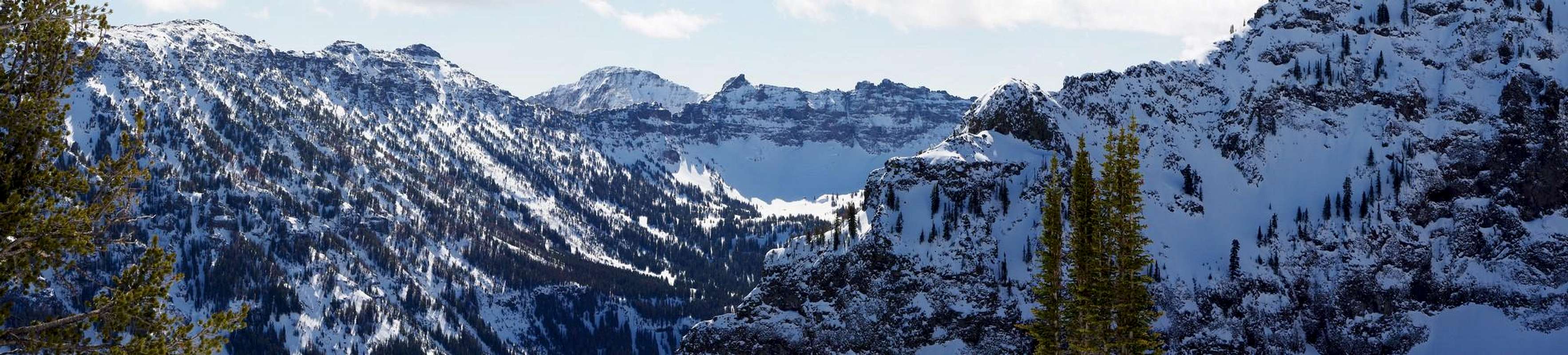
 Hyalite Peak
The ‘Maid’ is located on the west side of the canyon, around 3 miles south of the main Grotto Falls parking area and trailhead. The eastern aspect is nearly 1,500 vertical feet of craggy cliffs which doesn’t look particularly inviting at all, especially if you don’t have an idea of what the other sides look like. This is the end that is clearly visible from the main Hyalite trail. Both MMM and the mountain immediately north, Palace Butte, have similar profiles from the trail at a certain angle, so it is important to pay attention to the location on the trail before cutting up.
For the individuals willing to put in a little more effort bushwhacking and route finding off the traveled way, the Maid offers some great 360° views of the Hyalite area without the crowded feeling that you can experience on the popular Hyalite Peak during the late summer. From MMM the following named surrounding peaks are easily visible: Palace Butte, Mount Bole, Divide Peak, Hyalite Peak, Fridley Peak, Overlook Mountain, Flanders Mountain, The Mummy, Sleeping Giant Mountain, and Palisade Mountain. The Bridger range is visible past Gallatin Valley to the north.
Getting There
 Route
Route Creek bed route
 Top of creek bed looking west
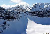 Divide Peak
 Mount Bole
 Elevation Profile
The trailhead:
Drive south out of Bozeman on 19th for about six miles. The road will bend right towards the west. Go about a mile after this turn, and turn left (will be a sign for Hyalite Canyon Road). Continue following this all the way to the reservoir and across the spillway. After the spillway the road will turn to dirt / washboard mud - be sure to wash your car the day before driving this... Keep on this road for several more miles, passing several campgrounds and boat launches next to the reservoir. Stay on the main road (right) when you see a fork leading to Palisade Falls and the Emerald Lake trailhead. Continue on for 2 miles and park at the Grotto Falls parking area / trailhead. I recommend getting to the trailhead before 9am if possible, as this is probably the most popular area in Hyalite area, even probably the Gallatin range, and can be hard to find room to park on weekends especially.
Trail/Route:
Head south on the main Grotto Falls trail. The first couple miles are the busiest. The trail forks and rejoins several times, which is not really an issue as long as you keep heading south in the canyon, you should eventually end up on the main trail. Within the first ¾ mile, you should be able to spot Palace Butte’s impressive cliffs on the right (west). Continue on the trail, passing Grotto and Arch Falls in that order. Soon you should be able to catch a few glimpses out of the trees at the Maid immediately adjacent to Palace Butte, with its impressive tapered cliff face.
After 2 miles total, start looking for a side trail on the left leading to Silken Skein Falls. I used this just as a guide to let me know I needed to start heading west up the drainage south of the Maid (which eventually would lead to Swim Lake if I kept following the creek). Around 2 1/3 miles in, cut due southwest and start bushwhacking through the thick lower trees. Cross the Hyalite Creek and continue this direction following the drainage up. Soon the trees should open up more and simply follow this draw up. Several sections have a few slightly exposed pieces, but nothing technical by any means.
I was able to cut short switchbacks with my skins on; straight up was too exhausting with the skis and also pushing my skins to their limits of holding me from slipping. This was the slowest portion of the route for me, I had to slowly climb this portion to avoid small cliffs near the creek while be confined to usually 20-30 feet side to side by the trees. After reaching the top of this draw, there is a large craggy ridge on the left with some gentle, leftover glacial moraines underneath. From this point, there are a couple options for the last push to the top of MMM.
First option (what I did and the most direct): Immediately start cutting back into the trees on the right. Keep climbing up 600-700 feet at which point it is pretty obvious where you need to end up. The trees here are much more sparse, making it pretty easy to thread through them. Don’t traverse too far right as you could end up on the cliffs if you’re not paying attention. The second option (which is how I came back down) is to continue up following the bumpy moraines at the top of the steep creek draw. When you start approaching the cliff headwalls straight ahead, start doing a U turn towards the small, mellow ridge leading to the Maid. This route adds about a mile compared to the direct route.
Keep in mind that I did this route in mid March, in more or less spring snow conditions. The steep creek draw has occasional slough (loose snow) runouts, and could definitely slab under the right conditions and take anyone in its path. So be sure to dig a few pits if climbing in the winter, look for recent avalanche activity, get a general idea of the snowpack, and be sure to check the Montana Avalanche center forecast for the day. I experienced very warm conditions the day I was in the area, and the wet snow saturated my ski skins and starting bonding to my skins… Not fun carrying an extra 10 lbs under each tele ski (which are not particularly light to begin with). Anyways, I don’t have much idea what this route would be like in the summer without 7 feet of snow on everything, so route finding skills would be advised.
Views from Top...
 |
Red Tape
 Hyalite peaks
Hyalite Canyon is all Gallatin National Forest... no wilderness, park, or recreation area regulations or special fees apply here. Check out the Gallatin Forest website and the MT Avalanche Center website for some great info and avy reports and forecasts. Use sustainable and low-impact trail practices and responsible backcountry etiquette; tread lightly, protect the watershed, and pack out everything you take in. Get ahold of Gallatin National Forest at 406-522-2520 or visit their website for more details. Help keep access open for everyone, as this area is heavily used - at least by Montana standards.
Camping
Hyalite Canyon has many designated campsites to accommodate different size groups and vehicles. These are located on the main canyon road both before and after the Blackmore trailhead. Camping is permitted as well within the forest, but do not set up camp right next to the trails, and keep a reasonably distance from streams and lakes. Contact the Bozeman District FS Office for more details about camping at 406-522-2520. Please do NOT camp at the trailheads or make ugly eyesore firepits.External Links
Gear in Bozeman:Prolite Gear, website, 406-582-0508, 421 West Griffin Drive, Suite 1, Bozeman
Barrel Mountaineering, 406-582-1335, 240 East Main, Bozeman
Northern Lights (and Barn), 406-586-2225, 1716 W. Babcock, Bozeman
Chalet Sports, 406-587-4595, 108 W. Main, Bozeman
Forest Service Office:
Bozeman District Office, 406-522-2520, 3710 Fallon St., Suite C, Bozeman