
-
 21496 Hits
-
 87.31% Score
-
 24 Votes
|
|
Mountain/Rock |
|---|---|
|
|
44.99032°N / 110.76678°W |
|
|
Hiking |
|
|
Summer, Fall |
|
|
9646 ft / 2940 m |
|
|
Overview
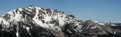
Two mountains, Electric Peak and Sepulcher Mountain, dominate the view from Gardiner, MT, the northern gateway to Yellowstone National Park. They are most impressive from Highway 89, just north (downhill) from Gardiner. The approaches to each lie within the park, from the south and east of the summits. Electric Peak from Sepulcher's Summit
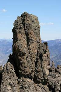
Sepulcher Mountain gets its name from the hoodoos on its false summit, which supposedly looked like tombstones (or sepulchers). One rock is particularly impressive (see photo).
There are fantastic views from the summit. A close-up view of Electric Peak dominates the west, but in all other directions you can see a very long way. We could see the Tetons, about fifty miles away, to the south.
 The Sepulcher, I presume
The two trails up the mountain offer very different features. From Mammoth, the Sepulcher Mountain Trail ascends through forests and then breaks onto a ridgeline to ascend the mountain from the east. From Gardners Hole, the Fawn Pass Trail follows the Glen Creek drainage through a forested canyon before using switchbacks to ascend the sagebrush flats on Sepulcher’s south side.
Easy links to multiple trails (Snow Pass, Hoodoos, and Bunsen Peak) make it possible to build many different loop trips from a base at Mammoth Hot Springs. Because the approaches vary considerably in terrain and flora, you get nice variety in your hike by choosing a loop route.
Getting There
Your base for climbing Sepulcher Mountain is the Mammoth Hot Springs complex in the northwest part of Yellowstone National Park. This complex is about fifteen minutes south of Gardiner, Montana, itself about ninety minutes from Livingston or a little over two hours from Bozeman’s airport.You can also approach Mammoth from inside the park, from anywhere on the Grand Loop Road.
Routes
Main routes
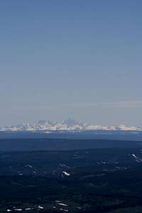 Tetons from Sepulcher
Sepulcher Mountain Trail. Start at the parking lot between the Stone House and the hot spring terrace. The trail starts up Clematis Gulch along the Beaver Ponds trail (which sees very heavy usage). After about three-fourths of a mile, leave the Beaver Ponds to their crowds and continue your ascent up a moderately steep trail. You soon enter a burn area with eastern exposure that will be hot when the sun is up. After switchbacking out of this stretch, the trail follows a ridge, mostly through cooler forests. The last half mile, which faces north and east, still had 3-6 feet of snow on it when we were there in mid June 2008, a heavy snowpack year.
This is about 5.5 miles one-way with 3400 feet of elevation gain.
South slope. Start at the Glen Creek trailhead, across the road from the Bunsen Peak parking lot. While crossing the flats of Gardners Hole, you’ll have good views of both Sepulcher and then Electric Peak. After two miles, you come to two junctions in quick succession. Continue straight ahead through a cool, forested canyon of Glen Creek. After this opens up, the Cache Creek trail diverges to the left. Head right up switchbacks through the sagebrush scrub of Sepulcher’s south side. This was snow-free until just below the summit in mid June 2008.
 Sepulcher from the south
This route is a bit over five miles one-way, with only 2200 feet of elevation gain.
Connecting trails
The Snow Pass Trail provides the shortest loop option, turning east from the bottom of Glen Creek’s canyon. After a mile, you can continue straight to the Snow Pass trailhead, either for a shuttle or for a descent through the Mammoth Hot Springs terraces. Alternatively, turn north around Clagett Butte to connect again with the Sepulcher Mountain trail and then down Clematis Gulch..
The Fawn Pass Trail (2.0 miles to the Glen Creek Trailhead) provides a shuttle option, or you can return to Mammoth via the Golden Gate and Hoodoos (about 4 miles). You could also cross over to Bunsen Peak, using the Bunsen Peak Loop Road to return to Mammoth (about 6 miles).
Red Tape
Ascending Sepulcher Mountain requires that you pay the Yellowstone NP entry fee or that you own one of the various annual passes for federal lands. Panoramic View to the South
Camping
 Electric Peak from Sepulcher
There is a NPS campsite just below Mammoth Hot Springs. It attracts the RV crowd.
There is a cluster of backcounty campsites 2-3 miles uphill from Gardners Hole on the Fawn Pass Trail, and a pair of sites below Cache Lake about 3 miles along the Cache Lake and Sportsman Lake Trails. Both groups are in the wrong direction from the Fawn Pass junctions, but you could use the latter pair (1G3 and 1G3) as base camps for climbing adjacent Electric Peak after descending Sepulcher.
External Links
You can find the official NPS site for Yellowstone here. Another pano to the south, from higher on the trail
Day Hiker - Jul 4, 2009 7:45 pm - Voted 10/10
lat/lonHi Arthur. The lat/lon on the page (44.90258, -110.87402) is incorrect, so the MyTopo link also shows the wrong place. From MyTopo, I got Sepulcher summit coordinates of 44.99032, -110.76678.
Arthur Digbee - Jul 4, 2009 8:32 pm - Hasn't voted
Re: lat/lonOK, thanks. I put your data down.