
-
 25359 Hits
-
 81.84% Score
-
 14 Votes
|
|
Mountain/Rock |
|---|---|
|
|
45.40363°N / 110.93007°W |
|
|
Mountaineering, Scrambling |
|
|
Summer |
|
|
10333 ft / 3149 m |
|
|

Overview
Because you are likely to see it in the morning and from the west, therefore looking into the sun, Mount Chisholm is not likely to inspire your photographic spirit, and the better views of other nearby peaks may tempt you to climb them instead. But Chisholm, along with Mount Bole, is the highest peak in the northern Gallatins, and its position on the eastern edge of the range provides spectacular views of almost every major peak in the Hyalite Canyon area, and ranges like the Absarokas and the Madisons and the Bridgers are visible as well. Views to the south show especially well the ocean of mountains that is Greater Yellowstone.
Routes
Chisholm is climbed relatively easily from the summit of Overlook Mountain, and most people will both approach and return from it that way, but it does offer an interesting Class 4 route and, for those who really want to get into a fight with the mountain, Class 5 options. While more challenging and dangerous than the route via Overlook, those routes do reduce the total elevation gain and slightly trim the distance.
The easiest route up Chisholm, up its south slopes from Fridley Creek, is difficult to access due to blockage by landowners, so most climbers will approach Chisholm from East Fork Hyalite Creek. The USGS Fridley Peak quad shows the peak and all of the trail.
From the East Fork Trailhead in Hyalite Canyon, the trail starts at about 6900’ and climbs to Emerald Lake (8900’) in 4.5 miles. The trail then skirts the western end of the lake and climbs another mile (really a little less) to 9200’ Heather Lake, which is just about at timberline. The trail between the lakes is often covered partially or totally by snow, and when the snow is gone, the area is very soggy; try to stay on the trail or on the snow in order to protect the fragile meadows up here. Wildflowers are usually spectacular in this area (as is the persistence of the mosquitoes around all this water and bog).
From Heather Lake, there are three climbing options.
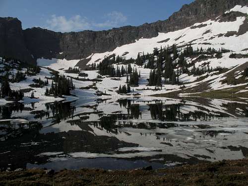 View from Heather Lake
Via Overlook Mountain
Climb Overlook Mountain first and then traverse to Chisholm. Study Overlook and decide on a course that looks good. There is no one way. The easier terrain is to the right of the summit, and going too far to the left will put you beneath cliffs you likely can’t or won’t climb without the protection of a rope. Because snow lingers in the basin and on the slopes well into July most years, it is a good idea to have an ice axe. You should have little trouble keeping the going at Class 2 and 3 when you are not on snow. This course is about 7 miles with 3800’ of elevation gain (tack on another 400 if you are going down via Overlook as well).
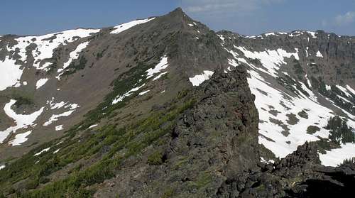
Northwest Couloir (Class 4)
I learned of this route from Thomas Turiano’s Select Peaks of the Greater Yellowstone. From Heather Lake, you can see two steep couloirs to the right of the summit. The one further right (nearer you) is the one Turiano describes. From the lake, the couloir may appear too steep to climb, but it looks better from above and directly beneath it. Turiano climbed it in June when snow filled it and could not vouch for the rock conditions when melted out; I climbed it in July (on my descent) when it was almost entirely melted out.
There are two Class 4 spots near the top where the couloir becomes very narrow and steep (some stemming may be required), but the rest is more moderate and will be on snow or scree. That scree is very loose, however, and it would be a bad idea to climb in a large group or even single-file in a small group in this couloir.
Unfortunately, the sun was in about the worst place it could have been for photographing the couloir from below when I was there, but this photo does show part of the couloir as seen from Heather Lake and will help with locating it in case there is confusion about which couloir to climb. This page also has some photos taken from the top of the couloir; those shots are below.
This couloir takes you directly to the summit ridge about 300 vertical feet below the summit, and the route is about 6.5 miles with 3400’ of elevation gain.
DO NOT use the couloir that leads more directly to the summit. It is definitely too steep for scramblers and has some obvious wet sections, too.
 Northwest Couloir
 Northwest Couloir
Saddle Direct
This also is about 6.5 miles with 3400’ of elevation gain and directly ascends the saddle between Chisholm and Overlook. Turiano’s climbing partner climbed this unroped on the day Turiano used the northwest couloir; it was watching his partner struggle up the cliffs that convinced Turiano to try the couloir even though he thought it looked too steep. Turiano estimated one of the moves his partner made as being 5.7 and does not recommend this route. Atop the ridgeline, I looked for weaknesses that would make for an easier way, but I did not see any; everything promising ran into sheer cliffs somewhere along the way.
Think about it; are you really going to carry rope and other gear for 13 miles just to use it on one 500’ section? Unless you’re comfortable free soloing 5.7 (I know I’m not), just use the first or second suggested route.
Summit Views


Getting There
From Main Street in Bozeman, take South 19th for 7 miles to the signed road for Hyalite Canyon. 11.5 miles up the canyon, shortly after the road passes Hyalite Reservoir and becomes unpaved, a signed junction indicates that you go left to access Emerald and Heather Lakes. Follow this road, which is rocky and rutted in places but passable to most cars, for 2 miles to the trailhead.
Red Tape
Be aware that the trail is a mixed-use one. It is open to hikers and horses every day of the week, but, from July 16 through September 4, it is open to mountain bikes Tuesday through Saturday and to motorbikes Wednesday through Saturday. Be alert, and do not assume that everyone heeds the restrictions; most do, but not all. From September 5 through July 15, the trail is open to hikers, horses, mountain bikers, and skiers every day.
Camping
There are several developed campgrounds in Hyalite Canyon, and the closest to the trailhead is Chisholm (2 miles away); sites for it and some of the other area campgrounds can be reserved at recreation.gov. If you don't have a reservation, get out here early on Saturdays and holiday weekends. There are also two rustic cabins nearby, Window Rock (closer) and Maxey, that can be rented through recreation.gov. Dispersed camping is widely available. No permit is required for backcountry camping.