
-
 17288 Hits
-
 86.85% Score
-
 23 Votes
|
|
Mountain/Rock |
|---|---|
|
|
45.02198°N / 110.6537°W |
|
|
Hiking |
|
|
Spring, Summer, Fall |
|
|
6735 ft / 2053 m |
|
|
Overview
 Western Rattlesnake: How Appropriate
Rattlesnake Butte lies near the Yellowstone River, not far from Gardiner, MT. It’s clearly visible from most spots in Gardiner, and likely to provoke the thought, “Can I climb that?” The answer is, of course, that you can climb that.
It’s not a noteworthy climb, but because of business obligations and sunset times I was constrained to outings that I could finish in about three hours. Rattlesnake Butte fit that bill nicely, with about two miles of trail each way to the base of the butte and then a scramble up a scree scope to the summit.
 Curious Doe
The summit is quite pleasant, with a large flat area covered with open woods. This makes a good shady spot to grab a snack before or after bagging the rock outcropping that marks the summit.
Getting There
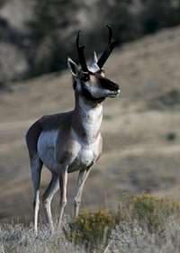 Buck Poses
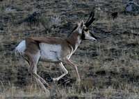 Pronghorn Country
From Gardiner, enter Yellowstone NP at the North Entrance. The road crosses a large flat, approaching the Gardiner River as it comes down from Mammoth Hot Springs. Park at the Rescue Creek Trailhead (marked) on your left.
From Mammoth, you’ll see the Rescue Creek trailhead on your right just as the road flattens out.
The Trail
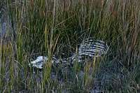 Skeleton on Turkey Pen Creek
From the trailhead, you’ll take the Rescue Creek Trail for about two miles in the direction of Blacktail Plateau. (Alternatively, you could descend from the Blacktail Trailhead on the Mammoth-Tower Road, but that’s longer and would require an ascent to get back to your car unless you shuttled down to Rescue Creek.)
The trail crosses the Gardiner River on a footbridge and ascends briefly the opposite bank. There’s what looks like a climber’s trail up Mount Everts to the right, but you want to stay left on the main trail. It crosses a pretty barren dirt flat for 500 yards or more - - a good illustration of how an overly-large elk herd has beat up parts of their winter range by overgrazing.
 Heroic Ram
After that, you turn a corner at the south end of Mount Everts and the terrain grows much more lush. There are numerous washes coming down the flanks of the mountain that water the next stretch of the trail. In late September, I saw a bighorn ram and several pronghorns feeding in this area.
Appropriately enough, I also saw a western rattlesnake on the way to Rattlesnake Butte. This is prime rattlesnake country, and it’s about the only part of YNP low enough to support rattlers - - so be aware.
 Turkey Pen Peak
As you get near the foot of Rattlesnake Butte, the trail turns to the south and ascends up Turkey Pen Creek. I saw a lot of skeletons and scattered bones here, which is a natural travel corridor for ungulates. During migration periods in fall and spring, I’d keep a close eye out for carcasses and any grizzlies that might be defending them.
The Climb
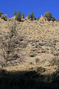 The West Slope of Rattlesnake Butte
Turkey Pen Creek ascends along the flanks of Rattlesnake Butte, eventually reaching near a saddle between Rattlesnake Butte and Turkey Pen Peak. I never saw any climbers’ trails on this side, but I didn’t go all the way to the point of the Butte.
As a result, the climb entails picking a spot and scrambling up. If you go farther up the trail you can turn more of the “climb” into a “traverse,” but you still cover a lot of scree no matter which route you pick. There are three outcroppings on the top of the butte, and the middle outcropping is the summit. I’d recommend aiming for the second “saddle” between the summit and the last outcropping that you see. (This would be the first outcropping you see if you’re descending from Blacktail.)
 The Summit
Technically speaking there would be a Class 3 move to stand on the true summit, but you could touch the summit with your hand and keep it at Class 2.
Because of the woods on top of the butte, there aren’t many views to the east. To the north there is a nice view of Turkey Pen Peak, and there are good views of Gardiner back behind you.
Red Tape
Yellowstone NP entry fees or annual multiagency pass. Mount Everts from the Summit
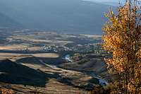 Gardiner from the Summit