
-
 2637 Hits
-
 75.81% Score
-
 6 Votes
|
|
Mountain/Rock |
|---|---|
|
|
28.24253°N / 16.56529°W |
|
|
Download GPX » View Route on Map |
|
|
Spring, Summer, Fall, Winter |
|
|
7815 ft / 2382 m |
|
|
Overview
 Montaña de la Angostura seen from the west Montaña de la Angostura seen from the west |
Montaña de la Angostura is one of the easiest mountains to climb on the caldera rim of the Cañadas del Teide. Still it is rarely visited thanks to the distances you have to hike from the closest trailheads. Moreover, depending on your route, you will have bagged higher summits befor you reach Montaña de la Angostura and since the Cañadas High Route avoids the summit, most visitors simply pass by.
 |  |  |
The Cañadas High Route connects the National Park Headquarters at El Portillo with the Parador Hotel in the centre of the Caldera. It always remains on the outside of the crater rim, passing by all summits with the exception of Montaña Pasajiron. It is more than 10km long and though it can be combined with the route across the Siete Cañadas on the inside of the crater the distance is long enough to deter anyone but the most stubborn hikers. Montaña de la Angostura is located in the middle of the route, which explains its relative unpopularity. Whoever walks there will have a long distance to cover.
 |  |  |
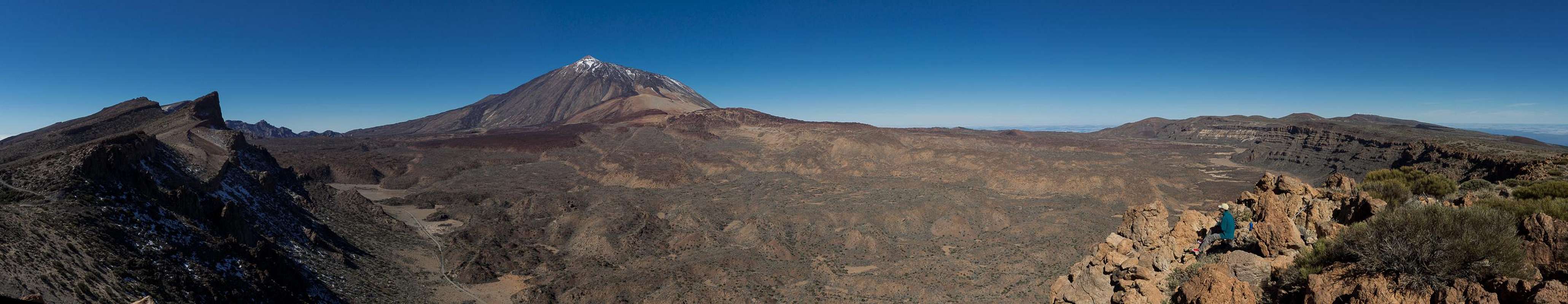
Like all of the rim mountains Montaña de la Angostura has a vertical inside face and a shallow slope on the outside. Here the inside face consists of a west face directed towards Topo de la Grieta and a north face directed towards El Portillo. The summit offers excellent views across the Cañadas del Teide, perhaps a bit surprising, as Pico del teide rises behind the broad backs of Montaña Rajada and Montaña Blanca. Another popular vie is the island Gran Canaria hovering above the south-east coast.
Summit panorama
  |
Getting There
 Roque de la Grieta, Topo de la Grieta and Teide. Here the ascent to the Angostura summit starts from the high route
There are two trailheads for reaching Montaña de la Angostura. One is the Cañadas Highway near the Parador Hotel, the other is near the National Park Headquarters at El Portillo.Both are connected by the Cañadas Highway (TF21)
There are four access roads to the Cañadas del Teide
- TF38 from Guìa de Isora (W)
- TF21 from La Orotava (N)
- TF24 (Cumbre Highway) from La Esperanza (E)
- TF21 from Granadilla (S).
The trailheads in the Cañadas come with parking lots. However, the ones near Parador Hotel and Roques de Garcia is notoriously overcrowded.
Routes
 The Izaña observatories on Cumbre Dorsal
Route from Parador Hotel
From the dead end roundabout south of the hotel a hiking path leads southward in direction of Guajara. It joins a dirt road running through the Siete Cañadas beneath the north faces of the rim mountains. This road avoids the rock cities near Piedras Amardillas. After having circled the Guajara north face it heads to a spot beneath Degollada de Guajara, which separates this mountain from Montaña Pasajiron. A brittle, narrow path leads up to the saddle. Turn left onto a steep path which heads directly to the summit plateau of Montaña Pasajiron.
Beyond the plateau a path heads down a broad ledge towards the next saddle. The regular hiking route now turns right, avoiding Roque de la Grieta. Follow it passing both Roque and Topo de la Grieta on the outside. The route gets wider, almost as wide as a dirt road but very rugged. After a 90° turn to the north the road bends eastwards, passing Montaña de la Angostura but always staying colse to the summit. Chose the best spot to hike over to the top.
Route from El Portillo
From the visitor centre cross the highway to hike down a dirt road, which heads down into the Cañadas. It splits after a few hundred metres and you need to take the left hand branch (trail No 2). Running eastward it hits an intersection, where you need to switch to trail No 8, which gradually heads for the caldera rim. In general you follow this path, which turns into a dirt road once you're on top of the rim and runs along its outside. The road passes Montaña de la Angostura in a wide turn. To reach the top of the mountain, chose the correct spot (several options) and hike to the summit.
Red Tape
The summit of Montaña de la Angostura is located on the border between the Parque Nacional del Teide which is composed of a giant volcanic crater the Cañadas del Teide with 48km circumference, and the Parque Natural Corrona Forestal, a natural park in which similar rules apply as in the national park. Trails are marked and it is not permitted to leave them. Strictly speaking, the summit should be off limits but this would apply to all other rim mountains except for Guajara.Accommodation
Of course you can find a lot of hotels, fincas and casas on the island which you can book from any travel office. The Cañadas del Teide have been declared national park so camping is not allowed. You might use the Parador Hotel which is supposed to be quite expensive, however. Better stay at one of the hotels at sea level and drive up by rental car or bus.The closest villages are Vilaflor and Aguamansa to the south and north of the Cañadas, respectively. Both offer inns and hotels but are not among the most popular tourist destinations.
Weather Conditions
There are several sites on the web which give you information on the weather on Tenerife. However, they all show the weather for the coastal regions (Puerto de la Cruz, Los Cristianos, La Orotava) which significantly differs from the weather in the Cañadas del Teide which are 2000m higher. The following table shows data for Puerto de la Cruz on the coast.
| Month | Jan | Feb | Mar | Apr | May | Jun | Jul | Aug | Sep | Oct | Nov | Dec |
| Avg. day temp.[°C / °F] | 19 / 66 | 19 / 66 | 20 / 68 | 21 / 70 | 22 / 72 | 23 / 73 | 24 / 75 | 26 / 79 | 26 / 79 | 24 / 75 | 22 / 72 | 20 / 68 |
| Avg. night temp.[°C / °F] | 13 / 55 | 13 / 55 | 14 / 57 | 14 / 57 | 16 / 61 | 18 / 64 | 19 / 66 | 20 / 68 | 20 / 68 | 18 / 64 | 17 / 63 | 14 / 57 |
| Water temp.[°C / °F] | 19 / 66 | 19 / 66 | 19 / 66 | 19 / 66 | 20 / 68 | 20 / 68 | 22 / 72 | 23 / 73 | 22 / 72 | 22 / 72 | 21 / 70 | 20 / 68 |
| Rainy days | 10 | 7 | 8 | 4 | 3 | 2 | 1 | 1 | 3 | 5 | 7 | 9 |
The Canary Islands are located in the trade wind zone. You almost always encounter northeastern winds which carry a lot of humid air. Being forced to climb to higher altitudes this moisture condenses into clouds. This in return means that most of the time the northeastern part of the islands is covered in clouds from altitudes of 1000m through 2000m.
The mountains themselves - being mostly of the same altitude - finally stop the clouds so that on their southeastern slopes the clouds "run out". In the case of Tenerife the Cañadas del Teide are so high that rarely ever you encounter fog or clouds. This on the other hand means that the whole area is very dry so be sure to bring your own water.
Maps & Books
Out of the multitude of maps and books I have been using the following. However, so far I have not found a good hiking map of the island. The one posted here is ok but shows only a fraction of the marked hiking trails. The guidebook is excellent but be careful if you do any one of the suggested "variations" to the tours described therein. The variations are described in a few words only and you might get the wrong impression of their quality.- Maps
- Teneriffa
Kompass Map WK233
Kompass Verlag
ISBN: 3-85491-038-X
- Teneriffa
Freytag & Berndt
ISBN: 978-3-7079-1061-2
- Teneriffa
- Books
- Teneriffa, Tenerife
K. & A. Wolfsperger
Rother Walking Guide
Rother Verlag
English - ISBN: 978-3-7633-4809-1
German - ISBN: 978-3-7633-4016-3
French - ISBN: 978-3-7633-4904-3
Spanish - ISBN: 978-3-7633-4700-1
- Teneriffa, Tenerife