Overview
![Roque de los Brezos]() Roque de los Brezos seen from the east Roque de los Brezos seen from the east |
Around 7 million years ago the island Tenerife established itself as a triplet of smaller island, which broke sea level in one of the deepest sections of the Atlantic Ocean. Later, the intervening sea (or lagoon) filled up first whith what turned into Cumbre Dorsal and later with the huge stratovolcano Teide, one of earth’s tallest mountains, when measured from sea floor to summit. Anaga in the north-east, Teno in the north-west and Adeje in the south are the remainders of the three aforementioned islands. Today they make up three low and small ranges but they may have soared up to about 2000m in their heyday. Erosion took away most of their substance so that today only the hardest rocks have been left standing. Often, these are very impressive towers standing tall above the washed out barrancos.
In the Adeje Range, south of mighty Teide only a few mountains have been left standing. The best known one is Roque del Conde, which towers above the port of Los Cristianos. A bit to the north you find a ridge of mountains and towers, Los Riscos, Roque de los Brezos and Roque Immoque. While the former are almost impossible to climb because of poor rock quality both Roque de los Brezos and Roque Immoque are hiking summits. In particular, Roque de los Brezos can be hiked easily.
The mountain consists of a twin peaked summit, high above deep Barrancos. This setting makes the mountain appear much more massive than it actually is and ensures a nice amount of exposure on the south face. To the north, the huge Teide slopes are close so that the shortest climb of Roque de los Brezos scales little more than 200m, especially since there is a parking lot for paragliders nearby, from which you can start. Roque de loz Brezos’ eastern summit is the slightly higher one of the two and there is a rain-collecting station on the western one (I think). From the wetsren summit you have very nice views down onto the towers of Los Riscos underneath.
A much better route is the hike from Vento (see below) including the summits of Roque del Conde and Roque Immoque. The summits all are panoramic and much of the hike towards the latter two runs along the right (western) side of a ridge which offers great views to the coast and beyond to the islands La Gomera and (sometimes) El Hierro.
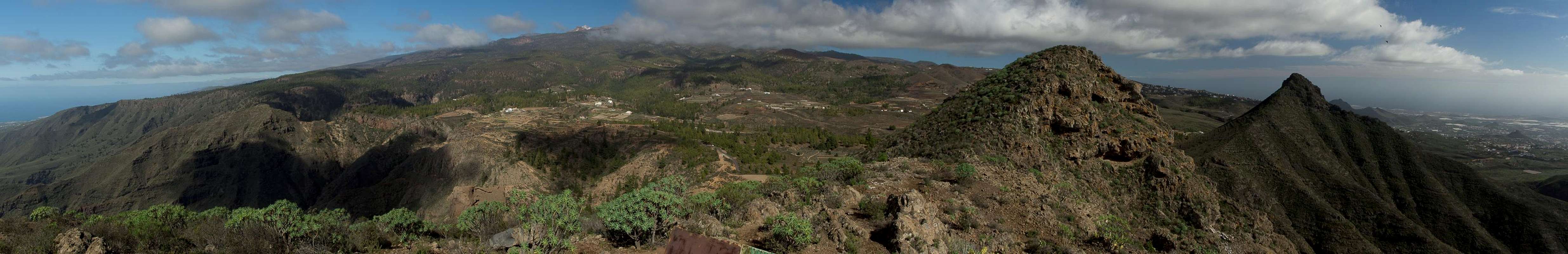
Summit Panorama
Looking north towards the huge bulk of the Teide Volcano |
Getting There
![Los Riscos, Roque de los Brezos, Roque Imoque]() Los Riscos, Roque de los Brezos, Roque Imoque seen from the summit plateau of Roque del Conde Los Riscos, Roque de los Brezos, Roque Imoque seen from the summit plateau of Roque del Conde |
- Take motorway TF-1 west to the exit Los Cristianos
- Switch to TF-28 north-east, direction La Camella
- Before you reach the village, TF-51 turns of northward to Arona
- Pass the town but right afterwards (after two curves (right / left)) turn left (west) into Vento
- In case you want to skip the hiking approach and start right at the saddle between Roque Imoque and Roque de los Brezos, stay on TF-51 until you reach La Escalona
- Turn left onto TF-567 to Ifonche, where a side road takes you south to a paraglider launch area. Park here or at the end of the road near a rural finca.
Route
![Los Riscos, Roque de los Brezos, Roque Imoque]() Los Riscos, Roque de los Brezos, Roque Imoque during the approach Los Riscos, Roque de los Brezos, Roque Imoque during the approach |
The most recommendable route starts at the hamlet
Vento, a "suburb" of
Arona. It heads out west from the village church, first along a road, later on a dirt track. It crosses
Barranco de las Casas and
Barranco del Ancón. Right after heading out of the Barranco the trekking trail
GR-131 passes from south to north. To the south you'll find the ascent to
Roque del Conde. Instead turn north and descend in the largest Barranco so far,
Barranco del Rey, which you'll have to follow for a few hundred metres. Get out on the far (western) side and follow
GR-131 to
Degollada de los Frailitos, where you have excellent views across the south coast of
Tenerife and across the channel to
La Gomera.
The route turns north again, passing a threshing place at
Casa de Suárez, then heads up to another threshing place, this one in the saddle between
Roque Imoque and
Roque de los Brezos. Turn left onto Roque de los Brezo’s east slope, which leads up to the higher east summit. The traverse to the west summit is somewhat tricky, with a brittle descent into the separating saddle. If you find the best path it’s a steep hike, otherwise little more than UIAA I. The ascent of the western summit is easy again.
Red Tape
I'm not aware of any red tape here, rather the contrary. The area is heavily used by paragliders and mountainbikers who (the latter) don't show much respect for pedestrians.
Parking space in Vento is very limited, you might have to leave your car outside the village boundary.
Accommodation
Of course you can find a lot of hotels, fincas and casas on the island which you can book from any travel office or over the internet. The closest tourist locations are at
Playa de las Americas and
Los Cristianos. In the towns of the closer area (
Adeje,
Arona) you can also find hotels and apartments, which might turn out rather more difficult, however.
Weather Conditions
There are several sites on the web which give you information on the weather on Tenerife. The following table shows data for Puerto de la Cruz on the north coast.
| Month | Jan | Feb | Mar | Apr | May | Jun | Jul | Aug | Sep | Oct | Nov | Dec |
| Avg. day temp.[°C / °F] | 19 / 66 | 19 / 66 | 20 / 68 | 21 / 70 | 22 / 72 | 23 / 73 | 24 / 75 | 26 / 79 | 26 / 79 | 24 / 75 | 22 / 72 | 20 / 68 |
| Avg. night temp.[°C / °F] | 13 / 55 | 13 / 55 | 14 / 57 | 14 / 57 | 16 / 61 | 18 / 64 | 19 / 66 | 20 / 68 | 20 / 68 | 18 / 64 | 17 / 63 | 14 / 57 |
| Water temp.[°C / °F] | 19 / 66 | 19 / 66 | 19 / 66 | 19 / 66 | 20 / 68 | 20 / 68 | 22 / 72 | 23 / 73 | 22 / 72 | 22 / 72 | 21 / 70 | 20 / 68 |
| Rainy days | 10 | 7 | 8 | 4 | 3 | 2 | 1 | 1 | 3 | 5 | 7 | 9 |
The Canary Islands (as well as Madeira) are located in the trade wind zone. You almost always encounter northeastern winds which carry a lot of humid air. Being forced to climb to higher altitudes this moisture condenses into clouds. This in return means that most of the time the northeastern part of the islands is covered in clouds from altitudes of 1000m through 2000m. The Teno and Anaga Ranges often are covered in clouds, though mostly along the north coast. The Adeje region often is the area with least precipitation on the island.
Maps & Books
- Maps
- Teneriffa
Kompass Map WK233
Kompass Verlag
ISBN: 3-85491-038-X
- Teneriffa
Freytag & Berndt
ISBN: 978-3-7079-1061-2
- Books
Out of the multitude of maps and books I have been using the following. It is excellent but be careful if you do any one of the suggested "variations" to the tours described therein. The variations are described in a few words only and you might get the wrong impression of their quality.
- Teneriffa, Tenerife
K. & A. Wolfsperger
Rother Walking Guide
Rother Verlag
English - ISBN: 978-3-7633-4809-1
German - ISBN: 978-3-7633-4016-3
French - ISBN: 978-3-7633-4904-3
Spanish - ISBN: 978-3-7633-4700-1

 4600 Hits
 75.81% Score
 6 Votes
 Roque de los Brezos seen from the east


 Los Riscos, Roque de los Brezos, Roque Imoque seen from the summit plateau of Roque del Conde
 Los Riscos, Roque de los Brezos, Roque Imoque during the approach