
-
 21777 Hits
-
 93.78% Score
-
 44 Votes
|
|
Mountain/Rock |
|---|---|
|
|
46.10747°N / 10.59593°E |
|
|
Trentino |
|
|
Mountaineering |
|
|
Summer |
|
|
11361 ft / 3463 m |
|
|
Overview
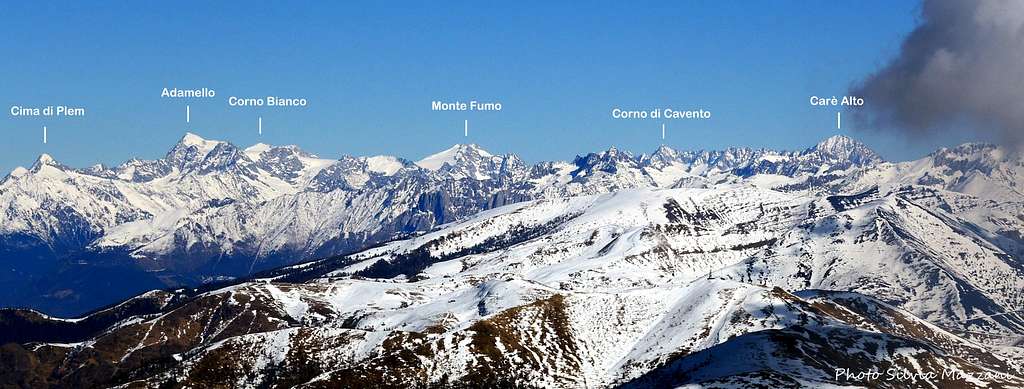
Geographical classification: Alps - Eastern part > Rhaetian Alps > Adamello Group > Carè Alto
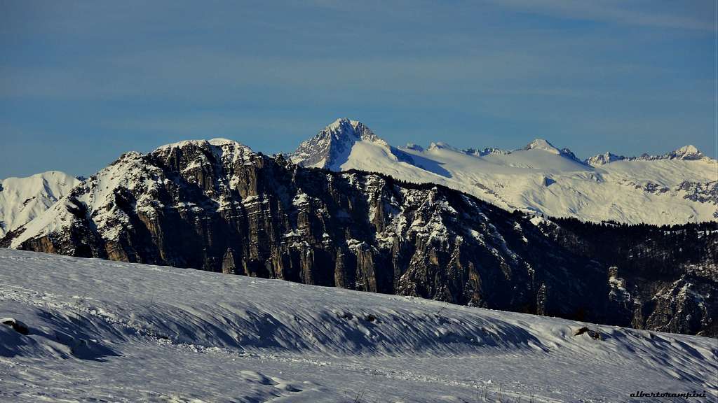
Carè Alto 3462 m
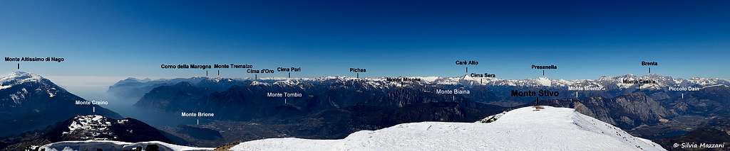
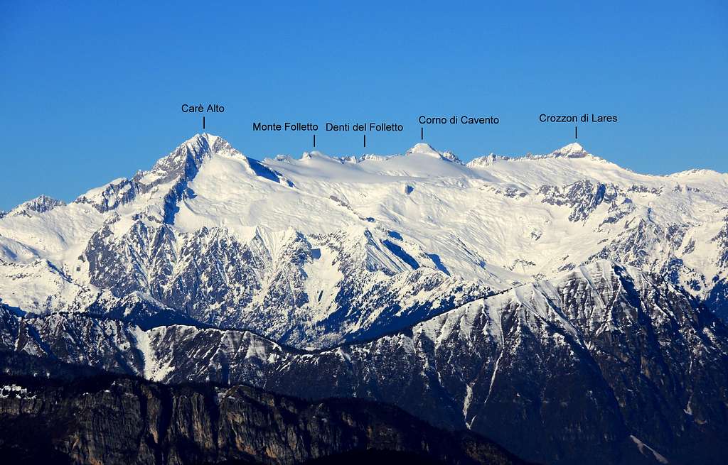
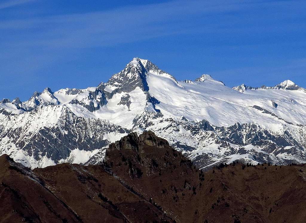
There are mountains that attract much more than others, Carè Alto is one of them! In fact Carè Alto is a great and fascinating mountain, complex and varied, belonging to the Adamello group and situated on the Southern edge of Vedretta di Lares ("vedretta" means "small glacier"), between Val Rendena and Val di Fumo (Trentino side of the group). It's a secluded and imposing peak, the highest one on the Adamello South-Eastern Sector, so that it's easy to recognize and identified its shape from a lot of kilometers of distance. Carè Alto is a highly coveted peak by mountaineers, in reason of its remarkable importance, the great historical value and the spectacular views overlooking the Val di Fumo (South) and Lares glacier (North).
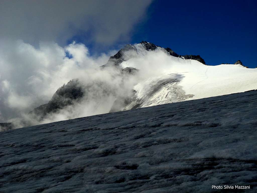
Besides the isolated position, the Carè Alto appeal comes also from the beauty and the variety of the appearance of the various faces. The rock is a particular kind of granite called "Tonalite" and the mountain terrain is highly complex: Carè Alto shows five major ridges, heading NE, E, SE, SW and NW. Amongst these five ridges the only one originating from the summit is the NW ridge, while the remaining four ones branch from the Northern fore-summit (N and E ridges) and the point 3361 or Southern fore-summit (SE and SW ridges).
East and North ridges enclose the Vedretta di Niscli and the Vedretta di Lares, identifying in the short but steep Northern wall one of the most classic ice-climbs on Adamello group, currently inadvisable due to the great ice-retrat taking place in the Adamello as in other mountain groups of the Alps. The conditions of its sides can change from year to year depending from the amount of snow. Also the Normal route on NW ridge shows a significant withdrawal of the snow, in fact the route in summer presents short stretches of rock climbing.
Due to the beauty of its shapes and the steepness of its slopes, the Carè Alto has always aroused great interest from the mountaineers and has been climbed along many different itineraries on all sides. Consequently there are various routes to get the summit of the peak, but few of them are still currently climbed, being the most popular the ones departing from Rifugio Carè Alto. The Normal route on the NW ridge is one of those and retraces the itinerary of the first climbers. Unlike the Normal routes of some mountains of the Adamello group, such as the Normal routes to Adamello and Corno di Cavento, which are technically easy, this itinerary although not difficult requires a certain mountaineering skills. In fact the ice retreat mentioned above produces a significant withdrawal of the snow on the Normal route, which in fact in summer presents short stretches of rock climbing.
Getting There
Road access to Val Rendena
Coming from Autobrennero exit Trento and take the road to Riva del Garda, reaching the village Le Sarche. Here continue straight toward Tione di Trento.
Road approach to Rifugio Carè Alto - In Tione turn to right and take the SS 239 Val Rendena route towards Pinzolo and Madonna di Campiglio, reaching Villa Rendena, Vigo Rendena, Pelugo and Borzago. In Borzago leave the main road 239 and take on the left the road entering Val di Borzago (signposts Rifugio Carè Alto), reaching the small hamlet of Case di Fe 1087 m, then Pian della Sega (7 km. from Borzago), where you must park the car (wide parking lot).

|

|
A gravel road continues up for a few kilometers, but it’s close to private cars.
A bit of history
The first summiters of Carè Alto were H.F. Montgomery and S. Taylor starting from Valle di Borzago, through Sella di Niscli and North-West Ridge, the same route of the current Normal route. The two British climbers were successful in the year 1865, August,8th, after they had attempted the climb to the summit starting from the Val di Fumo some days before the first ascent. As known, Adamello group was one of the main alpine groups to be strongly affected by the WWI between the Austro-Hungarian Empire and the Kingdom of Italy, as the border between the two states was running right along this chain at that time.
Although the summit of Carè Alto was not directly affected by the fighting - as the nearby Corno di Cavento - it was garrisoned by the Austro-Hungarians and served with a cable car. On Carè Alto east ridge, between the Refuge Carè Alto and the summit, the current Bocchetta del Cannone, was installed a cannon Skoda, now restored on its original location. The whole Carè Alto area had a great strategic importance for the Austrians, who guarded also the ridge Monte Fumo - Lobbia Alta and the ridge Corno di Cavento - Crozzon di Folgarida. The Carè Alto hut was equipped as a military citadel. The remains of these war-works are still visible throughout the area.

Carè Alto main routes
- Normal Route on NW ridge
Difficulty: Alpine PD
Difference in level: 1000 m from Rif. Carè Alto
Exposure: North-West
Hut: Rifugio Carè Alto m 2459
Starting point: Valle di Borzago (Val Rendena)
The ascent from this side (route of the first summiters), doesn't oppose particularly difficult, but it requires glacier good practice and knowledge of rope work (possible downhill rappelling).

|

|
From Rifugio Carè Alto - Dante Ongari take the path n. 215 starting just behind the building, descending the rock staircase of “Bus del Gat”, then starting to cross the basin below Vedretta di Niscli. Soon cross a stream (Rio Bedù) along a cable bridge and continue to rise up the valley along the moraine reaching Sasso Bagnato, where there is a junction. The main trail goes right to Passo Altar, we keep the left and continue up a moraine ridge reaching Pozzoni rocky band overlooking the small lakes and the saddle named Sella di Niscli 2912 m. (signposts) to the right of Sass de la Stria. From the saddle cross uphill the Vedretta di Lares, at first in the West direction, then in the South direction, heading towards the North side of Carè Alto. Once getting the base of the mountain there are two possibilities:
A - climb directly a brief steep icy or snowy slope located immediately to the left of the North West ridge and reach the NW ridge in its central section, if the ice conditions are good
 slope. But...")

B - in full summer the ice condition is often bad, so it's better to climb the ridge on the right, alternating snowy ridges and rock steps, cross the North fore-summit and after a ridge and a notch reach the summit. Getting (marked) to the foot of the NW ridge (marks) the itinerary rises slightly diagonally along the ramps up to an anchor just below the ridge (an anchor is also present in the lower part of the initial ramp, visible depending on snow). Continuing as much as possible along the edge of the ridge (marked) to the summit.
Descent: reverse the same route. In the lower part one or two abseils are possible from the two fixed anchors to get to the Vedretta di Lares.
- East Ridge aka Cerana Ridge
Difficulty: Alpine AD-, UIAA II-III
Difference in level: 1000 m from Rif. Carè Alto
Exposure: East
Hut: Rifugio Carè Alto m 2459
Starting point: Valle di Borzago (Val Rendena)
From Rifugio Carè Alto reach Bocchetta del Cannone 2830 m; from here go down a few meters in the direction of the ridge. Continue at first on the moraine, then on mixed terrain and snow-fields, in the direction of Conca glacier (Vedretta di Conca). After getting the steep glacier, rise up to the ridge in the direction of a short rock wall engraved by a slanting crack (UIAA III, 30 m), that allows you to gain the summit of the ridge (2,30 h from the hut). Now follow the ridge, alternating rock steps (UIAA II) and snowy or icy stretch, reaching the WWI remains and heading left to get the summit cross.
 |
 |
 |
 |
- South-West Ridge
Difficulty: Alpine PD+, UIAA II+
Difference in level: 400 m from Bivacco Segalla
Exposure: SW Hut: Bivacco Segalla m 3050
Starting point: Val Daone (Lago di Malga Bissina)


This route starts from Bivacco Segalla. From the bivouac head to North up on debris to get the top of the slope, then downclimb on easy rock steps toward a notch above Carè Alto Southern glacier, following some iron ropes and wire (do not trust too much of the equipment on site), and bypassing a tower on the right. From here start to climb following traces up to a dihedral (iron rope), which is the only important climbing step of the route. Continue along the path to a second dihedral, easier than the first one, then follow the old equipment that lead us at first to a slab to cross (iron rope) and then on the ridge, passing near a hut destroyed on the bottom of a gully.


Cross a short stretch usually snowy, then on debris reach the Southern fore-summit. From here downclimb briefly aided by an iron rope, then climb directly to the summit.
Red Tape

No fees no permits needed and no particular restriction in climbing and hiking. Carè Alto is situated within Adamello-Brenta Natural Park, the largest protected area in Trentino, established in 1967. It's located in Western Trentino and with its 620.51 square kilometers includes the mountain groups of Adamello, Presanella and Brenta Dolomites, separated by Val Rendena. Camping is not allowed and fires are strictly forbidden. The parking lot in the two Valleys (Fumo and Borzago) is free. In winter time the roads entering Val di Fumo and Val di Borzago may be closed due to snow cover.
Huts

-Rifugio Carè Alto-Dante Ongari 2459 m
Situation: East ridge of Carè Alto, on the side of Val Conca (Val di Borzago)
Open: from June 20th to September 20th
Size: 82 persons Winter-shelter: 8 persons
Owner: SAT Trento
Guardian: Marco Bosetti and family
Refuge's phone: +39 348 4359097 - +39 340 2943731
Walking approach - From the parking lot Pian della Sega in Val di Borzago (m 1250) take the old mule track through the woods and follow it until the alp Coel di Pelugo 1440 m. (30 minutes) from where it starts the cable car to the refuge. Take the path SAT 213 rising along steep turns, reach a tibetan bridge on a stream (rio Bedù di Pelugo), cross it and rise to the plateau above, traverse left and walk up the large rocky step, getting to the refuge (3,30 hours from Pian della Sega, difference in level 1200 m).

-Rifugio Ai Caduti dell'Adamello alla Lobbia 3040 m
Situation: Western slopes of Lobbia Alta, on the sidelines of Vedretta Mandron.
Open: summer from June 20th to September 20th - winter from March 5th to May 1st
Size: 100 persons
Owner: CAI Brescia
Guardian: Romano Bertero Ceschini
Phone: +390465502615 - Mobile: +393356664234
Walking approach - From Refuge Bedole take the path n. 212 that crossing a stream (rio Ronchina) rises with many hairpins reaching Crozzetti 2253 m, the junction with the "Migotti" path n. 220. Keep left and proceed with less steeply, passing near the old Rifugio Mandron 2429 m and arrive in a few minutes to the new Rifugio Mandron. From here follow the trail No. 236 that skirting the Mandron lakes leads to the foot of the Glacier of Mandrone. Go up the moraine, snow and debris along the left side bank of the glacier until around 2800 m, where you turn left (signposts Rifugio Lobbia Alta), crossing the glacier to SE and reaching the refuge.
When To Climb


")

The best period goes from June to September
Meteo

Guidebooks and maps

-Guidebooks
"Adamello Vol. I - Pericle Sacchi Collana Guide dei Monti d'Italia CAI-TCI
-Maps
"Adamello - Presanella" - Tabacco scala 1:25000
"Adamello, Val di Fumo, Val di Genova" - Kompass n. 638
"Adamello - Presanella" - 4LAND Alpine Cartography n. 138 1:25.000