
-
 39293 Hits
-
 91.45% Score
-
 35 Votes
|
|
Mountain/Rock |
|---|---|
|
|
43.15080°N / 109.6305°W |
|
|
Hiking, Mountaineering, Trad Climbing, Ice Climbing, Mixed, Scrambling, Skiing |
|
|
Spring, Summer, Fall |
|
|
13620 ft / 4151 m |
|
|
Overview
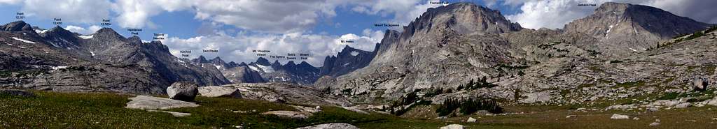
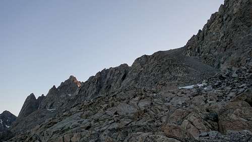
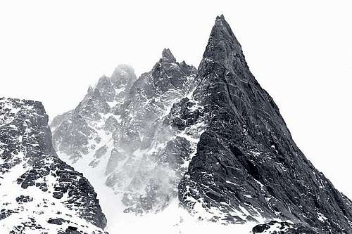
Mount Helen is a thirteener in the Wind River Range and Wyoming's fifth highest peak (see the WY 13ers list here). The fourth highest peak in the range, it is known for its graceful symmetry in appearance, the popular rock of Tower Ridge, and its fine alpine routes. The west side of the Continental Divide-straddling peak towers over the upper reaches of Titcomb Basin. From the meadows of the basin, Tower 1 rises 1800' in a vertical spire of migmatite-banded gneiss. The routes on Tower 1 are considered classics and climbers sometimes make the two-day approach into the valley just for a climb of this tower. The Tower Ridge route (III, 5.7+), which takes in the next two towers and the summit knob, is one of the best alpine rock moderates in the Central Rockies. Tucked in between Towers 1 and 2 is the Tower 1 Gully, considered by some to be the best summer ice route in the range. Adjacent to this is the Grand Couloir (NW couloir) which is one of the finest and longest snow climbs in the range.
The east side of the peak features the long and wide east ridge which separates Helen Glacier from Sacajawea Glacier. The north face of the ridge supports steep, glacial alpine routes. In between features on this side are several Class 4 and up mixed routes, all of which lead to the Class 4 summit blocks. There are crevasse and bergschrund difficulties on east side routes. Descents can be made via chutes leading from near the top of the East Ridge to Sacajawea Glacier, via the Grand Couloir or the North Ridge to Helen Col (12561'). With a multitude of fine, challenging routes, and snow/ice that stays in condition throughout the summer, Helen is one of the more popular peaks in the northern half of the range and sees up to a dozen ascent parties each year.
 |
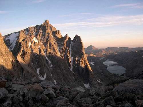 |
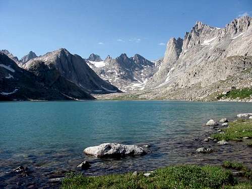
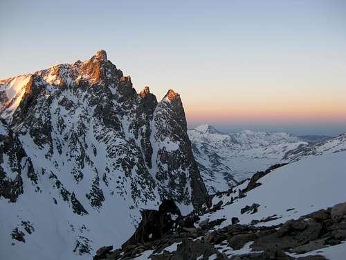
| Helen (right) at the head of Titcomb Basin (photo: zzippyy) | Sunset on Helen from Bonney Pass. Tower 1 Gully is the ice seam between Tower 2 and Tower 1 (photo: asmrz) |
Getting There
Use the Elkhart Park Trailhead accessed from Pinedale on the west side of the range and hike the Pole Creek Trail to Island Lake, passing by Photographers Point and Seneca Lake along the way. Just after passing over a small divide at 10,660 feet Island Lake will come into view. Descend to it and continue to the junction with the Titcomb and Indian Basin trails. Take the Titcomb Basin Trail heading north/leftward and hike past Lower and Upper Titcomb Lakes as the trail follows along their east shores. Base camp can be set up about 0.5 mile past the upper lake where many rock shelters have been built by Gannett Peak climbers and other backpackers.
Other approaches are outlined below. These approaches are a bit longer and require additional off trail travel than the standard approach outlined above.
Northern Approach via the Glacier Trail to Helen Glacier - 4 miles east of Dubois, turn south from highway 26/287 and follow the recently improved dirt road (FS #411; passable in cars) eight miles past Trail Lake Ranch to its end. The Glacier Trail is then taken for approximately 23 miles to the Dinwoody moraine. From here, cross either Blaurock Pass or Backpackers Pass to the Helen moraine.
Indian Pass/Bull Lake Glaciers Approach - This classic wilderness outing utilizes the Titcomb Approach as far as Island Lake. From there, the Indian Basin trail is followed 3 miles east to Indian Pass on the Continental Divide. The rest of the route utilizes a traverse NW over the high glaciers and moraines to the Sacajawea Glacier, SE of the peak.
Standard Route - East Ridge Class 4
Mount Helen is most easily reached via it's long east ridge, which can be accessed in a number of places both on its north and southern flanks. From the normal approach via Titcomb basin, ascend the south to north oriented talus ramp that starts at the base of the 1500 foot near vertical west face of Mount Sacajawea. From the camp in upper Titcomb, aim for a small break in the lower set of cliffs that are 500 feet above the upper lake. This break is more or less directly below the summit of Sacajawea. You can scramble through on a series of grassy ledges and small boulderfields. Once you reach the 11600 foot level, you can curve sharply back north and continue on an ascending traverse to the base of the ramp around 11950 feet. From here, it's a grueling 900 foot ascent up the ramp, which doesn't exceed class 3. Game trails are abound on this ramp, although the animals wreck all the talus and make it looser. I found it easiest to ascend the left edge of the ramp on somewhat more solid rock.
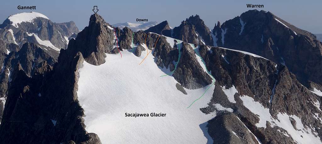
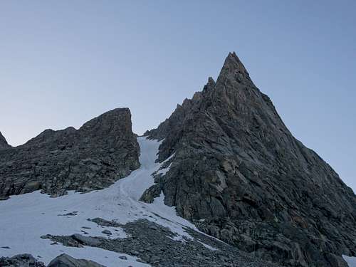
Crest the divide ridge at 12800 feet and cross over to the east side and begin a traverse north initially on easy talus near the crest, but then avoiding the rocky narrow ridgecrest by traversing the upper edge of the Sacajawea Glacier near where it terminates against the ridge. Closer to Helen, you'll descend slightly to another broad low spot in the ridge at 12790 feet, where the south ridge of Helen steepens dramatically. Cut right and leave the ridgecrest here in favor of the upper snow slopes of the Helen Glacier. Make an asacending traverse generally north, aiming for one of many south facing gillies that lead to the east ridge of Helen. Depending on the time of year, the easiest of these gullies may change based on snow covereage, whether any bare ice is present, how steep they are, or how loose the rock is. See the annotated photo below for a general overview of the various access gullies to the east ridge, colored by range of difficulty (green = easier & red = harder). The green one closest to the summit was my obvious choice when I climbed Helen, however the two green ones further east are slightly easier (35 degree snow) but not likely worth the extra distance. Once you crest the east ridge, it's a straightforward scramble to the summit, with one or two 4th class spots in the final 50 feet to the top with moderate exposure.
If time, energy and weather allow, combining this route with a climb of Mount Sacajawea makes for an excellent outing from Titcomb Basin. Descent is by the same talus ramp you came up. The east ridge can also be reached from its north flank by a handful of steeper, more difficult gullies that hold snow most of the summer. Parties looking to continue north towards Spearhead Pinnacle or Mount Warren can do so by negociating various options dropping off the north side of the ridge, all of which will include loose 4th class rock, or 45 degree snow depending on the exact route chosen.
Management and Regulations
The west side is managed by the Bridger Wilderness and National Forest. The east side is managed by the Fitzpatrick Wilderness of Shoshone National Forest. Wilderness regulations apply for camp locations, group size, campfire restrictions and ethics. There are no permit requirements in these two wildernesses. Minimum-impact camping and travel ethics are increasingly important at Double Lakes cirque, Seneca Lakes and in Titcomb Basin. It is more ethical and less buggy to avoid camping alongside lakes in this range. Backpacking stoves are required and water filtration is suggested. A fee-based campground exists at the Elkhart Park trailhead. There is undeveloped camping at the Torrey trailhead.
Seasonal Conditions
Summer season in the Wind Rivers is generally July-September with snow lingering on the higher trails into July. A snow storm is traditional between the last week of August and the second week of September. This is normally followed by a dry period with crisp temperatures for 2-5 weeks. Crevasses on the Fremont/Bull Lake Glaciers are hidden in June and begin opening sometime in July. The snow & ice routes vary year to year but tend to remain in good condition into mid-summer. The road to the Torrey Lakes/Trail Lake trailhead is often reachable year-round, the exception being during April and May snowstorms. The road to Elkhart Park (the only paved road in the range) is plowed to within 2.5 miles of its end in the winter - about 2 miles past the turnoff to White Pine. The approach is heavy with mosquitos June thru August. Water must be carried the first 10 miles of the Glacier Trail. Ski approaches are generally much gentler than in other remote ranges of the Rockies. An area webcam depicts current conditions.
Map
This map shows the standard route up Mount Helen with a green line from a typical camp in Titcomb Basin. Combining with Mount Sacajawea is also displayed.
Other Popular Routes
Grand Couloir (II, 4) - The great snow couloir on the northwest face is pleasant and varies year to year; sometimes becoming icier (and dirtier) by early autumn. It is fairly wide, 1000-1400 feet tall and goes at Class 3-4 in good conditions, varying between 35 and 50 degrees. The top reaches the east ridge which is followed west to the Class 4 summit blocks. It is often the most expedient route from Titcomb and offers a quick descent option with the proper gear, albeit with rockfall danger in afternoons.
Tower Ridge (III, 5.7, traditional rating) - The classic and much compared rock route up the edge of Tower 1 (5.6) and then continuing over Tower 2 and around Tower 3. The finish on the summit pitches is classic (5.7-5.8). The south side of Tower 2 can no longer be traversed around, and recently have required parties to climb over it.
West Face (V, 5.10 A2) - A Beckey classic on the 1,500-foot gneissic wall.
Tower 1 (Ice) Gully (IV, Ice) - The ice climb up the north couloir between Towers 1 & 2. Grade IV includes summit pitches.
North Face (II, 5, snow) - Steep snow then rock from Helen Glacier directly to the east ridge.
|
|
History & Etymology
Mount Helen was named by Green River Basin residents for 'Helen Fisher' 20 years before it was actually climbed. It is the 5th highest peak in Wyoming. In 1923, Colorado Mountain Club member Carl Blaurock discovered the Wind Rivers and learned that three of its five highest summits had remained unclimbed. The following year Blaurock's climbing partner Albert Ellingwood proposed a trip to the Tetons and Carl explained the potential of the nearby Winds. Entering the range with friend Herman Buhl and his wife, they headed straight for Mount Helen, ascending to the summit after gaining the east ridge from the north ridge via Helen Glacier and Helen Col. Two days later they made the first ascent of the North Face of Fremont. Two days after that they made the first ascents of Turret and Warren, followed the next day by one of the earliest ascents of Gannett. Packing out, they headed for the Tetons where they ascended the Grand and, two days later, made the second ascent of Moran. In a span of two weeks they had made a total of two ascents in the Tetons and six in the Winds - three of them first ascents. In 11 days they had climbed the six highest peaks in the state and did so before constructed trails with wool, leather, heavy tarps, fire, a lack of topographical maps and mostly dirt roads from Denver! Their achievement would be very challenging to repeat even with new roads, the construction of trails and modern gear.
In 1946, Hans Kraus and Roger Wolcott made the historic ascent of Tower Ridge. In 1971, Laramie climbers Ray Jacquot and Bill Lindberg brought their ice skills (honed in the Tetons and the Snowy Range) to the Tower 1 couloir. Fred Beckey put up the center of the West Face of Tower 1.
External Links
Bonney, O.H. (1977). Guide to the Wyoming Mountains, 3rd Ed.; Swallow Press. Chicago,IL.
Euser, Barbara (1984). A Climbers Climber: On the Trail with Carl Blaurock; Cordillera Press.
Kelsey, Joe (1994). Climbing and Hiking in the Wind River Mountains, 2nd Ed.; Falcon Press. Guilford, CT.