
-
 4804 Hits
-
 76.66% Score
-
 7 Votes
|
|
Mountain/Rock |
|---|---|
|
|
28.23633°N / 16.57829°W |
|
|
Hiking, Scrambling |
|
|
Spring, Summer, Fall, Winter |
|
|
8533 ft / 2601 m |
|
|
Overview
 Topo de la Grieta seen from Montaña de la Angostura Topo de la Grieta seen from Montaña de la Angostura |
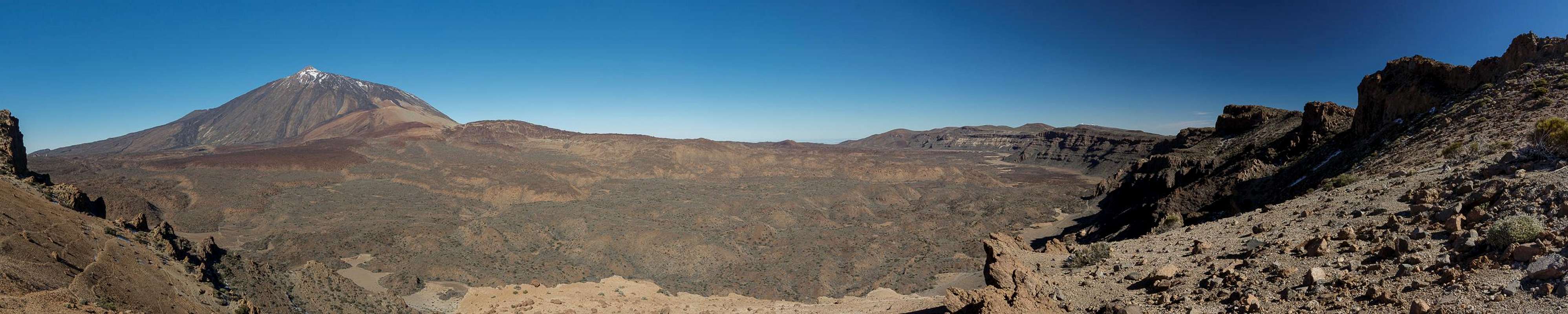
All the highest mountains of Tenerife are located in the Cañadas del Teide, the giant erosion crater left over after an older Volcano slid northwards into the Atlantic through what is now Valle de Orotava. Besides Teide itself and its satellites Pico Viejo and Montaña Blanca, all important mountains lie on the caldera rim which stretches in a 240° circle around Teide. All of these mountains are more than 2000m high, the lower ones to the north-east and west with the highest and most impressive ones in the south. The bulky form of Guajara is the highest and most popular of these mountains but the most striking one lies somewhat to the east and is called Topo de la Grieta.
 |  |  |
At 2602m it is the second highest of the rim mountains. Seen from the Cañadas or from the top of Teide, Topo de la Grieta looks like a asymmetrical pyramid, a triangular mountain, which rises vertically from the base of the crater but drops gradually on the outside. Still, when seen up close the outside slope turns out to be very steep, which results in very few visits of the mountain. Located midway between two far away trailheads reaching Topo de la Grieta requires long hikes of more than 20km (on the return trip) even to reach the southern base of the mountain. Hiking, however is easy until you prepare for the final scramble and bushwhack to the top.
 |  |  |
Like Guajara or any other of the rim mountains, Topo de la Grieta is a perfect lookout across the giant crater. Teide looms on the other side of the crater and the Cañadas themselves are at your feet. On clear days you can see four more islands on the horizon: Gran Canaria to the south-east, El Hierro, La Gomera and La Palma to the west. In addition the south coast lies at your back while the Cumbre Dorsal Range stretches far into the east.
Getting There
 Gran Canaria above the caldera rim
There are two trailheads for reaching Topo de la Grieta (actually there are more but they all start far down on the southern outside of the Cañadas del Teide that they don't make much sense). One is the Cañadas Highway near the Parador Hotel, the other is near the National Park Headquarters at El Portillo. Both are connected by the Cañadas Highway (TF21)
There are three access roads to the Cañadas del Teide
- TF38 from Guìa de Isora (W)
- TF21 from La Orotava (N)
- TF24 (Cumbre Highway) from La Esperanza (E)
Both trailheads come with parking lots. However, the ones near Parador Hotel and Roques de Garcia is notoriously overcrowded.
Route
 Topo de la Grieta seen from Cañada de la Grieta
Route from Parador Hotel
From the dead end rouandabout south of the hotel a hiking path leads southward in direction of Guajara. It joins a dirt road running through the Siete Cañadas beneath the north faces of the rim mountains. This road avoids the rock cities near Piedras Amardillas. After having circled the Guajara north face it heads to a spot beneath Degollada de Guajara, which separates this mountain from Montaña Pasajiron. A brittle, narrow path leads up to the saddle.
Turn left onto a path which heads across Montaña Pasajiron. After the next saddle (with Roque de la Grieta) it turns into a broad path, which passes the two plateau summits of Roque de la Grieta on the outside. Start scrambling up to Topo de la Grieta from the next saddle or head onwards to its far side (another saddle), from where you can follow the east ridge of the mountain.
 Topo de la Grieta and Teide seen during the ascent of Montana de la Angostura
Route from El Portillo
From the visitor centre cross the highway to hike down a dirt road, which heads down into the Cañadas. It splits after a few hundred metres and you need to take the left hand branch (trail No 2). Running eastward it hits an intersection, where you need to switch to trail No 8, which gradually heads for the caldera rim. In general you follow this path, which turns into a dirt road once you're on top of the rim and runs along its outside. After having passed Montaña de la Angostura you hit a saddle from which you can follow the east ridge to the top (some exposed) scrambling or bushwhack across the centre of the south-west face of Topo de la Grieta.
Red Tape
  |
Topo de la Grieta is located on the border between the Parque Nacional del Teide which is composed of a giant volcanic crater the Cañadas del Teide with 48km circumference, and the Parque Natural Corrona Forestal, a natural park in which similar rules apply as in the national park. Trails are marked and it is not permitted to leave them. Plants may not be removed and the few animals have to be left alone. Some places in the Corrona Forestal Park are private hunting grounds but not in this part close to the Cañadas.
Topo de la Grieta seems to have been used for military practise of some kind during the past. There are still signs warning you not to trespass onto military ground. Little is to be seen, however, of recent military usage.
Accommodation
Of course you can find a lot of hotels, fincas and casas on the island which you can book from any travel office. The Cañadas del Teide have been declared national park so camping is not allowed. You might use the Parador Hotel which is supposed to be quite expensive, however. Better stay at one of the hotels at sea level and drive up by rental car or bus.The closest villages are Vilaflor and Aguamansa to the south and north of the Cañadas, respectively. Both offer inns and hotels but are not among the most popular tourist destinations.
Weather Conditions
There are several sites on the web which give you information on the weather on Tenerife. However, they all show the weather for the coastal regions (Puerto de la Cruz, Los Cristianos, La Orotava) which significantly differs from the weather in the Cañadas del Teide which are 2000m higher. The following table shows data for Puerto de la Cruz on the coast.
| Month | Jan | Feb | Mar | Apr | May | Jun | Jul | Aug | Sep | Oct | Nov | Dec |
| Avg. day temp.[°C / °F] | 19 / 66 | 19 / 66 | 20 / 68 | 21 / 70 | 22 / 72 | 23 / 73 | 24 / 75 | 26 / 79 | 26 / 79 | 24 / 75 | 22 / 72 | 20 / 68 |
| Avg. night temp.[°C / °F] | 13 / 55 | 13 / 55 | 14 / 57 | 14 / 57 | 16 / 61 | 18 / 64 | 19 / 66 | 20 / 68 | 20 / 68 | 18 / 64 | 17 / 63 | 14 / 57 |
| Water temp.[°C / °F] | 19 / 66 | 19 / 66 | 19 / 66 | 19 / 66 | 20 / 68 | 20 / 68 | 22 / 72 | 23 / 73 | 22 / 72 | 22 / 72 | 21 / 70 | 20 / 68 |
| Rainy days | 10 | 7 | 8 | 4 | 3 | 2 | 1 | 1 | 3 | 5 | 7 | 9 |
The Canary Islands are located in the trade wind zone. You almost always encounter northeastern winds which carry a lot of humid air. Being forced to climb to higher altitudes this moisture condenses into clouds. This in return means that most of the time the northeastern part of the islands is covered in clouds from altitudes of 1000m through 2000m.
The mountains themselves - being mostly of the same altitude - finally stop the clouds so that on their southeastern slopes the clouds "run out". In the case of Tenerife the Cañadas del Teide are so high that rarely ever you encounter fog or clouds. This on the other hand means that the whole area is very dry so be sure to bring your own water.
Maps & Books
Out of the multitude of maps and books I have been using the following. However, so far I have not found a good hiking map of the island. The one posted here is ok but shows only a fraction of the marked hiking trails. The guidebook is excellent but be careful if you do any one of the suggested "variations" to the tours described therein. The variations are described in a few words only and you might get the wrong impression of their quality.- Maps
- Teneriffa
Kompass Map WK233
Kompass Verlag
ISBN: 3-85491-038-X
- Teneriffa
Freytag & Berndt
ISBN: 978-3-7079-1061-2
- Teneriffa
- Books
- Teneriffa, Tenerife
K. & A. Wolfsperger
Rother Walking Guide
Rother Verlag
English - ISBN: 978-3-7633-4809-1
German - ISBN: 978-3-7633-4016-3
French - ISBN: 978-3-7633-4904-3
Spanish - ISBN: 978-3-7633-4700-1
- Teneriffa, Tenerife