
-
 125544 Hits
-
 98.8% Score
-
 90 Votes
|
|
Mountain/Rock |
|---|---|
|
|
37.96470°N / 105.5761°W |
|
|
14197 ft / 4327 m |
|
|
Overview
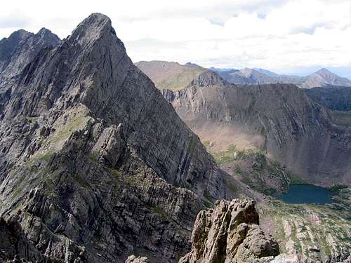
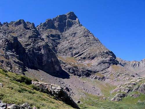
Crestone Needle and the upper South Colony Lake from Broken Hand Peak. August 21, 2004. Photo by Ryan Schilling
Located in the Rockies of southern Colorado, Crestone Needle is in the heart of the Sangre de Cristo (Blood of Christ) range. It ranks 20th in the state and is one of Colorado's 54 fourteen-thousand foot mountains. The Needle was first climbed by Albert Ellingwood and Eleanor Davis on July 24, 1916 via the Crestone Peak/Needle Traverse. Many a Colorado climber considers Crestone Needle to have a special place in his/her heart. This is an aesthetic and pleasingly challenging mountain that makes a climber's heart sing.
With the easiest route being Class 3, the mountain is considered one of the hardest 14ers to climb. The easiest route is the South Face, class 3, grade II, which is very popular, but can be challenging for the novice peakbagger. The Ellingwood Ledges/Arete route 5.7, grade III, is also popular due to the 1979 book Fifty Classic Climbs of North America by Steve Roper and Allen Steck. Regardless of the route, this mountain demands respect. Otherwise, this is a spectacular mountain and highly recommended for those seeking a challenge and real climbing adventure!
The Sangre de Cristo mountain range is a spectacular collection of peaks which stretches 250 miles from Santa Fe, New Mexico to Salida, Colorado. Please note the left side bar which features all the mountains in the Sangre de Cristos, both in Colorado and New Mexico.
Special Note: I have the honor of recently adopting this page from long-time SP member Alan Ellis. From a base in the US state of Oklahma, Alan has contributed much to the content and community of SummitPost. I have enjoyed the honor of climbing with Alan and his wife Jackie, and am proud to assume responsibility for this page. Climb on, Okies!
Getting There
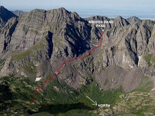
Photo and annotations by Alan Ellis
Crestone Needle is located in south central Colorado approximately 12 miles southwest of Westcliffe. There are several trailheads, the most popular being the South Colony Lakes trailhead on the east side of the range near Westcliffe. There is another trailhead on the west side of the range called Cottonwood Creek located on private property. Cottonwood Creek Trail is poorly maintained below the timberline -- it's very narrow with lots of downed trees. (Bob Webster 8-17-03) See Red Tape section for more Cottonwood Creek instructions.
From Westcliffe, Colorado: Drive southwest on highway 69 about 4.5 miles to Colfax Lane (CO119) where there is a Forest Service sign. Turn right (south) and go another 5.5 miles until the road ends, then turn right (going west) on South Colony Road (Forest Service Road 120) for 1.5 miles where there is a fairly large parking lot on the right. Low-clearance vehicles can park here but recent improvements in the road (July 2006) allow 2WD vehicles to continue for another 2.6 miles to a new gate and parking lot (30 vehicles) located approximately a half-mile past the Rainbow Trail marker at approximately 9900 ft. The road is closed at the gate and the parking lot. From the gate west of the Rainbow Trail, it is a 4.5 mile hike to South Colony basin. From the new gate, follow the old road for another 3.5 miles until the road turns into a trail. Upon arrival at lower South Colony lake, the trail forks and a small wooden sign (photo) will greet you. The sign says, "Crestone Needle Standard Route," with an arrow pointing to the left. Take the left fork to begin the approach to Broken Hand Pass. Take the right fork if looking for a campsite or if heading for the upper lake to do the Ellingwood Arete.
See the left side-bar for a list of summit routes which begin at lower South Colony Lake.
An option from the western side of the range is the Cottonwood Creek Trailhead near Crestone, Colorado. To find the trailhead, leave Colorado state highway 17, 0.5 miles south of Moffat and head straight east (Road T) toward the town of Crestone. Just prior to the road turning north (left) into Crestone, turn south (right) into the Baca Grande Chalets Grants subdivision (there is a large sign) and follow the Camino Baca Grande road as it initially curves left (paved then dirt) through the subdivision for about 5.4 miles. When the road ends at a “T” intersection, turn left, pass a large water tank (in 0.1 miles) on the right, before the road passes through an indistinct meadow (0.2 miles) with the unsigned trailhead on the left. Park in the few spaces on the right side of the road in this meadow and find the trailhead going into the trees and uphill initially on the north side of the meadow (left side of the road) prior to the trail heading up the valley along the north side of Cottonwood Creek. This trail is not in the best of shape and downed trees should be expected. The road crosses Cottonwood Creek shortly after passing through the meadow. If you cross the Creek, you have passed the trailhead. There is a Forest Service sign that addresses trail monitoring equipment just before the road crosses the Creek. The trail is not located anywhere near that sign. Do not pass over Cottonwood Creek and only park in the meadow since all the land along the road is private property. The landowner allows PARKING IN THE MEADOW ONLY. There is NO CAMPING at the trailhead parking area. (Directions courtesy of Dan Bereck)
Red Tape
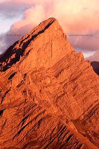
Photo ©2005 by Jack Brauer
Crestone Needle is located in the San Isabel National Forest inside the Sangre de Cristo Wilderness Area. No permits are required. Although the entire range, the mountain, and South Colony Lakes are in the wilderness area, the 4WD forest service road (FR120) is not. The Forest Service has created a three mile narrow non-wilderness corridor which takes you within two miles of South Colony Lakes. Rangers make daily drives up to the lakes area in the summer.
San Isabel National Forest, San Carlos Ranger District, 3170 E. Main, Canon City, CO 81212. Phone: (719) 269-8500, Fax: (719) 269-8719. Westcliffe has a small one-man ranger station: (719) 783-2079. The local ranger is currently Jeff Outhier.
Weather & Seasons | When To Climb
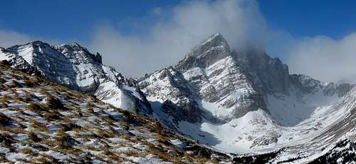
Crestone Needle in January 2009. Photo by shknbke
As with most Colorado high peaks, late June through mid September are best for summer season climbs. However, the mountain has also been climbed in the dead of winter by experienced winter mountaineers. September can be a wonderful time to climb. The weather settles as fall high pressure systems move through and provide several continuous days of cool, clear skies. Otherwise, violent afternoon thunderstorms are a daily occurance. Regardless of the route, start very early. Storms typically hit early afternoon and can last until after dark.
Northern Sangre de Cristo Mountains above 11000 Ft

Mountain Conditions
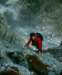
Photo by Mountain Jim
The rock on Crestone Needle is knobby conglomerate rock. These knobs are pretty solid but have been known to pull out.
As with any Colorado high peak, conditions can change from year to year depending on weather, snowfall, etc. Crestone Needle is known for rockfall, especially late in the day. A helmet is recommended for all routes.
The 400 ft couloir up the east side of Broken Hand Pass is a moderate snow slope which can linger until July. As the climbing season begins, climbers stomp steps into the slope, and people use the same steps over and over. However, in the morning, these steps and the entire slope are icy and treacherous. Later in the day the steps and the slope are slushy. Some carry an ice axe for self-arrest just for this section.
Crestone Needle Weather
Camping
Good camping can be found near South Colony Lakes. Photo by Sisyphus
Camping is allowed throughout the South Colony Lakes area. However, the Forest Service is now in the process of constructing designated campsites, so try to use one of those. No camping within 300 feet of the lakes. In addition, there are several new Forest Service camping sites along South Colony road. These sites are typically used by car campers, fishermen, etc. Camping is not allowed in the 1.5 miles between the 2WD parking lot and the Forest Service boundry.
There are several Forest Service campgrounds nearby. The closest is Alvarado, located on CO140, 5 miles west of highway 69, and one mile north of the Colfax Lane turnoff. Alvarado has 47 sites and can accomodate up to a 35 foot RV (no hookups). Alvarado is at 9000 ft which is a good place to spend the night and acclimate. Alvarado campground host: (719) 489-2744. There are other Forest Service campgrounds in the area. None have showers but most have rest rooms and drinking water. Call the Forest Service at (719) 269-8500 or (719) 783-2079 for more information on other FS campgrounds nearby.
Online Campground Guide
Grape Creek RV Park: 2 miles south of Westcliffe. (719) 783-2588.
Eberling Mobile Home and RV Park: In Silvercliff on the east side of Westcliffe. (719) 783-9778. Coin operated showers and laundromat.
Local Stuff
There are two other 14ers accessible from the South Colony Lakes area: Humboldt Peak 14,064, and Crestone Peak 14,294.
Westcliffe has a grocery store on the west end of town.
Pay showers and a laundromat are available at the Eberling Mobile Home and RV park in Silvercliff on the east side of Westcliffe.
More information on the area: Westcliffe Chamber of Commerce: Toll Free 1-877-793-3170.
Westcliffe has a grocery store on the west end of town.
Pay showers and a laundromat are available at the Eberling Mobile Home and RV park in Silvercliff on the east side of Westcliffe.
More information on the area: Westcliffe Chamber of Commerce: Toll Free 1-877-793-3170.
Maps
San Isabel National Forest Map
Crestone Peak USGS Quadrangle
Maps below are of the Crestone Needle/South Colony general area, approach, and routes.
Crestone Peak USGS Quadrangle
Maps below are of the Crestone Needle/South Colony general area, approach, and routes.
 |
 |
 |
External Links
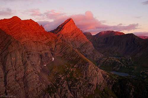
Photo ©2005 by Jack Brauer
- Alan Ellis' 2009 Climb of Ellingwood Arete
Trip report, photos, and video of a climb of Ellingwood Arete in July 2009. - Alan Ellis' 2001 Climb of Ellingwood Arete
Trip report and photos of a climb of Ellingwood Arete in July 2001. - Custer County (Westcliffe) website
Lists restaurants, lodging, shopping, activities, and events in the Custer County and Westcliffe area. - Customized Topographic Maps
National Geographic customized topos. Great maps which are waterproof and shaded relief. - Colorado Avalanche Information Center
- Weather: Zone Forcast for Crestone Area
Zone: Del Norte Vicinity - Sun/Moon Rise and Set Table
Cool site to figure sun/moon rise and set for any date or location in the U.S. - Customized Topos and more.
Customized topographic maps which are waterproof and shaded relief. Site also has guidebooks and other stuff. - Crestone Linkup
Great trip report of a one day ascent of Crestone Needle, Crestone Peak, Challenger Point, and Kit Carson. - Crestone Needle & Humboldt Peak
- Team Arp Climbs Ellingwood Ledges
- Crestone Needle - Pk. to Ndl. Traverse + (09/17/2005)
- 14ers.com - The Home of Colorado's Highest Peaks
Fourteener Photos, Route Descriptions, Forum, and more...
ARR - Jul 20, 2019 6:42 pm - Hasn't voted
Drive to upper parking lotIs approachable by 4wheel drive only. Yes, we made it in a Subaru Outback, but only because the weather was clear, the road was dry and the driver highly skilled.
Lelee1210 - Feb 16, 2023 5:39 am - Voted 10/10
Re: Drive to upper parking lotI agree