
-
 15713 Hits
-
 81.18% Score
-
 13 Votes
|
|
Mountain/Rock |
|---|---|
|
|
43.69720°N / 115.4987°W |
|
|
Boise |
|
|
Hiking, Scrambling |
|
|
Spring, Summer, Fall |
|
|
8148 ft / 2484 m |
|
|
Overview

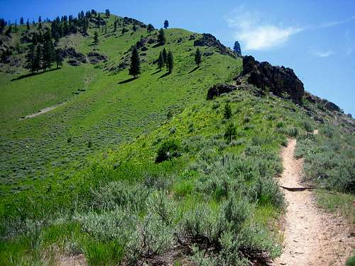
Sheep Mountain sits near some of the more noteworthy Boise Mountains. Visible from it's long broad saddle-like summit are Steele Mountain with it's technical climbs (a rarity in the area) and the majestic north side of Trinity Mountain. Trinity contains beautiful alpine lakes and is usually snow bound into July. In the distance are The Rakers and the west side of the Sawtooth Range. To the southeast is Two Point Mountain, the tallest in the Boise Mountains at 10124. It's the only peak that rises above the 10,000 foot mark in this range. Closer to Sheep Mountain are Rattlesnake Mountain and Lava Mountain. The William H. Pogue National Recreation Trail winds it way around the lower slopes of the region. The trail is named after a Fish & Game officer.
The Sheep Mountain summit contains two high points on each edge of the long broad ridge. The eastern summit is slightly higher, while the west summit contains the summit register. A very interesting rock outcropping is near the west summit and big snow drifts usually linger on the north sides. Despite it's National Recreation status, solitude is easily found in this area. A nice treat are the bridges that cross all the major creeks. These are rare in the Boise Mountains.
Routes
Sheep Mountain itself offers 3 interesting ways to summit.
Roaring River -Pogue Trail: From the major bend in the Roaring River Road, follow the mark trail south through a relatively lush river valley. After 2 miles, follow the Pogue Trail west to the marked junction for the summit. Follow switchbacks to the summit.
5.6 miles and 3696 feet elevation gain (one-way)
North Ridge Trail: 3.3 miles south of the Middle Fork of the Boise, on the Roaring River Road, take the signed trail steeply to the north ridge. Follow the ridge south with exceptional views as it gradually climbs to the summit. Snow lingers into May and June.
7.1 miles and 4278 feet elevation gain (one-way)
Northeast Snow climb: This early season snow climb follows the prominent couloir-like gulley on the northeast side of the peak. Follow the Roaring River Trail south for 1/3 of a mile. Cross the river (difficult) and follow the drainage west and steeply up. The slope is gulley-like and becomes steep under the summit. An ice-ax and cramp-ons may be required. Use the trails as your descent.
2.3 miles and 3263 feet elevation gain (one-way)
Road Approach

Road Approach
Take the Middle Fork of the Boise River Road off ID-21. Follow this past Arrowrock Dam, Twin Springs, and the North Fork junction for 51 miles on a windy, rutted, and narrow dirt road. Turn south on the signed Roaring River Road for 6 miles and park at the major bend in the road at the trailhead. Expect a 2-21/4 hour drive from Boise.
Weather Radar
