

-
 32355 Hits
-
 77.48% Score
-
 8 Votes
|
|
Mountain/Rock |
|---|---|
|
|
41.75775°N / 73.45661°W |
|
|
Litchfield |
|
|
Hiking, Trad Climbing, Toprope |
|
|
Spring, Summer, Fall, Winter |
|
|
950 ft / 290 m |
|
|
Overview
 Upper slabs
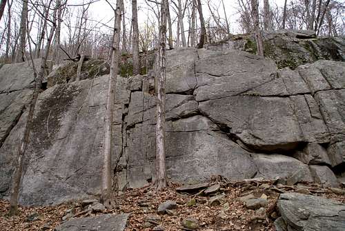 Lower wall
 Upper slabs
Named after Timothy St. Johns, who owned the property in the 1800's, Saint John's Ledges consists of two separate small, east-facing climbing areas located on the Appalachian Trail in Kent, Connecticut. This area, like most Connecticut areas, is mostly top-rope and traditional climbing.
Routes
Upper Climbing Area: Appearances being deceiving, this slabby face is over 100 feet tall in places. A 60m rope will help in roped descent, or a walk-off to the right once you reach the top. To set up on top, also approach from the right before reaching the cliff face. Continuing beyond the cliff and up the Appalachian Trail to the top will only put you way above the area you need to be. Right to left:Super Slab - 5.5-5.10 - TR, Large open slab on the right end, 100 feet high, with a horizontal crack running across at 15 feet up.Athlete's Feet - 5.10+ - Just to left of the 20-foot left-facing corner climb the smooth face past a former bolt to an overlap, then continue up the slab to the top.
Slickrock - 5.10+ - TR, 15 feet left of the former bolt of Athlete's Feet is a smooth face with a black streak 6 feet off the ground. Climb the black streak and pass it on the right, continuing straight up the face to the top.
Blisters - 5.7 - 50 feet from the first series of slabs is a steep crack with a small overlap and a left-facing inside corner. Climb the small corner, pull the overlap, and then follow the crack.
Trail Magic - 5.8+ - The most obvious line on the crag. 30 feet left of Blisters is a small overhang, about 15 feet up, with a crack running straight to the top. The crack becomes very thin before getting easier.Lower Climbing Area: a smaller and much shorter area than the upper, but of much higher quality. Most of the climbs here are 20-30 feet. Right to left:First Timer - 5.4 - 6 feet from the right edge of the cliff. Start at the short right-facing inside corner, and follow the crack for 15 feet to the top.
Fly - 5.9 - TR, An arm's length left from First Timer, follow a thin seam to a 3-inch crack at the top.
Try or Fly - 5.7 - Just left of Fly is a diagonal crack that goes left up a small ramp and continues to a dirty finger crack.
Try - 5.2 - 6 feet left of the diagonal crack is a large crack system that leads to the top.
Gumby to Greatness - 5.10 - TR, Just to the right of the lichen covered slab is a thin seam that starts halfway up. Climb the face to the seam and follow it all the way up.
Wilderness Crack - 5.3 - A large crack with a large boulder at the top.
The Graduate - 5.10 - 5 feet to the left of Wilderness Crack is a rectangular depression with a rock halfway up. Face climb to the depression and follow the thin seam and face moves to the top.
Workout in the Woods - 5.6 - 6 feet to the left of the Graduate, and just to the right of the overhang, is a thin seam that widens to 6 inches with a tree in the middle of it.
Directions
 Upper slab crack
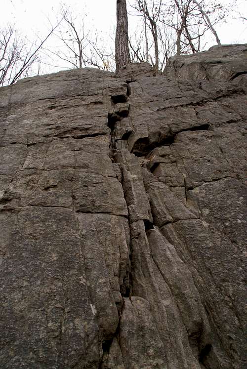 Lower wall
From Kent center, at the monument in the middle of the intersection of Routes 7 and 341, head west on Route 341 past the Dodge dealership and over the bridge. Immediately after the bridge make a right onto Skiff Mountain Road. After about a mile bear right onto a dirt road, River Road. This road is not maintained in the winter and may be impassable after a good storm. You will pass numerous pull-offs for 1.6 miles until you reach the correct parking area, on the left. Follow the white-blazed Appalachian Trail uphill from parking area. To reach the lower climbing area look for a faint trail, on the left, 35 feet past the trail map box. To reach the upper climbing area, stay on the Appalachian Trail until it passes directly by the bottom of the cliff band.
Weather

cliff_hanger - Jan 12, 2007 10:57 pm - Hasn't voted
St. John's LowerBack in the 1980's there was a climbing shop around Hartford called "Clapp & Treat". This shop had a "new route book" and the text below shows St. John's Ledges routes that I copied form that book: Lower Cliff Area Little Jewel 5.10 ** FA: Ken Nichols 8/85 Start at the clean face midway bewteen two easy crack systems. Face climb up to the thin straight seam that leads to the top. The seam can be protected with a #3 stopper. Looks like this is sometims called "The Graduate" Triple X 5.10 FA: Alex Catlin, Scott Morse Deft layback moves lead up the face exactly midway between "Little Jewel and the step and staircase of "Easy Route" When I get a chance, I'll post descriptions for "Meteor Shower", "Arch of Delight", "Lone Rino", "13th dwarf", "Dwarf Nebula", "Cheetah Wheelie" and "On Edge" on the upper slabs.
cliff_hanger - Jan 12, 2007 11:23 pm - Hasn't voted
St Johns UpperCopied form the Clapp & Treat "New Route Book" in the mid-1980's Upper Slab Area Meteor Shower 5.9+ FA: Steve Chase (Toprope) 8/85 Near the left end of the main slab is a very thin 20-25' slab Unnamed 5.6 ** FA: Bob Clark, Chad Hussey, Steve Williard, Rick Palm 5/85 The first obvious crack right of the hollow flake. Clean and attractive. Follow it to the hollow flake, step left and finish up the same beautiful face found on "Hollow Flake". The upper face is poorly protected. Arch of Delight 5.6 ** FA: Bill Ferruci 9/84 The large arch facing left on the left side of the slabs. Start on the face and cruise up the dorner. Good moves take you up the overlap. Lone Rino 5.5 ** FA: Stew Sayah, Steve Chase 9/85 Follow the first major crack system on the upper band. 13th Dwarf 5.5 ** FA: Peter Wallace, Steve Chase 5/85 Follow the second major crack system (from the left) Dwarf Nebula 5.9- ** FA: Phil Knight, Steve Chase, Tim Glover Start at 13th Dwarf, move left to the face at the "false ledge". Follow thin face moves up to a small horizontal crack/ledge and finish up right. Fair pro. Direct Start 5.9 ** FA: Dean Levesque Climb the face to the left of the 13th Dwarf crack Cheetah Wheelie 5.6 ** FA: Stew Sayah, Steve Chase Clib the obvious dike 100 feet right of 13th Dwarf. Climb up 15 feet, step left to some high steps. Move right to a tree. Follow the crack to the top. On Edge 5.6 ** FA: Bill Ferrucci, Dean Levesque Climb the arete on the right side of the "EMC" wall. Pig Mine 5.7 * FA: Bill ferrucci, Dean Levesque 5/86 Clib the crack 15' right of 13th Dwarf ST. Steven 5.9 *** FA: Dean Levesque, Bill Ferrucci Start at the obvious scooped headwall. Climb straight up. Sustained. Tombstone blues 5.5-5.6 Cruise up the corned and face to the right of On Edge. Pull up over the white, loose "Tombstone". Baby Snakes 5.8 FA: Dean Levesque, Bill Ferrucci 6/86 Climb the face just to the left of On Edge
Uni1820 - Jun 23, 2008 8:21 pm - Hasn't voted
EMC WallThe "Upper Slabs" routes described from the Clapp & Treat route book is actually called the Excentric Mountaineers Wall (EMC Wall) which can be found about a ten minute walk south of the top of the primary Upper Slab area. We cleaned these routes in 1985, and found them to be enjoyable, generally high quality, albiet tough to get to routes, that are well worth the effort of bushwacking to them. Check them out.