
-
 20200 Hits
-
 85.21% Score
-
 20 Votes
|
|
Mountain/Rock |
|---|---|
|
|
44.16160°N / 115.02353°W |
|
|
Custer |
|
|
Hiking, Mountaineering, Trad Climbing, Aid Climbing, Mixed, Scrambling |
|
|
Summer, Fall |
|
|
10312 ft / 3143 m |
|
|
Overview

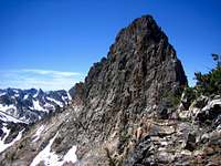
Merritt Peak stands tall above Goat Lake and is one of the most challenging non technical peaks in the entire range. The massive mountain is comprised of three summits on a serrated ridgeline perched above steep snowy slopes that slide down into permanent snow fields and hidden alpine lakes. The middle summit is the true high point and requires some airy Class 4 moves over mostly solid rock to reach the summit. The lower north summit is a broad area with great views of Goat Lake below and can be reached easily via Class 3 from the North-Middle saddle. The intriguing south summit looms large above the gray dike and much of the climbing below in the snow bowl at 9500 feet. Little is known about routes on the south and there is no documentation at this point.
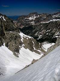
Goat Lake below Merritt Peak is one of the largest and most scenic lakes in the entire range. No official trail exists to Goat Lake, but a rugged climbers path brings many backpackers, fisherman and explorers to the waters edge. Like Sawtooth Lake and Baron Lake, Goat Lake is often a destination in itself with a towering mountain sitting directly above a portion of the lake. Those willing to explore the upper chain lakes that sit above and south of Goat Lake are rewarded with even more stunning scenery. Some of the Sawtooth Range's biggest permanent snow fields exist in this area, and for those scrambling up the peaks like Merritt, they offer quick and firm methods of travel.

Merritt Peak is flanked on it's eastern and southern side by Crown Point, Williams Peak, and Thompson Peak (the high point of the Sawtooth Range). On it's west side is Alpine Peak and Mt. Regan. Merritt offers a more challenging climb than any of these neighboring peaks, but because the name is a local one and not official, very few people see the true knife serrated summit. A summit register was placed on the Middle Summit (true high point) in June of 2007.
Routes

South Ridge (Class 4)- from the lake just
southwest of Lake 8865, follow a thin snow couloir (or a thin, steep stream later
on) west into a massive hidden snow bowl containing permanent snow fields and a
long lasting frozen lake. From the scenic snow bowl, scramble north toward a
prominent gray dike cutting across the upper slopes. The scrambling is
Class 3+ here to reach above the dike, but given some loose rock, the going can
be challenging. Find a slot above the gray dike to reach the summit ridge
between the South Summit and Middle Summit. Bypass a vertical ridgeline tower on
the northwest side and find a steep, loose chute that goes toward the saddle
between the North Summit and the Middle Summit.
From the Iron Creek Parking Area: 13.6 miles and 4867 feet gain (one way)
South Ridge / SE Face (Class 4)- follow the directions above to the snow bowl, then climb directly north on the east ridge toward the a gray dike (different than the above mentioned dike). Follow this dike just under and to the east of the Middle summit. Leave the gray dike and climb steeply up snow toward the northwest to the North-Middle Saddle.
From the Iron Creek Parking Area: 12.9 miles and 4646 feet gain (one way)
Northeast Snow Climb (Class 4)- follow the prominent and year round snow field on the SW side of Goat Lake as it climbs steeply to a point just north of the North Summit.
From the Iron Creek Parking Area: 10.8 miles and 4640 feet gain (one way)
Getting There
From the Iron Creek Trailhead, follow the Alpine Way Trail as it junctions off and to the south. The trail climbs steeply at first, then levels out as it bypasses Goat Buttress. Just before the trail drops into the lower Goat Creek drainage, follow a very prominent climbers trail steeply up to the east side of Goat Lake. To reach the chain lakes south of Goat Lake, either traverse closely along the east side of the lake, or obtain the prominent ridge toward Point 9088
Road Approach
Take the Iron Creek dirt road just west of Stanley, Idaho off of ID-21.
The dirt road is passable by any vehicle.
The approach roads are closed until May usually even if snow doesn't exist.
Check the road conditions at: Idaho Transportation Department
Conditions and Season

Conditions may vary greatly. Access is typically from May to October.
The Sawtooths can be the coldest region in the lower 48 during the winter. Summertime is usually warmest in June and July, but the nights are usually cool. The days can still get very warm and often long periods of dry weather occur. Lightning sparked forest fires occur nearly every year on the lower slopes and the nearby regions of the Frank Church River of No Return Wilderness, White Clouds, and Boise Mountains.
By August the nights can get cold, although the days are still usually dry. Winter comes as early as October, or as late as December. Approach roads usually don't open until May, but you can still ski the approach roads during the winter. Winter ascents are rare. Nearby Stanley, Idaho Climate Data:
| Jan | Feb | Mar | Apr | May | Jun | Jul | Aug | Sep | Oct | Nov | Dec | Annual | |
| Average Max. Temperature (F) | 27.0 | 33.7 | 42.5 | 50.3 | 59.9 | 68.4 | 78.7 | 78.4 | 68.6 | 56.6 | 38.1 | 26.0 | 52.4 |
| Average Min. Temperature (F) | -0.5 | 0.3 | 9.7 | 20.3 | 28.3 | 33.9 | 36.0 | 34.0 | 27.2 | 20.6 | 12.0 | -0.8 | 18.4 |
| Average Total Precipitation (in.) | 1.64 | 1.33 | 1.02 | 1.02 | 1.17 | 1.16 | 0.59 | 0.59 | 0.78 | 0.92 | 1.46 | 1.55 | 13.24 |
| Average Total SnowFall (in.) | 16.9 | 13.2 | 10.2 | 3.4 | 0.9 | 0.2 | 0.0 | 0.0 | 0.4 | 1.7 | 10.4 | 14.6 | 71.9 |
| Average Snow Depth (in.) | 18 | 20 | 15 | 6 | 0 | 0 | 0 | 0 | 0 | 0 | 2 | 8 | 6 |
[img:203437:alignleft:small:]
Latest Avalanche Report (Sawtooth Area)
National Weather Service Current Forecast for Stanley
SNOTEL-gives latest snow depth readings
Sawtooth National Recreation Area