
-
 24694 Hits
-
 88.61% Score
-
 27 Votes
|
|
Mountain/Rock |
|---|---|
|
|
16.4469°S / 71.2394°W |
|
|
Mountaineering |
|
|
Spring, Summer, Fall, Winter |
|
|
18488 ft / 5635 m |
|
|
Overview
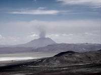 A View of Ubinas
The Pichu Pichu group is a very eroded volcano with 7 summits, the highest of which is 5635m (18,488'). It is part of Cordillera Volcánica, which also includes the Chachani group, El Misti and the Ubinas group. Pichu Pichu is a crescent shaped mountain east of the city of Arequipa. It is about 12 miles long, running generally north and south, with a westward tilt on the north end. It is about 4 ½ miles from Laguna Salinas at the closest point. To the east and slightly north, across Laguna Salinas, is Volcán Ubinas, the most active volcano in Peru (right Scott?). From the summit there are great views of El Misti and Chachani, as well as Ubinas, which was still erupting when we were there.
An archaeological party made the first modern ascent of Pichu Pichu in 1959, according to Jill Neate, "Mountaineering in the Andes" (1994). Archaeological remains were found near the summit.
Getting There
 Going by El Misti
 Turn Right Here for Pichu Pichu
 Turn Here for Pichu Pichu and Ubinas
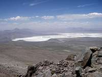 Laguana Salinas (Dry)
To get to Pichu Pichu by car, take the old road from Arequipa to Puno, which goes through Chiguata, past El Misti and around on the west and north side of Pichu Pichu. The pavement ends at Chiguata, and from there it is a rough gravel/dirt road that climbs up and around Pichu Pichu. As you start nearing the highest point on the north end of the mountain, the road goes through a narrow tunnel. Just before arriving at Laguna Salinas there is a large information sign on the left side of the road. Right before that is a small road going off to the right, with a sign saying "Inkabor", which goes around the southeast of the lake, to near Ubinas (this is the road you want). As in many places, there are multiple tracks here, some of them even going through the lakebed during the dry season. A 4x4 isn’t necessary, at least during the dry season, but a higher clearance vehicle is good.
From this road, you can see which is the highest peak on Pichu Pichu. One explanation said to aim for the center peak and then traverse along the ridge to the left (south) until you reach the summit. There are supposed to be ruins on the center peak, and a path from there going to the summit. To reach this point, turn right at a faint jeep trail before the lake and follow it as far as it goes, at the base of the mountain. We continued driving around the lake until we came to a road going off to the right, which goes between Pichu Pichu and the peak to the south. At the point where we seemed to be closest to the main ridge running up to the south peak, we parked the car (about 14,900'), which was about 3 hours drive from Arequipa. The jeep trail above appears to be a better route, we later drove to the end of it, but haven't yet hiked from there.
There is also a public bus which departs from calle (street) Espinar in the district of Mira Flores. Take the bus going to Comunidad Paramayo, which leaves at 7:00 am. The cost in December of 2007 was 10 soles, and takes about 5 hours. This is the starting point for climbing Ubinas. For Pichu Pichu, get off earlier, when it looks like you are at the closest point to the true summit. The return bus leaves Paramayo at 9:30 am. There is only 1 bus each day so if you can’t make it back to the road to catch the bus in the morning, you may have to wait until the following day. There is a surprising amount of truck traffic on the road, it may be possible to catch a ride with one of them.
The Climb
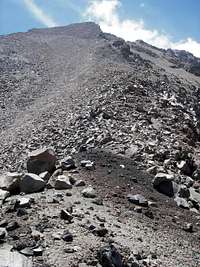 Final Climb to the Peak
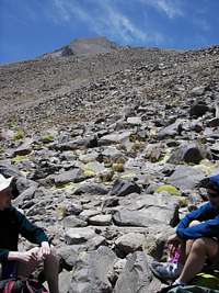 Taking a Break on the Ridge Climb
 Some Scrambling Required
 Summit Cross
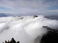 Lower Peaks in the Clouds
From where we parked the car along the jeep road, we climbed up the ridge to the first peak, and then we traversed to the north to the true summit. It was a poor route in places, with some 3rd / 4th class scrambling, but we made it to the summit with little problem, mainly keeping to the ridge but dropping down in a few places. My GPS showed 18,610’ on the summit. There is an old metal cross on the summit, which has as a plaque saying it was placed there in 1964 by a mountaineering club. It is now bent over flat to the ground.
What appears to be a better route is to go past the first ridge to another large ridge going up to the true summit, (unless there are some hidden problems there). See the driving directions for the center peak above. We came down the gully between the two ridges, which was steep but fairly easy. The first part was fast coming down the scree, then a lot of boulder hopping and rough cross-country back to the car. Round trip time on our route was 8 ½ hours. I’m not sure if there are any routes up the west side of the mountain, but it would seem that there must be. It would be a lot shorter drive in this case, but probably a longer approach to the summit.