
-
 21117 Hits
-
 87.31% Score
-
 24 Votes
|
|
Mountain/Rock |
|---|---|
|
|
45.48000°N / 113.76°W |
|
|
Lemhi, Beaverhead |
|
|
Hiking, Bouldering, Scrambling |
|
|
Summer, Fall |
|
|
9858 ft / 3005 m |
|
|
Overview
Sheep Mountain lays claim to being the northernmost alpine summit in the Beaverheads.At 9858' it is the highest peak in a small neighborhood group of five 9000' summits.
These include Jumbo Mountain 9723', Peak 9681, Peak 9646, and Pyramid Peak 9616'.
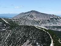
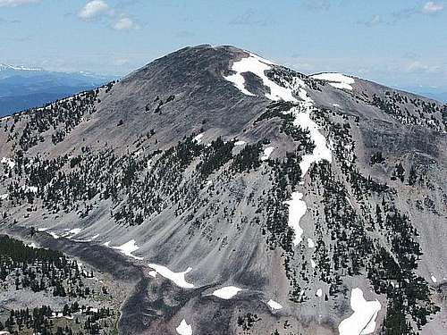
Most view this mountain while traveling through Montana's Big Hole Valley. From that vantage point it can be accurately described as plain and featureless, especially when compared to its more stately Beaverhead cousins. Sheep Mountain's best profile is seen from the south, but a backcountry perspective is needed to see it.
 Ovis Lake
Sheep Mountain does have some character despite its plain features. Ovis Lake with its symmetrical lines and rich coloring occupies the east side basin. In addition, an old wide mouth glass jar serves as a summit register. 1960's era USFS maps along with 60's signatures occupy the jar. A little muscle and some leverage is needed to get at the contents.
Lopez' Idaho A Climbing Guide states that T.M. Bannon used this peak for a triangulation station in 1913. There is an iron boundary marker down the north ridge which means the state surveyors crew beat Bannon to the summit by 7 to 9 years.
Sheep Mountain can be approached from either Idaho or Montana and the route choices will be covered in the Getting There and Summit Routes sections. The approach and route information corresponds alphabetically.
While Sheep Mountain may not be the number one choice for a summit destination in the Beaverheads,
it still has the excellent views and alpine environment that most of us cannot get enough of.
Getting There
IdahoAPPROACH A
From US 93 turn at Gibbonsville and head east through town and travel up to Big Hole Pass.
APPROACH B
From US 93 turn at mile marker 321 onto Fourth of July Creek Road which is located about 6 miles south of North Fork.
Travel 10.5 miles and take an obvious right turn at the 7520' spot elevation which is shown on the topo maps. Travel just under 1 mile and park at the fork below the steep kick up. The trailhead starts here and begins as the jeep trail that goes off to your left.
 Sheep Mountain
Montana
APPROACH C
From Hwy 43 west of Wisdom, turn on to the Gibbonsville road and head west for Big Hole Pass. Continue until you reach the several hundred acre Isaac Meadows which lies beyond the last private ranch and is marked by some crisscross wooden post fencing running north and south. Topozone does show Isaac Meadows as a topographic feature.
APPROACH D
Take the Twin Lakes campground exit which is 6.6 miles south of Wisdom on Hwy 278. Travel 8.2 miles at which point you will reach a log arch that says Sunnyslope on it. Proceed under the log arch which the Wisdom Ranger District has told me is public access.
I have not traveled beyond this point and some trial and error may be involved. Moose Creek Road may be your best approach.
Summit Routes
This is not going to be a step-by-step description on how to reach the summit, which I suspect most prefer anyway.Some general route descriptions will be given and then the adventure will be in your hands. All routes are Class 2 or 3.
Idaho
 Continental Divide route
ROUTE A
From the description in Lopez' book, this route follows the Continental Divide south to the summit of Sheep Mountain starting at Big Hole Pass. A 10 mile round trip is indicated.
ROUTE B
Start your hike on the jeep trail which will lead you to the Continental Divide Trail. Leave the CDT at a point of your choosing and aim for the saddle between Pyramid Peak and Peak 9681.
Once at the saddle, hike to the summit of Pyramid Peak and then continue north along the divide to Sheep Mountain. Round trip distance is roughly 10 miles.
Montana
 Isaac Meadows route
ROUTE C
Start at Isaac Meadows and expect the majority of your route to be a forested traverse all the way to tree line. Sound navigation skills, common sense, and a GPS can make this a success. This is the route I took. Expect a 10 mile round trip.
ROUTE D
Once you drive beyond the Sunnyslope log arch it is most likely trial and error time to pick out the best starting point. If you can access Moose Creek Road, this will probably be the shortest route.
Bannon Biography
 Bell Mountain
I want to acknowledge and give full credit to Rick Baugher and his contribution in Lopez's book which is my sole source for the following information on T.M. Bannon.
My purpose for including a short biography on Bannon is for those of you who live outside of Idaho and thus may not have a reason to own a copy of Lopez' book. I found Bannon to be an interesting and inspiring character.
Thomas M. Bannon worked for the United States Geologic Survey as a topographical engineer from 1889 to 1917. During this time as a surveyor he climbed nearly one thousand summits throughout the western United States.
 Borah Peak
Over two hundred of these summits were in Idaho and it is believed that over one hundred of these were most likely first ascents. Bannon's list of first ascents includes some of Idaho's most recognizable mountains. These include Bell Mountain, Borah Peak, Castle Peak, Diamond Peak, Leatherman Peak, Lem Peak, Mount McCaleb, and Standhope Peak.
Despite Bannon's obscurity, he was certainly an Idaho pioneer and a guy with plenty of 'the right stuff'.


Photo credits: Biglost, brendon, IdahoKid, Super Dave
Elevation, Contours, Etc.
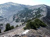
 North ridge boundary marker
After further review . . . there are two contour lines above the 9800' contour.
Obviously, this would put the elevation at 9880'+.
Sheep Mountain does have two rounded summits with the one to the southwest clearly higher. Both are very close to each other with a small gap separating the two. The summit cairn is located on the southwest one as well.
Are both summits above the 9880' contour, or is the higher southwest summit located where the triangle is shown on your topo map? To my discredit, I don't remember seeing the benchmark or recall the elevation on my GPS.
Maybe the gap between the two summits is 9858'. Who knows?
Since all three maps that I reviewed, along with Lopez' guide list the elevation at 9858', I will leave that as the official height for the sake of continuity. In the end though, each person certainly has the freedom to reach their own conclusion on the correct elevation.
Although a detail oriented person myself, one might say: "It is more about the experience, than the details".
Camping
IdahoTwin Creek campground administered by the USFS is located on US 93 about 15 miles north of Gibbonsville.
The privately owned Wagonhammer Campground is located on US 93 about 3 miles south of North Fork.
There is a small store and recently remodeled restroom and shower facility which is first rate.
Lost Trail Pass on the Idaho/Montana border (junction of US 93 and Hwy 43) has a seasonal visitor center, interpretive displays, and separate rest room facility. The rest room is heated and has hot water.
There is plenty of parking if you choose to car camp overnight. Closed in the winter months.
Montana
May Creek campground administered by the USFS is located on Hwy 43 about 9 miles east of Lost Trail Pass.
The city of Wisdom has a campground located on the west side of town. It has grassy sites, picnic tables, and restroom.
 Sheep Mountain
Area Administrators
North Fork Ranger District11 Casey Rd.
PO Box 180 Hwy 93 North
North Fork, Idaho 83466
208-865-2700
Wisdom Ranger District
PO Box 238
Wisdom, Montana 59761
406-689-3243