
-
 6322 Hits
-
 91.75% Score
-
 36 Votes
|
|
Mountain/Rock |
|---|---|
|
|
45.55605°N / 7.60576°E |
|
|
Hiking |
|
|
Spring, Summer, Fall |
|
|
9042 ft / 2756 m |
|
|
Overview
Easily recognizable from Canavese, the northern district of Torino province, it is one of the main summits of the Graian Pre-Alps.Also thanks to its pyramidal and majestic aspect, if seen from south, it is considered as the “monarch” of Valchiusella, where its south side slopes down. Its summit is the conjunction of three valleys: Valchiusella that flows in the Plain of Canavese; Soana Valley, a lateral valley of Orco Valley; Valle della Legna (wood valley), a lateral valley of Champorcher Valley.
It can be climbed without difficulties on each side. The view from its summit ranges from Ligurian Apennines to Pennine Alps.
  |
Monte Marzo
Getting There
By carFrom Torino to Soana Valley: Road “S.S.460” towards Cuorgnè and Ceresole Reale as far as Pont Canavese, turn right and drive along Soana Valley as far as Ronco Canavese, then follow the signs to Piamprato.
From Torino to Valchiusella: Highway A5, take exit “Ivrea” and follow the road towards Valchiusella; and drive along the valley as far as Fondo at the end of the paved road.
From Torino/Milano to Champorcher Valley: Highway A5 direction Aosta, take exit “Pont S. Martin” drive towards Aosta as far as Bard, turn left and drive along Champorcher Valley as far as Mellier, then turn left and park the car where the road ends in corrispondence of the small village of Outre l’Eve.
From Aosta to Champorcher Valley: Highway A5 direction Torino-Milano, take exit “Verres” drive towards Torino as far as Bard, then follow the previous itinerary.
By bus
Valchiusella approach: GTT has a bus service from Ivrea to Traversella
Soana Valley approach: GTT connect Pont Canavese to Piamprato
Champorcher Valley approach: VITA reaches Champorcher from Hone.
Nearest Airports: Milan Malpensa 140 km; Turin Caselle 75 km; Geneve (CH) 195 km
Routes overview
Normal route from ValchiusellaHeight difference: 1682m; 5-6 hours
The route starts from the end of the paved road, at Fondo (1074m) in correspondence of an ancient roman bridge, walk along the length of the valley, crossing the small village of Tallorno (1223m) then Alpe Prà (1550m) and Alpe Orti (2154m) up to “Colle degli Orti” pass (2634m). From here, a ridge with easy rock steps leads to the summit. Route marked with red paint.
Normal route from Valle Soana
Height difference: 1205m; 3-4 hours
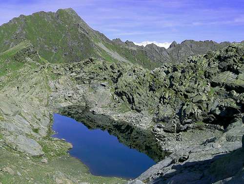
Park the car in front of the church of Piamprato (1551m), walk along the main street and turn right on the footpath towards Lago Santanel, marked with red paint. Follow the footpath up to Grangia Santanel (1981m), then turn right and walk out on the footpath, go up to a steep slope and reach a nice place called “Lago Morto” (2252m). From here follow the several cairns that indicate the way to the summit.
Normal route from Valle di Champorcher
Height difference: 1503m; 4-5 hours
The route starts from the small village of Outre l’Eve (1223m) on a large trail that cover entirely a pitoresque valley called Valle della Legna (or Leigne); thanks to the forests of larches and the presence of many maples, a walk in autumn in this valley, is an immersion in amazing colours.
The trail road to Alpe Porte (1341m) then, at a fork, take the footpath to the left, get Alpe Ourty (1527m) and, when it become a track, it borders some small lakes called Laghetti gelati (2434m). From here the summit is well visible in front of you and can be reached easily on uncertain track.

Colours of Valle della Legna
When To Climb
From June to November; usually autumn is more dry so it’s recommended.Where to stay
Posto tappa GTA Succinto (2Km far from Fondo) Tel. 0125.749080
Succinto
Bed & Breakfast "La Traleua" Traversella tel. 0125-749087
Posto tappa GTA Piamprato Tel. 0124.812926
Hotels and Campings in Champorcher Valley. For info Tourist Office Tel 0125 37134 - Fax 0125 37134 or www.regione.vda.it
Red tape
No restriction at all: Monte Marzo is very near but outside the borders of the Gran Paradiso National Park.Camping is allowed only above 2500 meters from sunset till dawn.
Books and Maps
Books:Valchiusella a piedi - Matteo Antonicelli
Maps:
IGC 1/50000 Ivrea Biella Bassa Valle d’Aosta
Comunità Montana Monte Rosa 1/50000
Mountain conditions
Weather forecasts:Piemonte and Valle d’Aosta Weather
Piemonte Weather and Snow conditions
Webcams of Soana Valley
Avalanches bulletins