
-
 14644 Hits
-
 93.35% Score
-
 42 Votes
|
|
Mountain/Rock |
|---|---|
|
|
45.51510°N / 7.27338°E |
|
|
Mountaineering |
|
|
12775 ft / 3894 m |
|
|
Overview
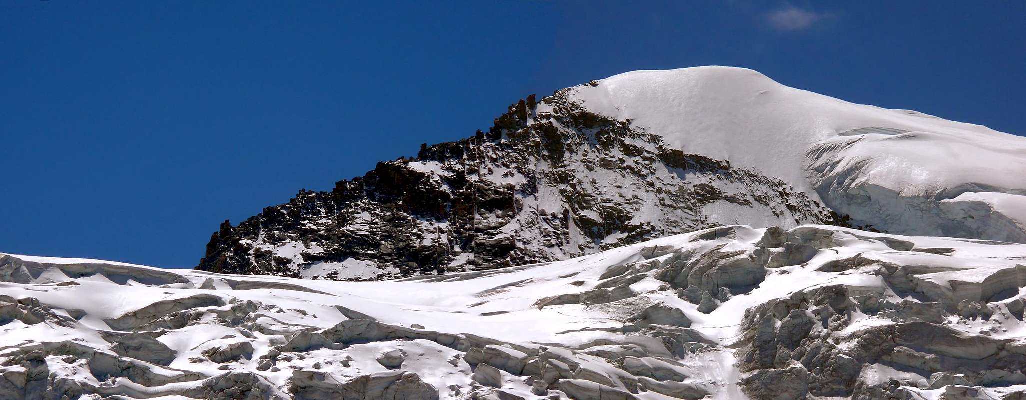
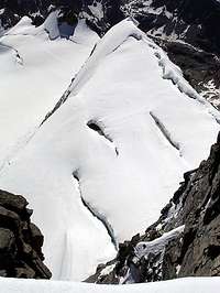
Cresta Gastaldi (Gastaldi Ridge) is a beautiful, imposing peak shaped like a gigantic triangle. It is the fifth highest Summit in the Gran Paradiso Group, and would certainly draw more attention if it were not surpassed by the nearby main top of Gran Paradiso (4.061m). Cresta Gastaldi is flanked by Colle Chamonin (3.698m) and Punta di Ceresole (3.777m) to the East and by Colle dell'Abeille (3.873m) and by the Roc (4.026m) to the West. The South Face almost overhanging, rises over the Noaschetta Glacier, while the Northern aspect is almost entirely covered by the huge Tribolazione Glacier. The mountain is clearly recognizable from Gimillan (1.787m), near Cogne, but it is hardly visible from downtown Cogne (1.534m), on the valley floor. The name of the peak was proposed by geologist Martino Baretti to honor Bartolomeo Gastaldi (Torino, 1818-1879), a valiant alpinist, who was founder and president of C.A.I. (the Italian Alpine Club). Baretti proposal was supported by the first ascent party, composed of W. Coolidge, G. Yeld, Christian Junior and R. Almer (1888).
 |
 |
 |
 |
 |
La Cresta Gastaldi è una bella, imponente sommità a forma di gigantesco triangolo. Risulta come la quinta Cima più alta del Gruppo del Gran Paradiso, e sicuramente attrarrebbe maggior attenzione se non fosse "oscurata" dalla vicina Vetta principale del Gran Paradiso (4.061 m). Viene affiancata dal Colle Chamonin (3.698 m) e dalla Punta di Ceresole (3.777 m) ad Oriente e dal Colle dell'Abeille (3.873 m; Ape) e dal Roc del Gran Paradiso (4.026 m) subito ad Ovest. La Parete Sud, quasi a strapiombo, s'innalza sul Ghiacciaio di Noaschetta, mentre la facciata della Nord è quasi interamente ricoperta dal grande ghiacciaio della Tribolazione. La montagna è chiaramente riconoscibile dal Villaggio di Gimillan (1.787 m), nei pressi e poco al di sopra di Cogne, ma è difficilmente visibile dal centro del medesimo Comune (1.534 m), sito nel fondovalle. Il nome gli è stato proposto dal famoso Geologo Martino Baretti onde onorare Bartolomeo Gastaldi (Torino, 1818-1879), alpinista coraggioso nonchè fondatore e Presidente del C.A.I. (Club Alpino Italiano). Tale poposta è stato suffragata dai primi salitori ovvero W. Coolidge, G. Resa, Christian Junior e R. Almer (1888).
First Ascents
- W Ridge: G.Yeld, W. Coolidge, Christian Junior and R. Almer, (Aug 12th, 1888).
- E-SE Ridge: C. Cookson, F. Truffer and L. Jantet, (Aug 22th, 1894).
- S Wall: T. Somervel, H. Symons and O. Thornycroft, (Jul 21th, 1921).
 |
 |
 |
 |
 |
Getting There
BY CAR:
- From Torino, Milano, etc: Motorway A5. Exit at Aosta Ovest. Drive to the near Aymavilles. Follow the directions for Valle di Cogne.
- From Switzerland: through the Grand Saint Bernard Tunnel or the namesake pass. Drive to Aosta, then follow the direction for Courmayeur on SS.26. Just after Sarre, turn to the left, in the direction of Valle di Cogne.
- From France: through Mont Blanc Tunnel or Petit Saint Bernard Pass. It isn't necessary to take Motorway A5: you can drive on SS.26, in the direction of Aosta. Before arriving at the Village of Sarre, turn right following the sign for Valle di Cogne. After Aymavilles, the SR.47 crosses the Villages of Vieyes, Epinel and Cretaz and after about 25 Km arrives at Cogne (1.534m). From Cogne you can get the Village of Valnontey (1.666m).
BY PLANE:
- Aeroporto "Corrado Gex" Saint Christophe (Aosta).
Route
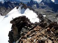
First day: From Cogne (1.534m) by bus or car to Valnontey (1.666m). Cars can be parked in the large square near the center of the village. Start the ascent of the Valnontey Valley on its orographic right side (climber's left). Go past the pleasant Pastures of Valmiana (1.728m) and reach the Erfaulet Bridge (1.830m); cross it and continue along the trail to a fork (2.040m, 1h'15/1h'30), where you take the left branch. Follow the right bank of the stream and head for the moraine called "Barma des Bouquetins" (2.698m). Climb the morain's ridge in its entirety reaching a hump. Follow this relief to a large snowfield, at the end of which you can discern a ledge going left. Climb on a faint, exposed trail for the entire length of the ledge; turn right and reach a small hanging valley. Head for the opposite side, and climb to a glacial dell between two spurs, cross it in the direction of a distinct rock gully. Climb the gully with circumspection, for the rocks are often covered with verglas and gravel. Past the gully, you'll get to the top of the spur where two fixed bivouacs are located: C. Pol (3.183m, sleeps 6) and M. Gérard - E. Grappein (3.200m, sleeps 9) (5h'30/6h'30 from Valnontey).
Prima giornata: da Cogne (1.534 m), tramite l'autobus o in auto a Valnontey (1.666 m). i mezzi posson essere parcheggiati nel piazzale vicino al centro del paese. Iniziare la salita della Valnontey sul lato orografico destro (a sinistra di chi sale). Si superano i piacevoli Pascoli diValmiana (1.728 m) raggiungendo il Ponte dell'Erfaulet (1.830 m); attraversarlo e proseguire lungo il sentiero fino ad un bivio (2.040 m, 1h'15 / 1h'30), ove si prende il ramo di sinistra. Seguire la sponda destra del torrente e la testa per la morena detta "Barma des Bouquetins" (2.698 m). risalire totalmente la cresta della morena raggiungendo una gobba. Seguire questo rilievo insino ad un grande nevaio, al termine del quale si può scorgere una sporgenza sulla sinistra. Salire su una debole traccia con percorso esposto per tutta la lunghezza della sporgenza; girare a destra raggiungendo un vallocello sospeso. Riprendere per il lato opposto, e salire ad una sella glaciale tra due speroni rocciosi, attraversando in seguito in direzione d'un ben distinguibile canalone di roccia. Salire la gola con prudenza, poiché le rocce sono spesso ricoperte da "verglass" e ghiaiioni. superato il canalone, s'arriva al vertice dello sperone, dove si trovano due bivacchi fissi: Carlo Pol (3.183 m, 6 posti letto) e Marcello Gérard - Ettore Grappein (3.200 m, 9 posti letto) (5h'30 / 6h'30 da Valnontey).
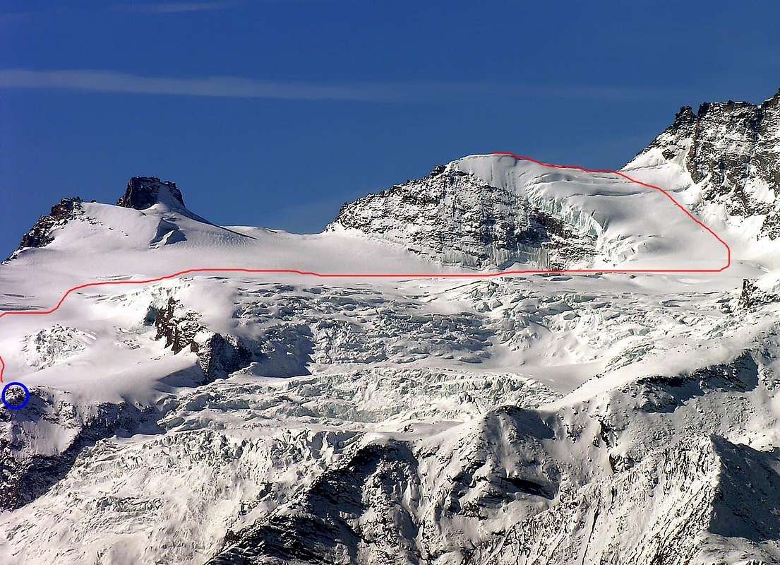
Second day: Go toward the cliff directly behind the two bivouacs for about one hundred meters, then turn left (beware of crevasses) aiming for Colle della Luna. (On the left one can admire the great seracs coming down from Testa della Tribolazione.) Skirt the large crevasses and continue past Punta di Ceresole, cross a large glacial valley and aiming for the large East Face of Gran Paradiso. Turn left when you are almost under the face and start climbing the glacier on the Northwest side of Cresta Gastaldi (watch out for the crevasses). Keep at a safe distance from the East Face of the Roc Gran Paradiso, thus avoiding possible rock and ice fall. Once at Colle dell'Abeille (Ape), continue along the ridge for about 150 meters to reach the Summit and enjoy the breathtaking view of the peaks in the Gran Paradiso Group. Descend by the same route.
Seconda giornata: risalire verso la "scogliera" direttamente dietro ai due bivacchi per circa un centinaio di metri, poi svoltare a sinistra (attenzione ai crepacci) puntando verso il Colle della Luna. (Sulla di sinistra si possono ammirare i grandi seracchi che scendono dalla Testa della Tribolazione.) scartando grandi crepacci si prosegue oltre la Punta di Ceresole attraversando una grande valle glaciale e puntando in direzione della grande Parete Est del Gran Paradiso. Girare sulla sinistra quando si è quasi sotto il viso e iniziare a scalare la ghiacciaio sul versante nord-ovest di Cresta Gastaldi (attenzione ai crepacci). Procedere a distanza di sicurezza dalla Parete orientale del Roc, evitando così possibili frane rocciose e cascate di ghiaccio. Una volta a Colle dell'Abeille (Ape), proseguire lungo la cresta per circa 150 metri per raggiungere la Vetta godendosi la vista mozzafiato delle Vette del Gruppo del Gran Paradiso. Discesa per stessa via. Il percorso è valutato da PD (poco difficile) ad AD (abbastanza difficile), a seconda delle condizioni della montagna.Difficulty
The route is rated from PD (a little difficult) to AD (rather difficult), depending on the mountain conditions.Difficoltà da PD a AD, dipende dalle condizioni della montagna.
Gear
Mountaineering equipment, including rope, ice axe, and crampons.
Da Alpinismo con corda, piccozza e ramponi.
Huts
From Cogne: Bivacchi Carlo Pol (3.183m) and M. Gérard - E. Grappein (3.200m), located on the spur that divides the northern and southern branches of the Tribolazione glacier.
Difficulty: PD. Reachable from Valnontey (see above).
 |
 |
 |
 |
 |
Da Cogne: Bivacchi Carlo Pol (3.183 m) e Marcello Gérard - Ettore Grappein (3.200 m), che si trovano sullo sperone divisorio i rami Nord e Sud del Ghiacciaio della Tribolazione.
Difficoltà: PD. Raggiungibile da Valnontey (vedi sopra).
Red Tape
Within the borders of the P.N.G.P. (Parco Nazionale del Gran Paradiso), at the moment (summer 2004), dogs generally are not allowed, except on a couple of trails, and camping is forbidden (except for climbers from sunset till dawn). No fees are due. |
Entro i confini del P.N.G.P. (Parco Nazionale del Gran Paradiso), attualmente (estate 2004), i cani in genere non vengono ammessi, se non per alcuni sentieri mentre sussiste divieto di campeggio (tranne che per gli alpinisti dal tramonto e sino all'alba). Non son dovute spese alcune.
Campings
- Wild camping in the Parco Nazionale del Gran Paradiso is strictly forbidden!!!
Mountain Condition
- Meteo: you can find all the needed informations at the official site of the
- Valle d'Aosta Region: Valle d'Aosta Meteo
- Meteo: You can find more weather information on the website
- 3B Meteo: Meteo Cogne
- Meteo: You can find more weather information on the website
- 3B Meteo: Meteo Valnontey
Webcam
- WEBCAM on Aosta Valley:
- Webcam
Books and Maps
BOOKS:
- "Guida delle Alpi Occidentali", di Giovanni Bobba e Luigi Vaccarone C.A.I. Sezione di Torino Volume II (parte II), 25 Maggio 1896.
- "Guida della Regione Autonoma Valle d'Aosta", di Mario Aldrovandi; Ed. S.P.E. di Carlo Fanton, Torino 1964.
- "Rifugi e bivacchi in Valle d'Aosta", di Cosimo Zappelli aggiornata da Pietro Giglio, Musumeci Editore, Luglio 2002.
- "Guida dei Monti d'Italia-Gran Paradiso Parco Nazionale" E. Andreis, R. Chabod, M. C. Santis, Club Alpino Italiano/Touring Club Italiano, prima Ed. 1939; seconda Ed. 1963; terza Ed. 1980.
- "Diari Alpinistici" di Osvaldo Cardellina e Indice Generale accompagnato da Schedario Relazioni Ascensioni 1964-2019 (inediti).
- "Il Parco Nazionale del Gran Paradiso (Valli di Champorcher-Clavalitè-Saint Marcel-Laures-Cogne-Valsavarenche-Conca di Pila", di Giulio Berruto 3/volume 2°, IGC Torino; prima Ed. 1981; seconda Ed. 2000 (in Italian).
- "Gran Paradiso", A. Gegenfurtner, G. Klotz, F. Müller, Ed. Bergverlag Rudolf Rother, Monaco 1980 (in tedesco).
- "Gran Paradiso", G. Klotz, Ed. Bergverlag GmbH Rother, Monaco 2005 (in tedesco).
- "Gran Paradiso", di Pierandrea Mantovani e Renato Misischi, Ed. Rassegna Alpina, 1974.
- "Gran Paradiso-Itinerari Alpinistici e Sci Alpinistici", di Franco Brevini, Ed. Musumeci, Giugno 1982.
 |
 |
 |
 |
 |
MAPS:
- Kompass "Gran Paradiso Valle d'Aosta Sentieri e Rifugi" Carta Turistica 1:50.000.
- SIRIO Blue Vision "Cogne Valnontey" Carte fotografiche.
- A.I.A.T. Cogne "Gran Paradiso-Cogne Aymavilles" Walking Map 1:25.000.
- I.G.C. Istituto Geografico Centrale Torino "Gran Paradiso-La Grivola-Cogne" 1:25.000.
- Studio F.M.B. Bologna "Gran Paradiso" 1:50.000.
- L'Escursionista "Valle di Cogne Carta dei Sentieri" (n°10) 1:25.000.
- L'Escursionista "Tour de la Vallée de Cogne Grand Paradis" Carta dei sentieri 1:25.000.
- Enrico Editore Ivrea-Aosta "Gruppo del Gran Paradiso" 1:50.000.
Important Information
- REGIONE AUTONOMA VALLE D'AOSTA the official site.
- FONDAZIONE MONTAGNA SICURA Villa Cameron, località Villard de la Palud n° 1 Courmayeur (AO) Tel: 39 0165 897602 - Fax: 39 0165 897647.
- SOCIETA' GUIDE ALPINE DI COGNE Tel. 347/9473526 – 328/1373728.
- A.I.NE.VA. (Associazione Interregionale Neve e Valanghe).
- A.IA.T. Cogne Gran Paradis via Bourgeois n° 34 Tel. 0165-74040. E-mail: aiat@cogne.org
- Ezio Sport articoli sportivi - via Bourgeois n° 64 Tel. 0165-74204.
Useful Numbers
- Soccorso Alpino Cogne (SAR) Tel. 3482685406.
- Protezione Civile Valdostana località Aeroporto n° 7/A Saint Christophe (Ao) Tel. 0165-238222.
- Bollettino Meteo (weather info) Tel. 0165-44113.
- Unità Operativa di Soccorso Sanitario Tel. 118.
Acknowledgements
I want to thank Fabio (Brenta) for the translation of the text from Italian and Livioz who provided the coordinates of the Summit helped with the edit. and also Osvaldo Cardellina for the translation by English in Italian.