Overview
![Muthspitze / Punta della Motta]() Looking down upon Muthspitze from the ridge to Kolbenspitze Looking down upon Muthspitze from the ridge to Kolbenspitze |
The Texel Group / Gruppo di Tessa is the southernmost subgroup of the
Ötztal Alps. It is located south of the main ridge, separated from it by Pfelderer Tal and bounded by Valleys of Passeiertal / Val Passira and Vinschgau / Val Venosta to the east and south. All these valleys are comparatively low - i.g. the Village of St. Martin is located at an elevation of about 600m while the surrounding mountains reach up to 3000m. Thus, even the lower summits of the Texel Group stand out clearly above the valleys and many of them are rather hard to reach, with elevation gains of 1500m and more.
Muthspitze / Punta della Motta is one of these profound summits. At 2264m it towers 1600m above the aforementioned village of St. Martin with its east face dropping away directly into the valley below. Muthspitze is part of the north-easternmost ridge of the Texel Group, the easternmost ridge of the whole Ötztal Alps, consisting of the summits of Hahnl (1999m), Matatzspitze (2179m), Sattel (2143m) and Muthspitze (2264m). It culminates in the summit of Kolbenspitze / La Clava (2868m), a perfect lookout summit, with which Muthspitze can be combined in a long strenuous loop. However, above Muthspitze this hike gets very exposed in places and rock is very brittle and chossy.
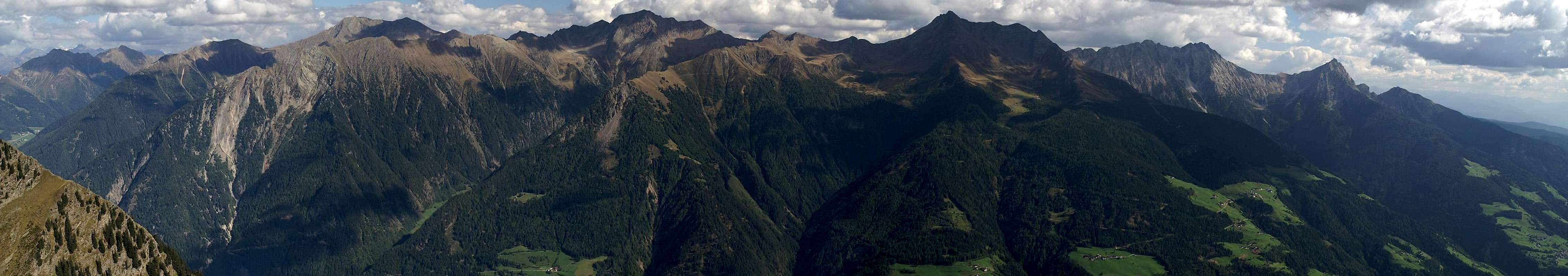
Thanks to its location on this easternmost ridge of the Ötztal Alps, Muthspitze itself offers some very fine views. Across the Passeiertal Valley the highest mountains of the Sarntal Alps loom Hochwart / Guardia Alta (2746m), Alpler Spitze / Punta Alpetta (2748m) and
Hirzer / Punta Cervina (2781m), to the north you find the suothernmost ridge of the
Stubai Alps (but views carry to the main ridge) and quite naturally the eastern Ötztal Alps are visible as well.
Muthspitze is far less popular than its slightly lower neighbour Matatzspitze / Punta Matatz to the north. This is mainly due to the fact that you find marked trails (with signs) towards the latter while Muthspitze is mentioned nowhere. Consequently you can be sure to be alone on its summit while across the saddle on Matatzspitze you can see crowds of people. Not the worst alternative, actually...
The Summit Views
JaufenspitzeWilde KreuzspitzeHochplattspitzeVerstadlspitzePlattenspitzeHochwartUnterbergTagewaldhornSchafbergAlpler SpitzePfandlspitzeHirzerHönigspitzeVidegger PlattenspitzeKanzel PlattenspitzeVerdinser PlattenspitzeGroßer IfingerLauwandspitze ![]() |
Getting There
The trailhead to Muthspitze is at Ulfas in upper Passeiertal / Val Passira. The area is remote and apart from the southern itinerary it takes quite a while to reach it.
- From the north
From the Inn Valley (Inntal Autobahn A12) take the road through Ötztal (B186) which leads up to the Timmelsjoch Pass / Passo del Rombo. Cross the border where the road turns into SS44b, which winds down to Moos in Passeier / Moso in Passira. Here follow the signs to Pfelders and at Platt / Plata leave it for Ulfas on a narrow mountain road. Drive through Ulfas to a parking lot above the village.
- From the south
Take the Brenner Motorway A22 to Bozen / Bolzano where you need to turn onto SS38, direction Meran / Merano. In Meran follow the signs to Timmelsjoch and Jaufenpass which lead you onto SS44 north through Passeiertal / Val Passira. At St. Leonhard / San Leonardo turn west onto SS44b to Timmelsjoch / Passo del Rombo, which leads you to Moos. From here follow the instructions above to Ulfas.
- From the east
If you take The Brenner Motorway from Innsbruck, leave it at Sterzing Vipiteno. Take SS44 across Jaufenpass / Passo Giovo to reach St. Leonard / San Leonardo. From there turn onto SS44b to Moos and follow the instructions above to Ulfas.
Red Tape
The whole area of the Texel Group / Gruppo di Tessa is a natural park, with 33.430ha the largest natural park of South Tyrol / Alto Adige. Restrictions apply - like keeping dogs on leash or leaving plants and animals in their habitat.
Accommodation
Weather Conditions
Maps & Books
Maps
- Digital Maps
- Regular Maps
- Meran / Merano
Kompass Map WK53
1:50000
ISBN: 3-85491-059-2
- Sterzing / Vipiteno
Kompass Map WK 44
1:50.000
ISBN: 3-85491-050-9
Books
- Meran-Burggrafenamt
Franziska Baumann
Kompass Guidebook WF951
Kompass Verlag
ISBN: 3-85491-386-9
- Rund um Meran
Henriette Klier
Rother Verlag
ISBN: 3-7633-4290-7

 7525 Hits
 86.37% Score
 22 Votes
 Looking down upon Muthspitze from the ridge to Kolbenspitze