
-
 7469 Hits
-
 80.49% Score
-
 12 Votes
|
|
Mountain/Rock |
|---|---|
|
|
46.77276°N / 11.10473°E |
|
|
Hiking |
|
|
Summer, Fall |
|
|
9337 ft / 2846 m |
|
|
Topographic isolation: 2 km
Nearest higher peak: Rötenspitze/Punta Rossa, 2873 m
Prominence: 201 m
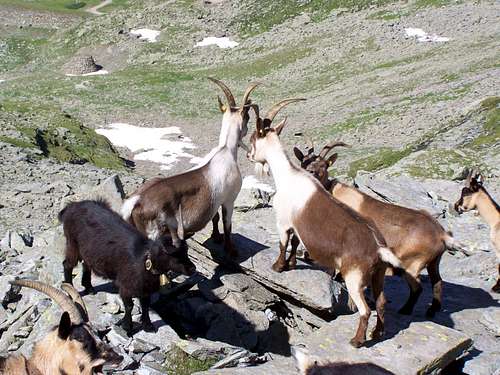
![Goats guarding the mountain]()
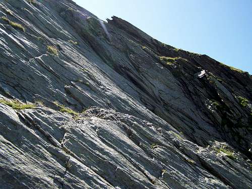
Goats guarding the mountain![Sefiarspitze is built of schist]()
Sefiarspitze is built of schistSefiarspitze/Monte Tavolino is the one of the peaks in the Texel Group of the Ötztal Alps in the northern side of the group, above the village Pfelders/Plan. The name of the peak is written as Sefiar Spitze, too.
The main ridge of the Texel Group is in a not quite straight west-east directional ridge. Sefiarspitze isn’t on this main ridge, but north to it, on a side ridge. Rötenspitze (2873 m) is there where this side ridge is connected to the main ridge. Anyway, Rötenspitze is the nearest higher peak to Sefiarspitze. The ridge connecting Rötenspitze and Sefiarspitze is very sharp, and not appropriate for hikers at all. There is a higher point of this ridge between Röten Spitze and Sefiarspitze, called Ulsenspitze/Punta di Ulsen (2737 m).
Sefiarspitze has two side-ridges: one to north, to Karjoch (2411m) and another one to northwest with a subpeak of 2536 m elevation.
North to the peak there is a valley called Pfelderer Tal/Val di Plan with the village of Pfelders/Plan in it. Sefiarspitze is more than 1200 meter above this valley. West to the peak there is a side-valley called Faltschnaltal, while east to the peak there is the valley of the steram Faltmar Bach.
The tourist trail called “Tiroler Höhenweg” (High Trail of Tirol) connecting Mayrhofen and Meran/Merano goes along the western and norther foot of Sefiarspitze. For a map showing both the Tiroler Höhenweg and Sefiarspitze in 1:50000 scale, click here.
Though the whole Texel Group is within the boundaries of the Naturpark Texelgruppe, the peak and its neighbourhood cannot be seen as being very much protected. In the village up to 2000 meter the minor grassy areas in the forest are intensively grazed by cattle. OK, the bottom few hundred meters of the valley is not part of the Natural Park. But cattles go into the area of the Natural Park, too. And moreover, the regions above 2000 meter, where there is no forest any more but only meadows – is clearly part of the protected area, and it is also intensively grazed. Not by cattle but by goats. At least these goats are very friendly.
The mountain is built of schist, sometimes with ribbons of marble in it. This can be seen well above 2600 m where there is very minimal vegetation and you can see almost only bare rocks.
![Lodner (3228 m) as seen from Sefiarspitze]()
View of the mighty Lodner (3228 m)Though there are many tourist path in the Texel Group, most of the peaks of the group cannot be accessed on marked paths. But Sefiarspitze is among the peaks that can be “climbed” on marked tourist path.
- If accidentally you are in the village of Pfelders, and you have not more than a half day, then this is the only peak that can be “bagged” in a short time
- No technical difficulty to ascend the summit. The steep parts of the path is built into the form of a stair. Tourist with not so good physical condition can use the cable car, too, to make the route shorter
- The view around is excellent, specifically to the main range of the Ötztal Alps, to the other peaks of Texel Group, and to Jaufenpass and Jaufenspitze.
o From Austria: Innsbruck – Brenner-pass – Sterzing/Vipiteno – Jaufenpass/Passo Giovo - St. Leonhard i. Passeier/S. Leonardo i. Passiria – Moos/Moso – Pfelders/Plan
o From Bolzano: Bozen/Bolzano – Meran/Merano – St. Leonhard i. Passeier/S. Leonardo i. Passiria - Moos/Moso – Pfelders/Plan
For South-Tirol public transport click here!
![Road from Pfelders]()
Road from Pfelders![Taking a photo about Liebnerspitze (3399 m)...]()
Between Grünbodenhütte and SefiarspitzeRoute from Pfelders
There is a single marked path going up to the peak of Sefiarspitze. This path starts at Grünbodenhütte/Malga Grünboden. The peak is very steep from all directions - other than the northern side where the marked path goes up – so does who don’t want to go up with alpinist techniques should go on this single marked route.
Grünbodenhütte can be accessed from many directions. But the most logical starting point is the parking place of the village Pfelders. The parking place is just at the eastern side of the village where the road coming from St. Leonhard i. Passeier arrives to the village. Though the parking place is quite large (120-140 places), in high season it can be difficult to find places there. So better to arrive early. But at least the parking place can be used without paying any fee. The parking place is in altitude 1620 m.
From Pfelders to Grünbodenhütte
There are several ways how to get up from the parking place to Grünbodenhütte. The hut is in altitude 2020 m. The 380 m difference between the parking place and the hut can be bridged in several ways.
> The easiest is method to get to the hut is to go with cable car. It operates between the 4th July – 27th September, in the hours 09:30-12:00 and 13:30-16:30.
> There is a 4 x 4 road going up from the village to the hut. This road is intensicely used now (2009) by trucks because the cable car construction is just being extended from Grünbodenhütte to Karjoch (2400 m). This work must be completed by December 2009. Though this road is in good condition, serious torist would not use such a road to reach a hut that can be accessed in other ways, too
> The most logical way up to the hut is the marked torist path nr. 5A. It is 1.5 km long and crosses a not very dense forest. The only difficulty with this path is to find the trailhead.
> Another longer possibility to go up to Äuß. Karhütte on path nr. 5, and from there to Grünbodenhütte on path nr. 5B. This route up to the hut is 3 km long.
> The longest route up to the hut starts on the path nr. 6 in direction of SW from Pfelders until it reaches Faltschnal Alm/Malga Faltschnal. From there the route must be continued on the trail called Panoramaweg in eastern direction. This trail has really good panoramic view to the main ridge of the Ötztal Alps, with the best view to Hinteren-Seelen Kogel/Cima d’Anime (3470 m) and to many neighbouring peaks, all of them over 3000 m. This route up to the hut is 4 km long.
From Grünbodenhütte to the peak of Sefiar Spitze
From the hut first follow the 4 x 4 road for 1 km. After 1 km turn right, following the red marks. Here you will cross an area where there are huge dams built of stone blocks, in order to prevent the hillside below from the avalanches coming down from Sefiarspitze. After the dams the hillside becomes steep. But the ascent is very easy – the path is built into the form of a stair. The only minor difficulty is that on the shady northern hillside a snow patch can cover the marked path even in late summer. So either you cross the snow patch or go around it, finding your own way. After 2.5 km you get up to a saddle that is in an approximate altitude of 2530 m. This saddle is between the main peak of Sefiarspitze and its subpeak (2536 m) northwest to it. From the saddle you have fantastic view. This is the first moment when the cross of Sefiarspitze can already be seen. From here a further 1 km steep ascend on the marked path and you are up on the peak without any difficulty.
The normal route from Pfelders up to the peak, using the trail Nr. 5B requires 5-6 hours for going up and return.![Summit photo on Sefiarspitze]()
On the summit of SefiarspitzeA nice metal cross is erected on the peak. There is a metal box equipped onto the cross, with a log book within it. According to the log book a daily average of 10 people climbs the peak.
From the peak you can have an excellent view if the peak is not in clouds. Several major peaks of the mountains around can be seen very well. Just some examples:
- Zuckerhütl (3507 m) to north
- Jaufenpass and Jaufenspitze (2481 m) to east
- Ulsenspitze (2737 m) and Rötenspitze (2873 m) to south
- The Dolomites to southeast
- Tschigat/Gigot (3000 m), Lodner/Cima Fiammante (3228 m) and Hohe Weisse/Cima Bianca Grande (3278 m) to southwest
- Erenspitze/Punta dell’Onore (2756 m) and Hohe Wilde/Altissima (3480 m) to west
- Hinterer Seelenkogel/Cima della Anima (3470 m) to northwest.![Grünbodenhütte and Karjoch above it]()
Grünbodenhütte
- Webcam of Pfelders
Maps
- Digital map of Italy
- Meran/Merano Kompass Map WK53, 1:50000, ISBN: 3-85491-059-2
- Sterzing/Vipiteno Kompass Map WK 44, 1:50000, ISBN: 3-85491-050-9
- Ötztal, Pitztal, Kaunertal, Wildspitze. Freitag & berndt WK251, 1:50000,
Books
- Meran-Burggrafenamt, Franziska Baumann, Kompass Guidebook WF951, Kompass Verlag, ISBN: 3-85491-386-9
- Rund um Meran, Henriette Klier, Rother Verlag, ISBN: 3-7633-4290-7
Nearest higher peak: Rötenspitze/Punta Rossa, 2873 m
Prominence: 201 m
Overview
Goats guarding the mountain
Sefiarspitze is built of schist
The main ridge of the Texel Group is in a not quite straight west-east directional ridge. Sefiarspitze isn’t on this main ridge, but north to it, on a side ridge. Rötenspitze (2873 m) is there where this side ridge is connected to the main ridge. Anyway, Rötenspitze is the nearest higher peak to Sefiarspitze. The ridge connecting Rötenspitze and Sefiarspitze is very sharp, and not appropriate for hikers at all. There is a higher point of this ridge between Röten Spitze and Sefiarspitze, called Ulsenspitze/Punta di Ulsen (2737 m).
Sefiarspitze has two side-ridges: one to north, to Karjoch (2411m) and another one to northwest with a subpeak of 2536 m elevation.
North to the peak there is a valley called Pfelderer Tal/Val di Plan with the village of Pfelders/Plan in it. Sefiarspitze is more than 1200 meter above this valley. West to the peak there is a side-valley called Faltschnaltal, while east to the peak there is the valley of the steram Faltmar Bach.
The tourist trail called “Tiroler Höhenweg” (High Trail of Tirol) connecting Mayrhofen and Meran/Merano goes along the western and norther foot of Sefiarspitze. For a map showing both the Tiroler Höhenweg and Sefiarspitze in 1:50000 scale, click here.
Though the whole Texel Group is within the boundaries of the Naturpark Texelgruppe, the peak and its neighbourhood cannot be seen as being very much protected. In the village up to 2000 meter the minor grassy areas in the forest are intensively grazed by cattle. OK, the bottom few hundred meters of the valley is not part of the Natural Park. But cattles go into the area of the Natural Park, too. And moreover, the regions above 2000 meter, where there is no forest any more but only meadows – is clearly part of the protected area, and it is also intensively grazed. Not by cattle but by goats. At least these goats are very friendly.
The mountain is built of schist, sometimes with ribbons of marble in it. This can be seen well above 2600 m where there is very minimal vegetation and you can see almost only bare rocks.
Why to go up?
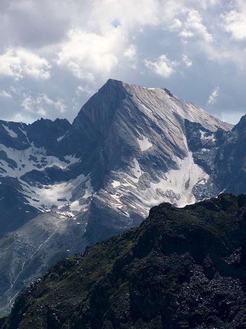
View of the mighty Lodner (3228 m)
- If accidentally you are in the village of Pfelders, and you have not more than a half day, then this is the only peak that can be “bagged” in a short time
- No technical difficulty to ascend the summit. The steep parts of the path is built into the form of a stair. Tourist with not so good physical condition can use the cable car, too, to make the route shorter
- The view around is excellent, specifically to the main range of the Ötztal Alps, to the other peaks of Texel Group, and to Jaufenpass and Jaufenspitze.
Getting there
With car:o From Austria: Innsbruck – Brenner-pass – Sterzing/Vipiteno – Jaufenpass/Passo Giovo - St. Leonhard i. Passeier/S. Leonardo i. Passiria – Moos/Moso – Pfelders/Plan
o From Bolzano: Bozen/Bolzano – Meran/Merano – St. Leonhard i. Passeier/S. Leonardo i. Passiria - Moos/Moso – Pfelders/Plan
For South-Tirol public transport click here!
Routes
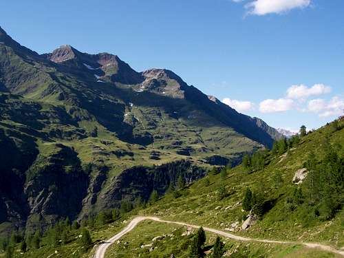
Road from Pfelders
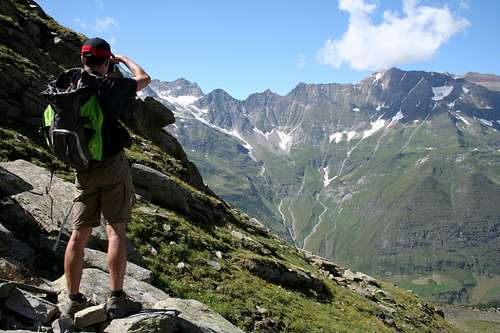
Between Grünbodenhütte and Sefiarspitze
There is a single marked path going up to the peak of Sefiarspitze. This path starts at Grünbodenhütte/Malga Grünboden. The peak is very steep from all directions - other than the northern side where the marked path goes up – so does who don’t want to go up with alpinist techniques should go on this single marked route.
Grünbodenhütte can be accessed from many directions. But the most logical starting point is the parking place of the village Pfelders. The parking place is just at the eastern side of the village where the road coming from St. Leonhard i. Passeier arrives to the village. Though the parking place is quite large (120-140 places), in high season it can be difficult to find places there. So better to arrive early. But at least the parking place can be used without paying any fee. The parking place is in altitude 1620 m.
From Pfelders to Grünbodenhütte
There are several ways how to get up from the parking place to Grünbodenhütte. The hut is in altitude 2020 m. The 380 m difference between the parking place and the hut can be bridged in several ways.
> The easiest is method to get to the hut is to go with cable car. It operates between the 4th July – 27th September, in the hours 09:30-12:00 and 13:30-16:30.
> There is a 4 x 4 road going up from the village to the hut. This road is intensicely used now (2009) by trucks because the cable car construction is just being extended from Grünbodenhütte to Karjoch (2400 m). This work must be completed by December 2009. Though this road is in good condition, serious torist would not use such a road to reach a hut that can be accessed in other ways, too
> The most logical way up to the hut is the marked torist path nr. 5A. It is 1.5 km long and crosses a not very dense forest. The only difficulty with this path is to find the trailhead.
> Another longer possibility to go up to Äuß. Karhütte on path nr. 5, and from there to Grünbodenhütte on path nr. 5B. This route up to the hut is 3 km long.
> The longest route up to the hut starts on the path nr. 6 in direction of SW from Pfelders until it reaches Faltschnal Alm/Malga Faltschnal. From there the route must be continued on the trail called Panoramaweg in eastern direction. This trail has really good panoramic view to the main ridge of the Ötztal Alps, with the best view to Hinteren-Seelen Kogel/Cima d’Anime (3470 m) and to many neighbouring peaks, all of them over 3000 m. This route up to the hut is 4 km long.
From Grünbodenhütte to the peak of Sefiar Spitze
From the hut first follow the 4 x 4 road for 1 km. After 1 km turn right, following the red marks. Here you will cross an area where there are huge dams built of stone blocks, in order to prevent the hillside below from the avalanches coming down from Sefiarspitze. After the dams the hillside becomes steep. But the ascent is very easy – the path is built into the form of a stair. The only minor difficulty is that on the shady northern hillside a snow patch can cover the marked path even in late summer. So either you cross the snow patch or go around it, finding your own way. After 2.5 km you get up to a saddle that is in an approximate altitude of 2530 m. This saddle is between the main peak of Sefiarspitze and its subpeak (2536 m) northwest to it. From the saddle you have fantastic view. This is the first moment when the cross of Sefiarspitze can already be seen. From here a further 1 km steep ascend on the marked path and you are up on the peak without any difficulty.
The normal route from Pfelders up to the peak, using the trail Nr. 5B requires 5-6 hours for going up and return.
On the peak
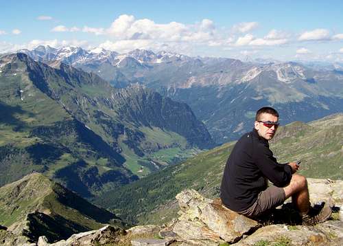
On the summit of Sefiarspitze
From the peak you can have an excellent view if the peak is not in clouds. Several major peaks of the mountains around can be seen very well. Just some examples:
- Zuckerhütl (3507 m) to north
- Jaufenpass and Jaufenspitze (2481 m) to east
- Ulsenspitze (2737 m) and Rötenspitze (2873 m) to south
- The Dolomites to southeast
- Tschigat/Gigot (3000 m), Lodner/Cima Fiammante (3228 m) and Hohe Weisse/Cima Bianca Grande (3278 m) to southwest
- Erenspitze/Punta dell’Onore (2756 m) and Hohe Wilde/Altissima (3480 m) to west
- Hinterer Seelenkogel/Cima della Anima (3470 m) to northwest.
Necessary gears
Difficulty: No technical difficulties in summer and in autumn. No dangerous exposures, except for the peak itself. No special gears are needed. A minor snow field may be on the path even in late summer.
In witnter and in sping there can be avalanche danger.
Red Tape
No special limitations, except for the rules that apply in the Natural Park. Danger of avalanche above GrünbodenhütteCamping and huts
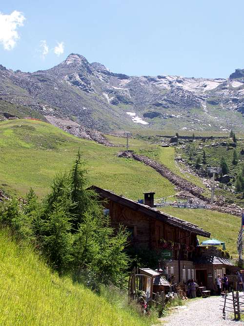
Grünbodenhütte
- Camping Passeier (500 m) – Tel. +39 0473 645454, I-39010 – Passeier Str., 10 Sankt Martin in Passeier
- Grünboden Hütte (2020 m) - Tel. +39 333 1421420
- Faltschnal Alm (1871 m) - Tel. +39 340 3808019

Weather conditions
- South Tyrol weather information- Webcam of Pfelders
Maps and books
Using information from one of the excellent pages of Gangolf HaubMaps
- Digital map of Italy
- Meran/Merano Kompass Map WK53, 1:50000, ISBN: 3-85491-059-2
- Sterzing/Vipiteno Kompass Map WK 44, 1:50000, ISBN: 3-85491-050-9
- Ötztal, Pitztal, Kaunertal, Wildspitze. Freitag & berndt WK251, 1:50000,
Books
- Meran-Burggrafenamt, Franziska Baumann, Kompass Guidebook WF951, Kompass Verlag, ISBN: 3-85491-386-9
- Rund um Meran, Henriette Klier, Rother Verlag, ISBN: 3-7633-4290-7